Huge post-tropical Hurricane Igor drenched Newfoundland, Canada
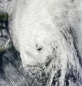
Hurricane Igor may have transitioned into a post-tropical hurricane late yesterday, but when he approached Newfoundland, Canada and merged with an area of low pressure it resulted in heavy rainfall throughout the region. NASA satellites captured Igor's northern march toward the Labrador Sea yesterday. NASA's Terra and Aqua satellites captured visible and infrared images of Hurricane Igor yesterday as he brought heavy rainfall into northeastern Canada. A visible image of Hurricane Igor over Newfoundland, Canada was captured by the Moderate Resolution Imaging Spectroradiometer (MODIS) instrument on NASA's Terra satellite on Sept. 21 at 14:15 UTC (10:15 a.m. EDT). At that time, Igor had re-strengthened and an eye appeared on the visible imagery.
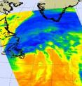
One and a half hours later, at 1553 UTC (11:53 a.m. EDT), NASA's Aqua satellite captured an infrared image of Hurricane Igor's cold thunderstorms that extended from Labrador, Canada eastward over southern Greenland. Igor was moving northward toward into the Labrador Sea toward Labrador and Baffin Island.
At 5 p.m. EDT on Sept. 21, Igor completed its post-tropical transition and its core went from a warm core, tropical system to a cold core system. At that time, he was 125 miles north-northeast of St. Johns, Newfoundland, Canada near 49.3 North and 51.7 West. Igor still had sustained hurricane-force winds of 80 mph although they are expected to weaken today, Sept. 22. Igor's minimum central pressure was 950 millibars, and he was moving north-northeast near a super-speedy 39 mph!
As Igor moved north his circulation continued increase. By 5 p.m. EDT on Sept. 21, tropical-storm force winds extended outward up to 520 miles from its center making the system over 1,000 miles wide!
Environment Canada noted that Hurricane Igor passed just south and east of Newfoundland on Tuesday, Sept. 21 and brought heavy rain and strong winds. Heavy rainfall extended far north and west of Igor's center as it neared Newfoundland, and hurricane-force winds were reported even into the evening.
A trough of low pressure (an elongated area of low pressure) that had passed over Newfoundland the day before (Monday) Igor arrived was still in the vicinity and interacted with the hurricane. The trough took moisture and energy from Igor and caused more heavy rainfall over the region. There were reports of extensive flooding, power outages and wind damage throughout the eastern half of Newfoundland over the last two days. Igor is one storm that the Atlantic will not miss.
Source: NASA/Goddard Space Flight Center
Articles on the same topic
- NASA sees important cloud-top temperatures as Tropical Storm Malakas heads for Iwo ToThu, 23 Sep 2010, 20:24:07 UTC
- NASA satellites help see ups and downs ahead for Depression LisaThu, 23 Sep 2010, 20:24:05 UTC
- GOES-13's wide view of Atlantic's Tropical Storm Lisa and low, Pacific's GeorgetteWed, 22 Sep 2010, 18:22:43 UTC
- Hurricane watches up in Canada as the GOES-13 Satellite sees Hurricane Igor still expandingTue, 21 Sep 2010, 19:56:38 UTC
- NASA infrared imagery sees tropical depression 14 becomes 12th tropical storm: LisaTue, 21 Sep 2010, 19:36:28 UTC
- NASA's MODIS and AIRS instruments watch Igor changing shape, warming over 3 daysMon, 20 Sep 2010, 19:29:18 UTC
- NASA sees Tropical Storm Julia getting 'dusted'Mon, 20 Sep 2010, 19:07:48 UTC
- NASA sees record-breaking Julia being affected by IgorFri, 17 Sep 2010, 20:22:51 UTC
- GOES-13 sees a weaker Hurricane Julia in the 'tropical trio'Thu, 16 Sep 2010, 18:50:52 UTC
- NASA's 3-D look into Hurricane Igor's heavy rainfallThu, 16 Sep 2010, 14:22:45 UTC
- NASA satellite measures monstrous Hurricane Igor as a '10 hour drive'Wed, 15 Sep 2010, 16:10:37 UTC
- Quick-intensifying Tropical Storm Karl landfalling in MexicoWed, 15 Sep 2010, 16:10:36 UTC
- Stunning NASA infrared imagery of Hurricane Igor reveals a 170 degree temperature differenceTue, 14 Sep 2010, 18:23:17 UTC
- NASA sees Tropical Storm Julia born with strong thunderstorms and heavy rainfallMon, 13 Sep 2010, 21:14:45 UTC
- Igor now a Category 4 hurricane with icy cloud tops and heavy rainfallMon, 13 Sep 2010, 21:01:34 UTC
Other sources
- GOES-13's wide view of Atlantic's Tropical Storm Lisa and low, Pacific's Georgettefrom PhysorgWed, 22 Sep 2010, 19:35:15 UTC
- Huge post-tropical Hurricane Igor drenched Newfoundland, Canadafrom PhysorgWed, 22 Sep 2010, 19:08:57 UTC
- Video: Hurricane Igor Pummels Bermudafrom CBSNews - ScienceWed, 22 Sep 2010, 0:21:24 UTC
- Hurricane watches up in Canada as the GOES-13 Satellite sees Hurricane Igor still expandingfrom Science BlogTue, 21 Sep 2010, 20:35:19 UTC
- Hurricane watches up in Canada as the GOES-13 Satellite sees Hurricane Igor still expandingfrom PhysorgTue, 21 Sep 2010, 20:28:14 UTC
- NASA infrared imagery sees tropical depression 14 becomes 12th tropical storm: Lisafrom PhysorgTue, 21 Sep 2010, 19:42:20 UTC
- NASA infrared imagery sees tropical depression 14 becomes 12th tropical storm: Lisafrom Science BlogTue, 21 Sep 2010, 19:28:21 UTC
- NASA's MODIS and AIRS instruments watch Igor changing shape, warming over 3 daysfrom PhysorgMon, 20 Sep 2010, 22:21:31 UTC
- NASA sees Tropical Storm Julia getting 'dusted'from PhysorgMon, 20 Sep 2010, 20:28:19 UTC
- NASA’s MODIS and AIRS instruments watch Igor changing shape, warming over 3 daysfrom Science BlogMon, 20 Sep 2010, 20:14:35 UTC
- NASA sees Tropical Storm Julia getting ‘dusted’from Science BlogMon, 20 Sep 2010, 20:14:28 UTC
- Video: Hurricane Igor Pummels Bermudafrom CBSNews - ScienceMon, 20 Sep 2010, 16:07:23 UTC
- Hurricane Igor, unchained, in NASA satellite imagesfrom PhysorgMon, 20 Sep 2010, 12:56:19 UTC
- Video: Hurricane Igor Pummels Bermudafrom CBSNews - ScienceMon, 20 Sep 2010, 12:21:29 UTC
- Hurricane Igor, Unchained, in NASA Satellite Imagesfrom NASA Jet Propulsion LaboratoryFri, 17 Sep 2010, 23:42:06 UTC
- NASA sees record-breaking Julia being affected by Igorfrom Science BlogFri, 17 Sep 2010, 20:35:20 UTC
- NASA sees record-breaking Julia being affected by Igorfrom PhysorgFri, 17 Sep 2010, 20:21:12 UTC
- OurAmazingPlanet: NASA Takes 3-D Look at Hurricane Igorfrom Space.comFri, 17 Sep 2010, 16:28:14 UTC
- GOES-13 sees a weaker Hurricane Julia in the ‘tropical trio’from Science BlogThu, 16 Sep 2010, 19:21:09 UTC
- GOES-13 sees a weaker Hurricane Julia in the 'tropical trio'from PhysorgThu, 16 Sep 2010, 19:07:15 UTC
- NASA’s 3-D look into Hurricane Igor’s heavy rainfallfrom Science BlogThu, 16 Sep 2010, 15:15:02 UTC
- NASA's 3-D look into Hurricane Igor's heavy rainfallfrom PhysorgThu, 16 Sep 2010, 14:35:20 UTC
- NASA calls Igor 'monstrous hurricane'from MSNBC: ScienceWed, 15 Sep 2010, 18:28:44 UTC
- NASA satellite measures monstrous Hurricane Igor as a '10 hour drive'from PhysorgWed, 15 Sep 2010, 17:35:25 UTC
- Quick-intensifying Tropical Storm Karl landfalling in Mexicofrom Science BlogWed, 15 Sep 2010, 17:28:09 UTC
- Quick-intensifying Tropical Storm Karl landfalling in Mexicofrom PhysorgWed, 15 Sep 2010, 17:14:21 UTC
- NASA Calls Igor 'Monstrous Hurricane'from Live ScienceWed, 15 Sep 2010, 16:49:30 UTC
- Astronauts Savor View of Hurricane 'Igor the Terrible' and Sister Stormfrom Space.comWed, 15 Sep 2010, 16:28:21 UTC
- Hurricane Igor as seen from spacefrom BBC News: Science & NatureWed, 15 Sep 2010, 13:49:35 UTC
- Video: Tracking Hurricane Igorfrom CBSNews - ScienceWed, 15 Sep 2010, 5:28:33 UTC
- Stunning NASA infrared imagery of Hurricane Igor reveals a 170 degree temperature differencefrom Science BlogTue, 14 Sep 2010, 18:35:17 UTC
- Stunning NASA infrared imagery of Hurricane Igor reveals a 170 degree temperature differencefrom PhysorgTue, 14 Sep 2010, 18:21:38 UTC
- Video: Tracking Hurricane Igorfrom CBSNews - ScienceTue, 14 Sep 2010, 9:14:12 UTC
- Video: Tracking Hurricane Igorfrom CBSNews - ScienceMon, 13 Sep 2010, 21:35:15 UTC
- Hurricane Igor Now Strongest Storm—But U.S. Spared Again?from National GeographicMon, 13 Sep 2010, 21:35:11 UTC
- NASA sees Tropical Storm Julia born with strong thunderstorms and heavy rainfallfrom PhysorgMon, 13 Sep 2010, 21:21:22 UTC
- NASA sees Tropical Storm Julia born with strong thunderstorms and heavy rainfallfrom Science BlogMon, 13 Sep 2010, 21:14:15 UTC
- NASA sees Tropical Storm Julia born with strong thunderstorms and heavy rainfallfrom Science BlogMon, 13 Sep 2010, 21:14:14 UTC
- Igor now a Category 4 hurricane with icy cloud tops and heavy rainfallfrom Science BlogMon, 13 Sep 2010, 21:14:13 UTC
- Igor now a Category 4 hurricane with icy cloud tops and heavy rainfallfrom PhysorgMon, 13 Sep 2010, 20:56:41 UTC
- Why Are Category 5 Hurricanes So Rare?from Live ScienceMon, 13 Sep 2010, 20:49:12 UTC
- Video: Tracking Hurricane Igorfrom CBSNews - ScienceMon, 13 Sep 2010, 20:49:10 UTC

