Igor now a Category 4 hurricane with icy cloud tops and heavy rainfall
NASA Satellites have noticed two distinct features in Igor that both indicate how powerful he has become, icy cold, high cloud tops and very heavy rainfall. NASA's Aqua and TRMM satellites have provided that insight to forecasters who are predicting Igor's next move as a powerful Category 4 Hurricane. Last week, Igor was a tropical storm who faded into a tropical depression. The National Hurricane Center had forecast that over the weekend Igor would approach more favorable conditions (low wind shear and warm sea surface temperatures) causing it to strengthen into a hurricane and it did. Tropical storm Igor was upgraded by the National Hurricane Center (NHC) in Miami, Florida to a hurricane on Sunday, September 12 at 0300 UTC (Sept. 11 at 11 p.m. EDT) .
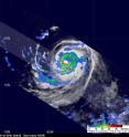
The Tropical Rainfall Measuring Mission (TRMM) satellite, which is operated jointly by NASA and the Japanese Space Agency, JAXA captured a good look at Igor a few hours after it reached hurricane status. TRMM passed over Igor and captured his rainfall rates at 0504UTC ( 1:04 a.m. EDT). The TRMM Precipitation Radar (PR) and TRMM Microwave Imager (TMI) instruments revealed that Igor had a well defined circular eye containing bands of heavy rainfall (falling at a rate of as much as 2 inches per hour).
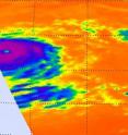
NASA's Aqua satellite captured an infrared image of Hurricane Igor on Sept. 12 at 15:53 UTC (1:53 p.m. EDT). At that time it showed strong convection and powerful thunderstorms around its center with cold cloud top temperatures between -76F to -94 Fahrenheit (-60 Celsius to -70 Celsius)! Igor's eye was also clearly seen in the infrared image.
On Sept. 13 at 11 a.m. EDT, Igor had maximum sustained winds near 150 mph and was a Category 4 hurricane on the Saffir-Simpson scale. The center of Hurricane Igor was located 880 miles east of the Northern Leeward Islands near latitude 17.5 north and longitude 49.7 west. Igor is moving toward the west near 10 mph and a turn toward the west-northwest is expected tonight or tomorrow. Estimated minimum central pressure is 933 millibars.
Igor is expected to remain a major hurricane for a couple of days.
Source: NASA/Goddard Space Flight Center
Articles on the same topic
- NASA sees important cloud-top temperatures as Tropical Storm Malakas heads for Iwo ToThu, 23 Sep 2010, 20:24:07 UTC
- NASA satellites help see ups and downs ahead for Depression LisaThu, 23 Sep 2010, 20:24:05 UTC
- GOES-13's wide view of Atlantic's Tropical Storm Lisa and low, Pacific's GeorgetteWed, 22 Sep 2010, 18:22:43 UTC
- Huge post-tropical Hurricane Igor drenched Newfoundland, CanadaWed, 22 Sep 2010, 18:22:42 UTC
- Hurricane watches up in Canada as the GOES-13 Satellite sees Hurricane Igor still expandingTue, 21 Sep 2010, 19:56:38 UTC
- NASA infrared imagery sees tropical depression 14 becomes 12th tropical storm: LisaTue, 21 Sep 2010, 19:36:28 UTC
- NASA's MODIS and AIRS instruments watch Igor changing shape, warming over 3 daysMon, 20 Sep 2010, 19:29:18 UTC
- NASA sees Tropical Storm Julia getting 'dusted'Mon, 20 Sep 2010, 19:07:48 UTC
- NASA sees record-breaking Julia being affected by IgorFri, 17 Sep 2010, 20:22:51 UTC
- GOES-13 sees a weaker Hurricane Julia in the 'tropical trio'Thu, 16 Sep 2010, 18:50:52 UTC
- NASA's 3-D look into Hurricane Igor's heavy rainfallThu, 16 Sep 2010, 14:22:45 UTC
- NASA satellite measures monstrous Hurricane Igor as a '10 hour drive'Wed, 15 Sep 2010, 16:10:37 UTC
- Quick-intensifying Tropical Storm Karl landfalling in MexicoWed, 15 Sep 2010, 16:10:36 UTC
- Stunning NASA infrared imagery of Hurricane Igor reveals a 170 degree temperature differenceTue, 14 Sep 2010, 18:23:17 UTC
- NASA sees Tropical Storm Julia born with strong thunderstorms and heavy rainfallMon, 13 Sep 2010, 21:14:45 UTC
Other sources
- GOES-13's wide view of Atlantic's Tropical Storm Lisa and low, Pacific's Georgettefrom PhysorgWed, 22 Sep 2010, 19:35:15 UTC
- Huge post-tropical Hurricane Igor drenched Newfoundland, Canadafrom PhysorgWed, 22 Sep 2010, 19:08:57 UTC
- Video: Hurricane Igor Pummels Bermudafrom CBSNews - ScienceWed, 22 Sep 2010, 0:21:24 UTC
- Hurricane watches up in Canada as the GOES-13 Satellite sees Hurricane Igor still expandingfrom Science BlogTue, 21 Sep 2010, 20:35:19 UTC
- Hurricane watches up in Canada as the GOES-13 Satellite sees Hurricane Igor still expandingfrom PhysorgTue, 21 Sep 2010, 20:28:14 UTC
- NASA infrared imagery sees tropical depression 14 becomes 12th tropical storm: Lisafrom PhysorgTue, 21 Sep 2010, 19:42:20 UTC
- NASA infrared imagery sees tropical depression 14 becomes 12th tropical storm: Lisafrom Science BlogTue, 21 Sep 2010, 19:28:21 UTC
- NASA's MODIS and AIRS instruments watch Igor changing shape, warming over 3 daysfrom PhysorgMon, 20 Sep 2010, 22:21:31 UTC
- NASA sees Tropical Storm Julia getting 'dusted'from PhysorgMon, 20 Sep 2010, 20:28:19 UTC
- NASA’s MODIS and AIRS instruments watch Igor changing shape, warming over 3 daysfrom Science BlogMon, 20 Sep 2010, 20:14:35 UTC
- NASA sees Tropical Storm Julia getting ‘dusted’from Science BlogMon, 20 Sep 2010, 20:14:28 UTC
- Video: Hurricane Igor Pummels Bermudafrom CBSNews - ScienceMon, 20 Sep 2010, 16:07:23 UTC
- Hurricane Igor, unchained, in NASA satellite imagesfrom PhysorgMon, 20 Sep 2010, 12:56:19 UTC
- Video: Hurricane Igor Pummels Bermudafrom CBSNews - ScienceMon, 20 Sep 2010, 12:21:29 UTC
- Hurricane Igor, Unchained, in NASA Satellite Imagesfrom NASA Jet Propulsion LaboratoryFri, 17 Sep 2010, 23:42:06 UTC
- NASA sees record-breaking Julia being affected by Igorfrom Science BlogFri, 17 Sep 2010, 20:35:20 UTC
- NASA sees record-breaking Julia being affected by Igorfrom PhysorgFri, 17 Sep 2010, 20:21:12 UTC
- OurAmazingPlanet: NASA Takes 3-D Look at Hurricane Igorfrom Space.comFri, 17 Sep 2010, 16:28:14 UTC
- GOES-13 sees a weaker Hurricane Julia in the ‘tropical trio’from Science BlogThu, 16 Sep 2010, 19:21:09 UTC
- GOES-13 sees a weaker Hurricane Julia in the 'tropical trio'from PhysorgThu, 16 Sep 2010, 19:07:15 UTC
- NASA’s 3-D look into Hurricane Igor’s heavy rainfallfrom Science BlogThu, 16 Sep 2010, 15:15:02 UTC
- NASA's 3-D look into Hurricane Igor's heavy rainfallfrom PhysorgThu, 16 Sep 2010, 14:35:20 UTC
- NASA calls Igor 'monstrous hurricane'from MSNBC: ScienceWed, 15 Sep 2010, 18:28:44 UTC
- NASA satellite measures monstrous Hurricane Igor as a '10 hour drive'from PhysorgWed, 15 Sep 2010, 17:35:25 UTC
- Quick-intensifying Tropical Storm Karl landfalling in Mexicofrom Science BlogWed, 15 Sep 2010, 17:28:09 UTC
- Quick-intensifying Tropical Storm Karl landfalling in Mexicofrom PhysorgWed, 15 Sep 2010, 17:14:21 UTC
- NASA Calls Igor 'Monstrous Hurricane'from Live ScienceWed, 15 Sep 2010, 16:49:30 UTC
- Astronauts Savor View of Hurricane 'Igor the Terrible' and Sister Stormfrom Space.comWed, 15 Sep 2010, 16:28:21 UTC
- Hurricane Igor as seen from spacefrom BBC News: Science & NatureWed, 15 Sep 2010, 13:49:35 UTC
- Video: Tracking Hurricane Igorfrom CBSNews - ScienceWed, 15 Sep 2010, 5:28:33 UTC
- Stunning NASA infrared imagery of Hurricane Igor reveals a 170 degree temperature differencefrom Science BlogTue, 14 Sep 2010, 18:35:17 UTC
- Stunning NASA infrared imagery of Hurricane Igor reveals a 170 degree temperature differencefrom PhysorgTue, 14 Sep 2010, 18:21:38 UTC
- Video: Tracking Hurricane Igorfrom CBSNews - ScienceTue, 14 Sep 2010, 9:14:12 UTC
- Video: Tracking Hurricane Igorfrom CBSNews - ScienceMon, 13 Sep 2010, 21:35:15 UTC
- Hurricane Igor Now Strongest Storm—But U.S. Spared Again?from National GeographicMon, 13 Sep 2010, 21:35:11 UTC
- NASA sees Tropical Storm Julia born with strong thunderstorms and heavy rainfallfrom PhysorgMon, 13 Sep 2010, 21:21:22 UTC
- NASA sees Tropical Storm Julia born with strong thunderstorms and heavy rainfallfrom Science BlogMon, 13 Sep 2010, 21:14:15 UTC
- NASA sees Tropical Storm Julia born with strong thunderstorms and heavy rainfallfrom Science BlogMon, 13 Sep 2010, 21:14:14 UTC
- Igor now a Category 4 hurricane with icy cloud tops and heavy rainfallfrom Science BlogMon, 13 Sep 2010, 21:14:13 UTC
- Igor now a Category 4 hurricane with icy cloud tops and heavy rainfallfrom PhysorgMon, 13 Sep 2010, 20:56:41 UTC
- Why Are Category 5 Hurricanes So Rare?from Live ScienceMon, 13 Sep 2010, 20:49:12 UTC
- Video: Tracking Hurricane Igorfrom CBSNews - ScienceMon, 13 Sep 2010, 20:49:10 UTC

