Hurricane watches up in Canada as the GOES-13 Satellite sees Hurricane Igor still expanding
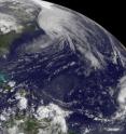
Hurricane Igor may be changing into an extra tropical storm and losing his warm core of energy, but he hasn't lost his punch as hurricane watches are up today in eastern Canada. The GOES-13 satellite captured a look at Hurricane Igor this morning, and noticed the storm continues to grow larger and part of that expansion is likely a result of absorbing Julia's remnants. The Geostationary Operational Environmental Satellite or GOES-13 is stationary in its position in space, watching over the weather in the eastern U.S. GOES-13 captured a visible satellite image of Hurricane Igor at 1145 UTC (7:45 a.m. EDT) today, Sept. 21 and the image showed Igor's huge size has continued to grow even larger over the last couple of days. Hurricane Igor is now about now 920 miles in diameter!
GOES-13 is operated by the National Oceanic and Atmospheric Administration, and images are created by NASA's GOES Project, located at NASA's Goddard Space Flight Center, Greenbelt, Md.
Igor is quickly losing tropical characteristics today and is transforming from a warm core system to a cold core system, just like typical low pressure systems in the northern hemisphere.
Igor's center was passing near Newfoundland at 11 a.m. EDT morning. As Igor moves north, a hurricane watch is in effect for the coast of Newfoundland from Stones Cove Northward and Eastward to Fogo Island and a Tropical Storm Warning is in Effect for the coast of Newfoundland from Burgeo Northward and Eastward to Triton and the islands of St-Pierre and Miquelon.
Hurricane Igor is maintaining hurricane strength with maximum sustained winds near 75 mph as he continues to track north. Hurricane-force winds extend 85 miles from his center, and tropical-storm force winds extend out to 460 miles, so his diameter has grown to a massive 920 miles!
At 11 a.m. the center of Hurricane Igor was located 35 miles south of Cape Race, Newfoundland, Canada, near 46.2 North and 52.8 West. Based on observations from southeastern Newfoundland this morning, Igor's minimum central pressure was 952 millibars. Igor is moving northeast at 46 mph and is forecast to turn to the north-northeast and then turn north on Wednesday as he continues to move into the cooler waters of the North Atlantic Ocean. Igor is forecast to become a strong extratropical cyclone later in the day.
Additional rainfall accumulations of 1 to 3 inches are possible over eastern Newfoundland today, totaling as much as between 4 and 8 inches of rainfall there from Igor. According to the National Hurricane Center, Canadian buoy 44139 located about 150 miles west of the center reported sustained winds of 62 mph (100 Km/hr) this morning, and Canadian buoy 41138 located just east of the center reported a pressure of 962 millibars.
On Sept. 15, Julia and Igor had both been powerful category four hurricanes but Julia's wind speeds had continued to drop since because of wind shear from monster hurricane Igor's outflow. By 11 a.m. EDT on Sept. 20, the National Hurricane Center issued their final warning on Julia. She was 1,100 miles west of the Azores near 34.7 North and 46.4 West and maximum sustained winds were near 46 mph, but quickly weakening. Julia had later been downgraded into a low pressure system and is now in the 2010 Atlantic Hurricane Season history books. Meanwhile, Igor's life history is not finished as he makes a track further into the North Atlantic Ocean.
Source: NASA/Goddard Space Flight Center
Articles on the same topic
- NASA sees important cloud-top temperatures as Tropical Storm Malakas heads for Iwo ToThu, 23 Sep 2010, 20:24:07 UTC
- NASA satellites help see ups and downs ahead for Depression LisaThu, 23 Sep 2010, 20:24:05 UTC
- GOES-13's wide view of Atlantic's Tropical Storm Lisa and low, Pacific's GeorgetteWed, 22 Sep 2010, 18:22:43 UTC
- Huge post-tropical Hurricane Igor drenched Newfoundland, CanadaWed, 22 Sep 2010, 18:22:42 UTC
- NASA infrared imagery sees tropical depression 14 becomes 12th tropical storm: LisaTue, 21 Sep 2010, 19:36:28 UTC
- NASA's MODIS and AIRS instruments watch Igor changing shape, warming over 3 daysMon, 20 Sep 2010, 19:29:18 UTC
- NASA sees Tropical Storm Julia getting 'dusted'Mon, 20 Sep 2010, 19:07:48 UTC
- NASA sees record-breaking Julia being affected by IgorFri, 17 Sep 2010, 20:22:51 UTC
- GOES-13 sees a weaker Hurricane Julia in the 'tropical trio'Thu, 16 Sep 2010, 18:50:52 UTC
- NASA's 3-D look into Hurricane Igor's heavy rainfallThu, 16 Sep 2010, 14:22:45 UTC
- NASA satellite measures monstrous Hurricane Igor as a '10 hour drive'Wed, 15 Sep 2010, 16:10:37 UTC
- Quick-intensifying Tropical Storm Karl landfalling in MexicoWed, 15 Sep 2010, 16:10:36 UTC
- Stunning NASA infrared imagery of Hurricane Igor reveals a 170 degree temperature differenceTue, 14 Sep 2010, 18:23:17 UTC
- NASA sees Tropical Storm Julia born with strong thunderstorms and heavy rainfallMon, 13 Sep 2010, 21:14:45 UTC
- Igor now a Category 4 hurricane with icy cloud tops and heavy rainfallMon, 13 Sep 2010, 21:01:34 UTC
Other sources
- GOES-13's wide view of Atlantic's Tropical Storm Lisa and low, Pacific's Georgettefrom PhysorgWed, 22 Sep 2010, 19:35:15 UTC
- Huge post-tropical Hurricane Igor drenched Newfoundland, Canadafrom PhysorgWed, 22 Sep 2010, 19:08:57 UTC
- Video: Hurricane Igor Pummels Bermudafrom CBSNews - ScienceWed, 22 Sep 2010, 0:21:24 UTC
- Hurricane watches up in Canada as the GOES-13 Satellite sees Hurricane Igor still expandingfrom Science BlogTue, 21 Sep 2010, 20:35:19 UTC
- Hurricane watches up in Canada as the GOES-13 Satellite sees Hurricane Igor still expandingfrom PhysorgTue, 21 Sep 2010, 20:28:14 UTC
- NASA infrared imagery sees tropical depression 14 becomes 12th tropical storm: Lisafrom PhysorgTue, 21 Sep 2010, 19:42:20 UTC
- NASA infrared imagery sees tropical depression 14 becomes 12th tropical storm: Lisafrom Science BlogTue, 21 Sep 2010, 19:28:21 UTC
- NASA's MODIS and AIRS instruments watch Igor changing shape, warming over 3 daysfrom PhysorgMon, 20 Sep 2010, 22:21:31 UTC
- NASA sees Tropical Storm Julia getting 'dusted'from PhysorgMon, 20 Sep 2010, 20:28:19 UTC
- NASA’s MODIS and AIRS instruments watch Igor changing shape, warming over 3 daysfrom Science BlogMon, 20 Sep 2010, 20:14:35 UTC
- NASA sees Tropical Storm Julia getting ‘dusted’from Science BlogMon, 20 Sep 2010, 20:14:28 UTC
- Video: Hurricane Igor Pummels Bermudafrom CBSNews - ScienceMon, 20 Sep 2010, 16:07:23 UTC
- Hurricane Igor, unchained, in NASA satellite imagesfrom PhysorgMon, 20 Sep 2010, 12:56:19 UTC
- Video: Hurricane Igor Pummels Bermudafrom CBSNews - ScienceMon, 20 Sep 2010, 12:21:29 UTC
- Hurricane Igor, Unchained, in NASA Satellite Imagesfrom NASA Jet Propulsion LaboratoryFri, 17 Sep 2010, 23:42:06 UTC
- NASA sees record-breaking Julia being affected by Igorfrom Science BlogFri, 17 Sep 2010, 20:35:20 UTC
- NASA sees record-breaking Julia being affected by Igorfrom PhysorgFri, 17 Sep 2010, 20:21:12 UTC
- OurAmazingPlanet: NASA Takes 3-D Look at Hurricane Igorfrom Space.comFri, 17 Sep 2010, 16:28:14 UTC
- GOES-13 sees a weaker Hurricane Julia in the ‘tropical trio’from Science BlogThu, 16 Sep 2010, 19:21:09 UTC
- GOES-13 sees a weaker Hurricane Julia in the 'tropical trio'from PhysorgThu, 16 Sep 2010, 19:07:15 UTC
- NASA’s 3-D look into Hurricane Igor’s heavy rainfallfrom Science BlogThu, 16 Sep 2010, 15:15:02 UTC
- NASA's 3-D look into Hurricane Igor's heavy rainfallfrom PhysorgThu, 16 Sep 2010, 14:35:20 UTC
- NASA calls Igor 'monstrous hurricane'from MSNBC: ScienceWed, 15 Sep 2010, 18:28:44 UTC
- NASA satellite measures monstrous Hurricane Igor as a '10 hour drive'from PhysorgWed, 15 Sep 2010, 17:35:25 UTC
- Quick-intensifying Tropical Storm Karl landfalling in Mexicofrom Science BlogWed, 15 Sep 2010, 17:28:09 UTC
- Quick-intensifying Tropical Storm Karl landfalling in Mexicofrom PhysorgWed, 15 Sep 2010, 17:14:21 UTC
- NASA Calls Igor 'Monstrous Hurricane'from Live ScienceWed, 15 Sep 2010, 16:49:30 UTC
- Astronauts Savor View of Hurricane 'Igor the Terrible' and Sister Stormfrom Space.comWed, 15 Sep 2010, 16:28:21 UTC
- Hurricane Igor as seen from spacefrom BBC News: Science & NatureWed, 15 Sep 2010, 13:49:35 UTC
- Video: Tracking Hurricane Igorfrom CBSNews - ScienceWed, 15 Sep 2010, 5:28:33 UTC
- Stunning NASA infrared imagery of Hurricane Igor reveals a 170 degree temperature differencefrom Science BlogTue, 14 Sep 2010, 18:35:17 UTC
- Stunning NASA infrared imagery of Hurricane Igor reveals a 170 degree temperature differencefrom PhysorgTue, 14 Sep 2010, 18:21:38 UTC
- Video: Tracking Hurricane Igorfrom CBSNews - ScienceTue, 14 Sep 2010, 9:14:12 UTC
- Video: Tracking Hurricane Igorfrom CBSNews - ScienceMon, 13 Sep 2010, 21:35:15 UTC
- Hurricane Igor Now Strongest Storm—But U.S. Spared Again?from National GeographicMon, 13 Sep 2010, 21:35:11 UTC
- NASA sees Tropical Storm Julia born with strong thunderstorms and heavy rainfallfrom PhysorgMon, 13 Sep 2010, 21:21:22 UTC
- NASA sees Tropical Storm Julia born with strong thunderstorms and heavy rainfallfrom Science BlogMon, 13 Sep 2010, 21:14:15 UTC
- NASA sees Tropical Storm Julia born with strong thunderstorms and heavy rainfallfrom Science BlogMon, 13 Sep 2010, 21:14:14 UTC
- Igor now a Category 4 hurricane with icy cloud tops and heavy rainfallfrom Science BlogMon, 13 Sep 2010, 21:14:13 UTC
- Igor now a Category 4 hurricane with icy cloud tops and heavy rainfallfrom PhysorgMon, 13 Sep 2010, 20:56:41 UTC
- Why Are Category 5 Hurricanes So Rare?from Live ScienceMon, 13 Sep 2010, 20:49:12 UTC
- Video: Tracking Hurricane Igorfrom CBSNews - ScienceMon, 13 Sep 2010, 20:49:10 UTC

