NASA's MODIS and AIRS instruments watch Igor changing shape, warming over 3 days
Related images
(click to enlarge)
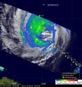
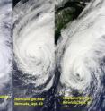
The Moderate Resolution Imaging Spectroradiometer or MODIS, is an instrument that flies on NASA's Aqua and Terra satellites and provides incredible views of tropical cyclones like Hurricane Igor, from its vantage point in space. Imagery from the MODIS instruments on these two satellites captured from Sept. 18 to 20 showed that powerful Hurricane Igor in the Atlantic Ocean is morphing from a rounded storm to more of a comma-shaped storm. The MODIS instrument on NASA's Terra satellite captured a visible image of Igor at 11:30 am on Sept. 18, while MODIS in the Aqua satellite captured Igor's center just southwest of Bermuda on Sept. 19 at 1:30 p.m. EDT. In imagery on both days, Hurricane Igor maintained a rounded shape and its eye was cloud-filled. When the MODIS instrument that flies aboard NASA's Terra satellite captured Igor after it passed Bermuda on Sept. 20 at 11:15 a.m. EDT, the imagery showed the Igor appeared elongated from south to north, and more resembled a comma-shape. There was even an eye visible in the latest image.
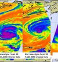
The Atmospheric Infrared Sounder Instrument (AIRS) that flies on NASA's Aqua satellite captured infrared images of Hurricane Igor's cold cloud temperatures and cloud cover on Sept. 18, Sept. 19, and Sept. 20. Igor lost its circular shape by Sept. 20, and there were very few high, strong thunderstorms where the cloud tops were colder than -63F. Infrared data from AIRS on Sept. 20 indicated that Igor was losing its strength as the cloud tops in the thunderstorms within were warming (less high in the atmosphere) and waning.
NASA and JAXA's Tropical Rainfall Measuring Mission (TRMM) satellite also continues to fly over Igor as he makes his track northward in the Atlantic Ocean.
Hurrricane Igor continued to weaken as the Tropical Rainfall Measuring Mission (TRMM) satellite passed over on September 19, 2010 at 0144 UTC showing that the hurricane no longer had an eye. Igor's wind speeds had decreased to about 75 knots (~86 mph) when TRMM collected the TRMM Microwave Imager (TMI) data used in the precipitation analysis. TRMM is managed by both NASA and the Japanese Space Agency.
By 2p.m. EDT on Sept. 20, all warnings and watches for Bermuda had been discontinued. Igor had moved about 350 miles north-northeast of Bermuda and was headed into the North Atlantic. It was located near 37.1 North and 62.5 West. Now, a tropical storm watch is in effect for the coast of Newfoundland from Stones Cove northward and Westward to Jones Harbour, Canada.
Igor was just barely a hurricane, with maximum sustained winds near 75 mph. It was moving northeast at 26 mph. Its minimum central pressure was 965 millibars.
Large swells will continue to affect Bermuda and the U.S. East coast through Tuesday, Sept. 21, causing life-threatening rip-currents and rough surf. Swells affecting the Lesser Antilles, the Virgin Islands, Puerto Rico, Hispaniola and the Bahamas will subside over the next couple of days.
Source: NASA/Goddard Space Flight Center
Articles on the same topic
- NASA sees important cloud-top temperatures as Tropical Storm Malakas heads for Iwo ToThu, 23 Sep 2010, 20:24:07 UTC
- NASA satellites help see ups and downs ahead for Depression LisaThu, 23 Sep 2010, 20:24:05 UTC
- GOES-13's wide view of Atlantic's Tropical Storm Lisa and low, Pacific's GeorgetteWed, 22 Sep 2010, 18:22:43 UTC
- Huge post-tropical Hurricane Igor drenched Newfoundland, CanadaWed, 22 Sep 2010, 18:22:42 UTC
- Hurricane watches up in Canada as the GOES-13 Satellite sees Hurricane Igor still expandingTue, 21 Sep 2010, 19:56:38 UTC
- NASA infrared imagery sees tropical depression 14 becomes 12th tropical storm: LisaTue, 21 Sep 2010, 19:36:28 UTC
- NASA sees Tropical Storm Julia getting 'dusted'Mon, 20 Sep 2010, 19:07:48 UTC
- NASA sees record-breaking Julia being affected by IgorFri, 17 Sep 2010, 20:22:51 UTC
- GOES-13 sees a weaker Hurricane Julia in the 'tropical trio'Thu, 16 Sep 2010, 18:50:52 UTC
- NASA's 3-D look into Hurricane Igor's heavy rainfallThu, 16 Sep 2010, 14:22:45 UTC
- NASA satellite measures monstrous Hurricane Igor as a '10 hour drive'Wed, 15 Sep 2010, 16:10:37 UTC
- Quick-intensifying Tropical Storm Karl landfalling in MexicoWed, 15 Sep 2010, 16:10:36 UTC
- Stunning NASA infrared imagery of Hurricane Igor reveals a 170 degree temperature differenceTue, 14 Sep 2010, 18:23:17 UTC
- NASA sees Tropical Storm Julia born with strong thunderstorms and heavy rainfallMon, 13 Sep 2010, 21:14:45 UTC
- Igor now a Category 4 hurricane with icy cloud tops and heavy rainfallMon, 13 Sep 2010, 21:01:34 UTC
Other sources
- GOES-13's wide view of Atlantic's Tropical Storm Lisa and low, Pacific's Georgettefrom PhysorgWed, 22 Sep 2010, 19:35:15 UTC
- Huge post-tropical Hurricane Igor drenched Newfoundland, Canadafrom PhysorgWed, 22 Sep 2010, 19:08:57 UTC
- Video: Hurricane Igor Pummels Bermudafrom CBSNews - ScienceWed, 22 Sep 2010, 0:21:24 UTC
- Hurricane watches up in Canada as the GOES-13 Satellite sees Hurricane Igor still expandingfrom Science BlogTue, 21 Sep 2010, 20:35:19 UTC
- Hurricane watches up in Canada as the GOES-13 Satellite sees Hurricane Igor still expandingfrom PhysorgTue, 21 Sep 2010, 20:28:14 UTC
- NASA infrared imagery sees tropical depression 14 becomes 12th tropical storm: Lisafrom PhysorgTue, 21 Sep 2010, 19:42:20 UTC
- NASA infrared imagery sees tropical depression 14 becomes 12th tropical storm: Lisafrom Science BlogTue, 21 Sep 2010, 19:28:21 UTC
- NASA's MODIS and AIRS instruments watch Igor changing shape, warming over 3 daysfrom PhysorgMon, 20 Sep 2010, 22:21:31 UTC
- NASA sees Tropical Storm Julia getting 'dusted'from PhysorgMon, 20 Sep 2010, 20:28:19 UTC
- NASA’s MODIS and AIRS instruments watch Igor changing shape, warming over 3 daysfrom Science BlogMon, 20 Sep 2010, 20:14:35 UTC
- NASA sees Tropical Storm Julia getting ‘dusted’from Science BlogMon, 20 Sep 2010, 20:14:28 UTC
- Video: Hurricane Igor Pummels Bermudafrom CBSNews - ScienceMon, 20 Sep 2010, 16:07:23 UTC
- Hurricane Igor, unchained, in NASA satellite imagesfrom PhysorgMon, 20 Sep 2010, 12:56:19 UTC
- Video: Hurricane Igor Pummels Bermudafrom CBSNews - ScienceMon, 20 Sep 2010, 12:21:29 UTC
- Hurricane Igor, Unchained, in NASA Satellite Imagesfrom NASA Jet Propulsion LaboratoryFri, 17 Sep 2010, 23:42:06 UTC
- NASA sees record-breaking Julia being affected by Igorfrom Science BlogFri, 17 Sep 2010, 20:35:20 UTC
- NASA sees record-breaking Julia being affected by Igorfrom PhysorgFri, 17 Sep 2010, 20:21:12 UTC
- OurAmazingPlanet: NASA Takes 3-D Look at Hurricane Igorfrom Space.comFri, 17 Sep 2010, 16:28:14 UTC
- GOES-13 sees a weaker Hurricane Julia in the ‘tropical trio’from Science BlogThu, 16 Sep 2010, 19:21:09 UTC
- GOES-13 sees a weaker Hurricane Julia in the 'tropical trio'from PhysorgThu, 16 Sep 2010, 19:07:15 UTC
- NASA’s 3-D look into Hurricane Igor’s heavy rainfallfrom Science BlogThu, 16 Sep 2010, 15:15:02 UTC
- NASA's 3-D look into Hurricane Igor's heavy rainfallfrom PhysorgThu, 16 Sep 2010, 14:35:20 UTC
- NASA calls Igor 'monstrous hurricane'from MSNBC: ScienceWed, 15 Sep 2010, 18:28:44 UTC
- NASA satellite measures monstrous Hurricane Igor as a '10 hour drive'from PhysorgWed, 15 Sep 2010, 17:35:25 UTC
- Quick-intensifying Tropical Storm Karl landfalling in Mexicofrom Science BlogWed, 15 Sep 2010, 17:28:09 UTC
- Quick-intensifying Tropical Storm Karl landfalling in Mexicofrom PhysorgWed, 15 Sep 2010, 17:14:21 UTC
- NASA Calls Igor 'Monstrous Hurricane'from Live ScienceWed, 15 Sep 2010, 16:49:30 UTC
- Astronauts Savor View of Hurricane 'Igor the Terrible' and Sister Stormfrom Space.comWed, 15 Sep 2010, 16:28:21 UTC
- Hurricane Igor as seen from spacefrom BBC News: Science & NatureWed, 15 Sep 2010, 13:49:35 UTC
- Video: Tracking Hurricane Igorfrom CBSNews - ScienceWed, 15 Sep 2010, 5:28:33 UTC
- Stunning NASA infrared imagery of Hurricane Igor reveals a 170 degree temperature differencefrom Science BlogTue, 14 Sep 2010, 18:35:17 UTC
- Stunning NASA infrared imagery of Hurricane Igor reveals a 170 degree temperature differencefrom PhysorgTue, 14 Sep 2010, 18:21:38 UTC
- Video: Tracking Hurricane Igorfrom CBSNews - ScienceTue, 14 Sep 2010, 9:14:12 UTC
- Video: Tracking Hurricane Igorfrom CBSNews - ScienceMon, 13 Sep 2010, 21:35:15 UTC
- Hurricane Igor Now Strongest Storm—But U.S. Spared Again?from National GeographicMon, 13 Sep 2010, 21:35:11 UTC
- NASA sees Tropical Storm Julia born with strong thunderstorms and heavy rainfallfrom PhysorgMon, 13 Sep 2010, 21:21:22 UTC
- NASA sees Tropical Storm Julia born with strong thunderstorms and heavy rainfallfrom Science BlogMon, 13 Sep 2010, 21:14:15 UTC
- NASA sees Tropical Storm Julia born with strong thunderstorms and heavy rainfallfrom Science BlogMon, 13 Sep 2010, 21:14:14 UTC
- Igor now a Category 4 hurricane with icy cloud tops and heavy rainfallfrom Science BlogMon, 13 Sep 2010, 21:14:13 UTC
- Igor now a Category 4 hurricane with icy cloud tops and heavy rainfallfrom PhysorgMon, 13 Sep 2010, 20:56:41 UTC
- Why Are Category 5 Hurricanes So Rare?from Live ScienceMon, 13 Sep 2010, 20:49:12 UTC
- Video: Tracking Hurricane Igorfrom CBSNews - ScienceMon, 13 Sep 2010, 20:49:10 UTC


