NASA satellites see Super-Typhoon Haiyan lashing the Philippines
Related images
(click to enlarge)
Super-Typhoon Haiyan was lashing the central and southern Philippines on Nov. 7 bringing maximum sustained winds of a Category 5 hurricane. NASA is providing visible, infrared and microwave satellite data to forecasters and warnings are in effect for the Philippines and Micronesia as Haiyan moves west. Brian McNoldy, a Senior Research Associate at the University of Miami's Rosenstiel School of Marine and Atmospheric Science in Miami, Fla. noted that on the morning (EST) of Nov. 7, "Haiyan has achieved tropical cyclone perfection. It is now estimated at 165kts (190mph), with an 8.0 on the Dvorak scale... the highest possible value."
Warnings in the Philippines have been raise throughout much of the country. In Luzon:
Signal #1 is in effect for : Camarines Norte & Sur, Catanduanes, Mindoro Provinces, Marinduque, Northern Palawan, Calamian Group of Islands, and Southern Quezon.
Signal #2 is in effect for: Romblon, Sorsogon, Albay, Ticao and Burias island.
In Visayas, Signal #1 is in effect for Squijor, and Signal #2 is in effect for: Bohol, Negros Occidental and Oriental, Aklan, Capiz, Antique, rest of Cebu, Iloilo and Guimara. Signal #3 is in effect for: Northern Samar, Masbate, northern Cebu, Cebu City and Bantayan island, and Signal #4 is in effect for: Eastern Samar, Samar, Leyte, Southern Leyte and Biliran island.
In Mindanao, Signal #1 was posted for: Misamis Oriental, Agusan del Sur; Signal #2 for: Camiguin, Surigao del Norte & Sur and Agusan del Norte and Signal #3 is in effect for: Siargao Island and Dinagat province.
In Micronesia, a Typhoon Warning is in effect for Kayangel and Koror in the Republic of Palau and Ngulu in Yap State.
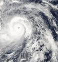
Early on Nov. 7, NASA's Aqua satellite passed over Super Typhoon Haiyan as it was approaching the Philippines. The Moderate Resolution Imaging Spectroradiometer or MODIS instrument aboard captured a visible image on Nov. 7, 2013 at 04:25 UTC/Nov. 6 at 11:25 p.m. EDT that showed the thick bands of powerful thunderstorms that surrounded the eye. The MODIS image also revealed a powerful, wide band of thunderstorms in the western quadrant that was affecting the Philippines in the early morning hours (Eastern Daylight Time/U.S.) on Nov. 7.
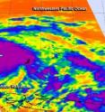
At the same time, another instrument aboard Aqua captured infrared data on the storm using the Atmospheric Infrared Sounder or AIRS instrument, providing cloud top temperatures and sea surface temperatures. The infrared data revealed a sharply defined eye with multiple concentric rings of thunderstorms and a deep convective eyewall. The infrared data showed cloud top temperatures as cold as 210 degrees kelvin/-81.67F/-63.15C/ in the thick band of thunderstorms around the center. Those cold temperatures indicate very high, powerful thunderstorms with very heavy rain potential.
On Nov. 7 at 1500 UTC/10 a.m. EDT, Super-Typhoon Haiyan's maximum sustained winds were near 165 knots/189.9 mph/305.6 kph. Haiyan is a Category 5 storm on the Saffir-Simpson hurricane scale. The Joint Typhoon Warning Center estimated that gusts are as strong as 200 knots/ 230.2 mph/370.4 kph.
The U.S. National Hurricane Center website indicates that a Category 5 hurricane/typhoon would cause catastrophic damage: A high percentage of framed homes will be destroyed, with total roof failure and wall collapse. Fallen trees and power poles will isolate residential areas. Power outages will last for weeks to possibly months. Most of the area will be uninhabitable for weeks or months.
Haiyan was located near 10.4 north latitude and 128.1 east longitude, about 543 nautical miles east-southeast of Manila, Philippines. It is moving west-northwest at 22 knots/25.3 mph/40.7 kph and generating extremely rough seas with wave heights to 50 feet/15.2 meters.
The Joint Typhoon Warning Center noted that extremely favorable environmental conditions such as the warm waters ahead of the system will help to maintain its strength at super typhoon intensity through landfall in the central Philippines and up to 1500 UTC/10 a.m. EDT on Nov. 8. According to forecast track, Manila is now expected to be impacted by the northeastern quadrant, the strongest side of the storm.
After passing through the Philippines, Haiyan is expected to move through the South China Sea as it heads for landfall in Vietnam.
Source: NASA
Other sources
- Philippines to plant more mangroves in wake of Typhoon Haiyanfrom PhysorgSun, 24 Nov 2013, 16:00:19 UTC
- Photojournalist Captures Resiliency in the Philippines After Typhoon Haiyanfrom National GeographicSat, 23 Nov 2013, 16:00:16 UTC
- Haiyan Destruction in Philippines Visible from Spacefrom Space.comThu, 21 Nov 2013, 19:00:30 UTC
- Focus on Poverty: Lessons from Typhoon Haiyanfrom SciDevThu, 21 Nov 2013, 13:20:17 UTC
- Crowd-sourcing Goes Mainstream in Typhoon Haiyan Responsefrom Scientific AmericanWed, 20 Nov 2013, 23:00:29 UTC
- Haiyan's path of destruction in Philippines visible from spacefrom MSNBC: ScienceWed, 20 Nov 2013, 19:01:38 UTC
- Evidence of destruction in Tacloban, Philippinesfrom PhysorgWed, 20 Nov 2013, 18:00:46 UTC
- Haiyan Destruction in Philippines Visible from Spacefrom Live ScienceWed, 20 Nov 2013, 18:00:19 UTC
- Michael Mann: Super Typhoon Haiyan and the Realities of a Warmed World (Op-Ed)from Live ScienceTue, 19 Nov 2013, 18:50:20 UTC
- Typhoon Haiyan turns UBC researchers into rescuersfrom CBC: Technology & ScienceTue, 19 Nov 2013, 17:30:19 UTC
- After Haiyan: how to act on scientific advice that's politically inconvenient?from The Guardian - ScienceTue, 19 Nov 2013, 13:00:57 UTC
- Measuring the Might of Haiyanfrom NY Times ScienceMon, 18 Nov 2013, 23:40:07 UTC
- Weatherwatch: Carbon released in the Philippines might never be recoveredfrom The Guardian - ScienceMon, 18 Nov 2013, 6:00:24 UTC
- Weatherwatch: Carbon released in the Philippines might never be recoveredfrom The Guardian - ScienceSun, 17 Nov 2013, 22:00:21 UTC
- Haiyan's Aftermath: 7 Key Steps to Recoveryfrom Live ScienceFri, 15 Nov 2013, 20:30:38 UTC
- Major Hurricanes and Typhoons Compared (Infographic)from Live ScienceFri, 15 Nov 2013, 20:30:32 UTC
- UN tasks imaging satellites for Haiyan relieffrom PhysorgThu, 14 Nov 2013, 23:30:29 UTC
- Why Typhoon Haiyan Was More Intense Than Hurricane Katrinafrom Live ScienceThu, 14 Nov 2013, 23:00:48 UTC
- Haiyan-Battered Philippine Cities Struggle to Resurrect Networksfrom Scientific AmericanThu, 14 Nov 2013, 22:30:22 UTC
- At a Philippine Hospital, Survivors Face Quiet Despairfrom NY Times HealthThu, 14 Nov 2013, 21:51:46 UTC
- Typhoon Haiyan's gravest destruction mapped with satellite datafrom MSNBC: ScienceThu, 14 Nov 2013, 19:01:15 UTC
- NASA Maps to Aid Super Typhoon Haiyan Disaster Relieffrom Space.comThu, 14 Nov 2013, 18:30:18 UTC
- NASA Maps to Aid Super Typhoon Haiyan Disaster Relieffrom Live ScienceThu, 14 Nov 2013, 18:00:20 UTC
- NASA Damage Map Helps in Typhoon Disaster Responsefrom NASA Jet Propulsion LaboratoryThu, 14 Nov 2013, 17:31:23 UTC
- Haiyan and Tropical Storm 30W bring heavy rains to the Phillipinesfrom PhysorgThu, 14 Nov 2013, 17:30:45 UTC
- Challenges facing relief workers in Philippinesfrom Harvard ScienceThu, 14 Nov 2013, 16:30:25 UTC
- NASA damage map helps in typhoon disaster responsefrom PhysorgThu, 14 Nov 2013, 14:00:40 UTC
- Typhoon Haiyan: How Technology Can Helpfrom Live ScienceWed, 13 Nov 2013, 23:30:23 UTC
- 2013 is 7th hottest year so farfrom CBC: Technology & ScienceWed, 13 Nov 2013, 18:30:25 UTC
- Emotional Speech by Philippine Delegatefrom NY Times ScienceWed, 13 Nov 2013, 18:10:13 UTC
- UN: Besides Haiyan, 2013 storm season near averagefrom PhysorgWed, 13 Nov 2013, 18:00:34 UTC
- UN: Besides Haiyan, 2013 storm season near averagefrom AP ScienceWed, 13 Nov 2013, 13:00:28 UTC
- Typhoon Haiyan is 'wake-up call'from BBC News: Science & NatureWed, 13 Nov 2013, 12:00:33 UTC
- Devastation in Philippines Draws Support for People and Pets (Op-Ed)from Live ScienceWed, 13 Nov 2013, 3:00:31 UTC
- Video: Typhoon Haiyan seen from the International Space Stationfrom CBSNews - ScienceWed, 13 Nov 2013, 1:00:25 UTC
- Typhoon Haiyan seen from International Space Stationfrom CBSNews - ScienceWed, 13 Nov 2013, 1:00:23 UTC
- NASA satellites track Typhoon Haiyan's second landfall and flood potentialfrom PhysorgTue, 12 Nov 2013, 19:30:41 UTC
- Typhoon Haiyan Was Not the Size of the USfrom Live ScienceTue, 12 Nov 2013, 16:30:28 UTC
- Five Reasons for Nature’s Deadly Toll in the Philippinesfrom National GeographicTue, 12 Nov 2013, 15:00:21 UTC
- Typhoon Haiyan seen from space - videofrom The Guardian - ScienceTue, 12 Nov 2013, 11:00:33 UTC
- Typhoon in Philippines Casts Long Shadow Over U.N. Talks on Climate Treatyfrom NY Times ScienceTue, 12 Nov 2013, 4:20:07 UTC
- Did Climate Change Cause Typhoon Haiyan?from Scientific AmericanTue, 12 Nov 2013, 3:30:14 UTC
- How Typhoon Haiyan Compares to the 2004 Tsunamifrom Live ScienceMon, 11 Nov 2013, 23:30:34 UTC
- Typhoon Haiyan pushed the limit, but bigger storms are comingfrom MSNBC: ScienceMon, 11 Nov 2013, 23:30:33 UTC
- Photo Gallery: Typhoon Haiyan Hits Philippinesfrom Live ScienceMon, 11 Nov 2013, 21:30:35 UTC
- Astronaut Sees Super Typhoon Haiyan from Space (Photo)from Space.comMon, 11 Nov 2013, 20:00:38 UTC
- Astronaut Sees Super Typhoon Haiyan from Space (Photo)from Live ScienceMon, 11 Nov 2013, 20:00:33 UTC
- US Military Aids Recovery in Typhoon-Ravaged Philippinesfrom Live ScienceMon, 11 Nov 2013, 19:30:41 UTC
- UN climate talks in Warsaw darkened by Typhoon Haiyanfrom CBC: Technology & ScienceMon, 11 Nov 2013, 19:30:34 UTC
- Typhoon Haiyan overshadows U.N. climate talks as Philippines envoy breaks down in tearsfrom CBSNews - ScienceMon, 11 Nov 2013, 18:30:24 UTC
- Typhoon Haiyan overshadows U.N. climate talks as Philippines envoy breaks town in tearsfrom CBSNews - ScienceMon, 11 Nov 2013, 18:00:14 UTC
- Typhoon Haiyan overshadows UN climate talksfrom PhysorgMon, 11 Nov 2013, 17:01:23 UTC
- Haiyan-Ravaged Philippines Face Another Tropical Threatfrom Live ScienceMon, 11 Nov 2013, 16:30:21 UTC
- Video: Typhoon Haiyan: Why it's one of the most powerful on recordfrom CBSNews - ScienceMon, 11 Nov 2013, 16:00:30 UTC
- Typhoon prompts climate 'fast'from BBC News: Science & NatureMon, 11 Nov 2013, 14:00:38 UTC
- Typhoon Haiyan: Philippines urges action to resolve climate talks deadlockfrom The Guardian - ScienceMon, 11 Nov 2013, 13:00:30 UTC
- Typhoon Haiyan: we cannot afford to procrastinate on climate actionfrom The Guardian - ScienceMon, 11 Nov 2013, 12:30:16 UTC
- UN climate talks open amid 'sobering' typhoonfrom PhysorgMon, 11 Nov 2013, 12:01:19 UTC
- FEATURE: Super Typhoon Haiyan hits Philippines with devastating forcefrom Science AlertMon, 11 Nov 2013, 7:30:50 UTC
- NASA Peers Into One of Earth's Strongest Storms Everfrom NASA Jet Propulsion LaboratorySat, 9 Nov 2013, 1:00:23 UTC
- Super Typhoon Haiyan: Full of Sound and Fury and Signifying …?from Science NOWFri, 8 Nov 2013, 23:20:08 UTC
- NASA's TRMM satellite sees Super-typhoon Haiyan strike Philippinesfrom PhysorgFri, 8 Nov 2013, 20:30:40 UTC
- Typhoon Haiyan the biggest yet as world's tropical storms gather forcefrom The Guardian - ScienceFri, 8 Nov 2013, 20:30:37 UTC
- Powerful Typhoon Causes Mass Disruption in Philippinesfrom NY Times ScienceFri, 8 Nov 2013, 19:10:12 UTC
- Big Pic: Super Typhoon Haiyan, As Seen From Spacefrom PopSciFri, 8 Nov 2013, 19:00:23 UTC
- NASA sees Super-Typhoon Haiyan maintain strength crossing Philippinesfrom PhysorgFri, 8 Nov 2013, 17:00:57 UTC
- Super-Typhoon Haiyan maintains strength crossing Philippinesfrom Science DailyFri, 8 Nov 2013, 17:00:54 UTC
- Super-Typhoon Haiyan lashes the Philippinesfrom Science DailyFri, 8 Nov 2013, 14:30:25 UTC
- NASA keeps an eye on ferocious Super Typhoon Haiyan from spacefrom MSNBC: ScienceFri, 8 Nov 2013, 0:00:52 UTC
- Super Typhoon Haiyan Headed Toward Philippinesfrom National GeographicThu, 7 Nov 2013, 23:00:52 UTC
- NASA Tracks Super Typhoon Haiyan From Space (Photos)from Space.comThu, 7 Nov 2013, 23:00:19 UTC
- NASA satellites see Super-Typhoon Haiyan lashing the Philippinesfrom PhysorgThu, 7 Nov 2013, 19:01:20 UTC
- How Typhoon Haiyan Became Year's Most Intense Stormfrom Live ScienceThu, 7 Nov 2013, 17:30:42 UTC
- NASA sees heavy rain around Super-Typhoon Haiyan's eyefrom PhysorgWed, 6 Nov 2013, 20:00:44 UTC
- NASA investigates Typhoon Haiyan's intense rainfallfrom PhysorgTue, 5 Nov 2013, 18:30:45 UTC
- NASA sees strengthening Tropical Storm Haiyan lashing Micronesiafrom PhysorgMon, 4 Nov 2013, 18:30:32 UTC

