NASA satellite and International Space Station catch Earl weakening
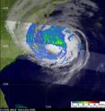
NASA satellites and the International Space Station are keeping eyes on Hurricane Earl as it heads for New England. Watches and Warnings are posted in the U.S. northeast. Having felt the effects of both increasing wind shear and cooler waters, Hurricane Earl weakened to a Category 2 storm on the Saffir-Simpson scale with winds still powerful at 90 knots (104 mph) as it neared the North Carolina coast. It was at this time that the Tropical Rainfall Measuring Mission (TRMM) satellite captured the data about TRMM's rainfall rates.
The rainfall pattern associated with Earl and was made using data from the TRMM satellite when it flew over the storm on September 3 at 08:22 UTC (4:22 a.m. EDT). Rainbands from Earl were visible over the outer banks, eastern North Carolina, and southeastern Virginia, but the storm no longer has a well-defined eye. TRMM observed moderate rainfall mostly to the north of Earl's center.
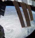
Meanwhile, from a second vantage point in space, at the International Space Station, Astronaut Douglas Wheelock caught an image of the eye of the storm on September 3. As the ISS flew over Hurricane Earl Wheelock noted that it looked like magnificent chaos from up there on the Space Station and called it incredibly breathtaking.
At 11 a.m. EDT on Sept. 3, Hurricane Earl's maximum sustained winds were near 85 mph. It was located about 350 miles south-southwest of Nantucket, Mass. near 36.8 North and 73.1 West. Earl's minimum central pressure was 961 millibars, and he was moving north-northeast at 21 mph.
Because Earl is now forecast to track farther away from the coast, many of the watches and warnings have been discontinued, but new watches and warnings are in place. The current watches and warnings in effect include: a hurricane warning is in effect for Woods Hole eastward around Cape Cod to Sagamore Beach Massachusetts, including Marthas Vineyard and Nantucket Island. In addition a Hurricane Watch is now in effect for Nova Scotia, Canada from Ecum Secum westward to Digby.
Earl is expected to weaken further as it continues northward over cooler waters along the Eastern Seaboard. Updates on Earl are available through the National Hurricane Center at www.nhc.noaa.gov and through the NASA Hurricane twitter page.
Source: NASA/Goddard Space Flight Center
Articles on the same topic
- GOES-13 satellite sees Hurricane Earl's clouds covering the US NortheastFri, 3 Sep 2010, 14:17:19 UTC
- NASA hurricane researchers eye Earl's eyeFri, 3 Sep 2010, 14:17:16 UTC
- NASA catches heavy rainfall happening in Category 4 Earl as it approaches the USThu, 2 Sep 2010, 20:38:21 UTC
- Hurricane warnings posted on US East Coast, NASA sees Earl's heavy rainfallWed, 1 Sep 2010, 18:23:36 UTC
Other sources
- CIMAS, NOAA research conduct innovative investigations to study Hurricane Earlfrom PhysorgTue, 7 Sep 2010, 19:56:12 UTC
- Hurricanes Throw Birds Off Coursefrom Live ScienceTue, 7 Sep 2010, 16:56:15 UTC
- Hurricanes like Earl throw birds off coursefrom MSNBC: ScienceTue, 7 Sep 2010, 15:49:14 UTC
- Hurricane's Path Unfamiliar to U.S. Northeastfrom CBSNews - ScienceMon, 6 Sep 2010, 16:28:43 UTC
- Video: Diminished Earl Still A Threatfrom CBSNews - ScienceMon, 6 Sep 2010, 16:28:28 UTC
- How Are Hurricanes Named?from Live ScienceSun, 5 Sep 2010, 14:42:11 UTC
- As a Hurricane, Earl Looked Like 'Magnificent Chaos' From Spacefrom Space.comSat, 4 Sep 2010, 13:28:09 UTC
- Video: Diminished Earl Still A Threatfrom CBSNews - ScienceSat, 4 Sep 2010, 9:49:13 UTC
- Video: Diminished Earl Still A Threatfrom CBSNews - ScienceSat, 4 Sep 2010, 9:21:46 UTC
- Video: Diminished Earl Still A Threatfrom CBSNews - ScienceFri, 3 Sep 2010, 23:56:17 UTC
- Video: Diminished Earl Still A Threatfrom CBSNews - ScienceFri, 3 Sep 2010, 23:35:17 UTC
- Weaker Hurricane Earl heads for New Englandfrom LA Times - ScienceFri, 3 Sep 2010, 22:28:13 UTC
- NASA satellite and International Space Station catch Earl weakeningfrom PhysorgFri, 3 Sep 2010, 21:49:05 UTC
- Why Hurricane Earl Weakened on Path to Cape Codfrom National GeographicFri, 3 Sep 2010, 21:42:12 UTC
- NASA satellite and International Space Station catch Earl weakeningfrom Science BlogFri, 3 Sep 2010, 20:14:13 UTC
- NASA hurricane researchers eye Earl’s eyefrom Science BlogFri, 3 Sep 2010, 15:21:19 UTC
- GOES-13 satellite sees Hurricane Earl’s clouds covering the US Northeastfrom Science BlogFri, 3 Sep 2010, 15:21:18 UTC
- GOES-13 satellite sees Hurricane Earl's clouds covering the US Northeastfrom PhysorgFri, 3 Sep 2010, 14:42:13 UTC
- NASA hurricane researchers eye Earl's eyefrom PhysorgFri, 3 Sep 2010, 14:21:11 UTC
- Hurricane's Path Unfamiliar to U.S. Northeastfrom CBSNews - ScienceFri, 3 Sep 2010, 12:21:14 UTC
- Hurricane's Path Unfamiliar to U.S. Northeastfrom CBSNews - ScienceFri, 3 Sep 2010, 10:28:08 UTC
- Earl takes swipe at North Carolina, heads northfrom LA Times - ScienceFri, 3 Sep 2010, 3:42:11 UTC
- Hurricane's Path Unfamiliar to U.S. Northeastfrom CBSNews - ScienceFri, 3 Sep 2010, 2:14:22 UTC
- NASA Hurricane Researchers Eye Earl's Eyefrom NASA Jet Propulsion LaboratoryFri, 3 Sep 2010, 1:56:19 UTC
- Hurricane's Path Unfamiliar to U.S. Northeastfrom CBSNews - ScienceFri, 3 Sep 2010, 1:28:11 UTC
- Earl's path along northeast is not well-wornfrom PhysorgThu, 2 Sep 2010, 22:07:23 UTC
- Earl's path along northeast is not well-wornfrom AP ScienceThu, 2 Sep 2010, 22:07:18 UTC
- Hurricane Earl a Harbinger of Worse to Come?from National GeographicThu, 2 Sep 2010, 22:07:13 UTC
- NASA catches heavy rainfall happening in Category 4 Earl as it approaches the USfrom PhysorgThu, 2 Sep 2010, 21:21:54 UTC
- Hurricane Earl approaches East Coastfrom LA Times - ScienceThu, 2 Sep 2010, 5:28:10 UTC
- East Coast Braces for Earlfrom CBSNews - ScienceThu, 2 Sep 2010, 2:07:42 UTC
- Video: East Coast Preps for Hurricane Earlfrom CBSNews - ScienceThu, 2 Sep 2010, 2:07:13 UTC
- NASA Images Dissect Hurricane Earlfrom NASA Jet Propulsion LaboratoryThu, 2 Sep 2010, 1:28:22 UTC
- Hurricane prompts US evacuationsfrom BBC News: Science & NatureThu, 2 Sep 2010, 1:07:16 UTC
- East Coast Braces for Earlfrom CBSNews - ScienceThu, 2 Sep 2010, 0:35:23 UTC
- Video: East Coast Preps for Hurricane Earlfrom CBSNews - ScienceThu, 2 Sep 2010, 0:35:16 UTC
- East Coast Braces for Earlfrom CBSNews - ScienceThu, 2 Sep 2010, 0:14:15 UTC
- Video: East Coast Preps for Hurricane Earlfrom CBSNews - ScienceThu, 2 Sep 2010, 0:14:14 UTC
- East Coast Braces for Earlfrom CBSNews - ScienceWed, 1 Sep 2010, 23:49:17 UTC
- Video: East Coast Preps for Hurricane Earlfrom CBSNews - ScienceWed, 1 Sep 2010, 23:49:15 UTC
- Hurricane warnings posted on US East Coast, NASA sees Earl's heavy rainfallfrom PhysorgWed, 1 Sep 2010, 22:07:20 UTC
- As East Coast Braces For Hurricane Earl, NASA Watches From Abovefrom PopSciWed, 1 Sep 2010, 21:35:29 UTC
- Could New York City Handle a Hurricane?from Live ScienceWed, 1 Sep 2010, 21:35:26 UTC
- Hurricane warnings posted on US East Coast, NASA sees Earl’s heavy rainfallfrom Science BlogWed, 1 Sep 2010, 18:42:12 UTC
- Inside Hurricane Earl: Bumpy Flight, Spectacular Viewfrom Live ScienceWed, 1 Sep 2010, 17:49:14 UTC
- Video: Fears over Hurricane Earlfrom CBSNews - ScienceWed, 1 Sep 2010, 8:14:26 UTC
- Video: Fears over Hurricane Earlfrom CBSNews - ScienceWed, 1 Sep 2010, 7:49:22 UTC
- Video: Fears over Hurricane Earlfrom CBSNews - ScienceWed, 1 Sep 2010, 5:14:26 UTC
- Video: Fears over Hurricane Earlfrom CBSNews - ScienceTue, 31 Aug 2010, 23:35:21 UTC
- An Eye on Earl: RENCI Models the Path of Hurricane as Its Heads Towards the East Coastfrom Newswise - ScinewsTue, 31 Aug 2010, 20:28:19 UTC
- Hurricane Earl May Skim N. Carolina as Strong Stormfrom National GeographicTue, 31 Aug 2010, 19:14:09 UTC
- Hurricane Earl Photographed From Space by Astronautfrom Space.comTue, 31 Aug 2010, 15:14:43 UTC
- Hurricane Earl from spacefrom MSNBC: ScienceTue, 31 Aug 2010, 14:07:24 UTC
- Hurricane Earl's Path Skirts U.S.—No Hurricane Fiona?from National GeographicMon, 30 Aug 2010, 22:56:11 UTC
- Hurricane hunters fly into Earlfrom MSNBC: ScienceMon, 30 Aug 2010, 18:49:09 UTC
- Hurricane Earl threatens north Caribbeanfrom CBC: Technology & ScienceMon, 30 Aug 2010, 12:21:10 UTC

