NASA hurricane researchers eye Earl's eye
Hurricane Earl, currently a Category Two storm on the Saffir-Simpson scale with maximum sustained winds of 100 knots (115 miles per hour), continues to push relentlessly toward the U.S. East Coast, and NASA scientists, instruments and spacecraft are busy studying the storm from the air and space. Three NASA aircraft carrying 15 instruments are busy criss-crossing Earl as part of the agency's Genesis and Rapid Intensification Processes mission, or GRIP, which continues through Sept. 30. GRIP is designed to help improve our understanding of how hurricanes such as Earl form and intensify rapidly. Among the instruments participating in GRIP is the High-Altitude Monolithic Microwave Integrated Circuit Sounding Radiometer, or HAMSR, developed by NASA's Jet Propulsion Laboratory, Pasadena, Calif. The instrument, which flies aboard NASA's Global Hawk uninhabited aerial vehicle, infers the 3-D distribution of temperature, water vapor and cloud liquid water in the atmosphere.
The Global Hawk left NASA's Dryden Flight Research Center, Edwards, Calif., at 9 p.m. PDT on Sept. 1, and emerged off the coast of Florida seven hours later to begin its first-ever flight over a hurricane. The plane spent the day today flying over Earl and is returning to Dryden tonight. An image of Earl as seen the morning of Sept. 2 from a high-definition camera aboard the Global Hawk is shown in Figure 3.
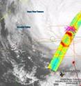
HAMSR has been able to make multiple passes straight across Earl's eye. Figure 1 shows brightness temperature data collected by HAMSR over a half-hour sequence of overpasses around 3 p.m. EDT on Sept. 2. The Global Hawk was flying at an altitude of about 19.2 kilometers (63,000 feet) approximately 1,125 kilometers (700 miles) off Florida's east coast. Earl's eye is visible as the blue-green circular area in the center of the image, surrounded by orange-red. The eye is colored blue-green because the instrument is seeing the ocean surface, which appears cool to the instrument. The surrounding clouds appear warm because they shield the cooler ocean surface from view. Just north of the ring of clouds is a deep blue arch, which represents a burst of convection (intense thunderstorms). The pink crosses in the image represent lightning in the area, as measured by a lightning network. Ice particles and heavy precipitation in the convective storm cell cause it to appear cold.
This image illustrates many of the capabilities of HAMSR, from measuring sea surface and atmospheric temperature to measuring convection and precipitation. For example, since there is a clear view of Earl's eye down to the ocean surface, scientists can determine the change of atmospheric temperatures at different altitudes within the eye, an indication of the strength of convection in the core of the storm. This warming is due to the condensation of water vapor that has been lofted to higher altitudes by the strong convection. This is the engine that powers the storm. That temperature data, in turn, can be used to estimate the intensity of the hurricane. NOAA's National Hurricane Center is currently using this method to determine hurricane intensity.
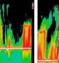
A second JPL instrument participating in GRIP and flying over Earl is the Airborne Precipitation Radar (APR-2), a dual-frequency weather radar that is taking 3-D images of precipitation aboard NASA's DC-8 aircraft. APR-2 is being used to help scientists understand the processes at work in hurricanes by looking at the vertical structure of the storms.
The two APR-2 images that make up Figure 2 reveal the early evolution of Hurricane Earl from a rather disorganized storm (left) to a better developed hurricane with a more distinct and smaller eye and sharper eyewall (right). The data, taken during southbound passes over Earl's eye on Aug. 29 and 30, respectively, are essentially vertical slices of the storm. They correspond to the intensity of precipitation seen by the radar along the DC-8's flight track. Intense convective precipitation (shown in shades of red and pink) was observed on both sides of the hurricane's eye. The eye is indicated by the dark region near the middle of the images. The yellow-green-colored regions indicate areas of lighter precipitation. The white lines near the bottom are the ocean surface.
Source: NASA/Goddard Space Flight Center
Articles on the same topic
- NASA satellite and International Space Station catch Earl weakeningFri, 3 Sep 2010, 19:50:23 UTC
- GOES-13 satellite sees Hurricane Earl's clouds covering the US NortheastFri, 3 Sep 2010, 14:17:19 UTC
- NASA catches heavy rainfall happening in Category 4 Earl as it approaches the USThu, 2 Sep 2010, 20:38:21 UTC
- Hurricane warnings posted on US East Coast, NASA sees Earl's heavy rainfallWed, 1 Sep 2010, 18:23:36 UTC
Other sources
- CIMAS, NOAA research conduct innovative investigations to study Hurricane Earlfrom PhysorgTue, 7 Sep 2010, 19:56:12 UTC
- Hurricanes Throw Birds Off Coursefrom Live ScienceTue, 7 Sep 2010, 16:56:15 UTC
- Hurricanes like Earl throw birds off coursefrom MSNBC: ScienceTue, 7 Sep 2010, 15:49:14 UTC
- Hurricane's Path Unfamiliar to U.S. Northeastfrom CBSNews - ScienceMon, 6 Sep 2010, 16:28:43 UTC
- Video: Diminished Earl Still A Threatfrom CBSNews - ScienceMon, 6 Sep 2010, 16:28:28 UTC
- How Are Hurricanes Named?from Live ScienceSun, 5 Sep 2010, 14:42:11 UTC
- As a Hurricane, Earl Looked Like 'Magnificent Chaos' From Spacefrom Space.comSat, 4 Sep 2010, 13:28:09 UTC
- Video: Diminished Earl Still A Threatfrom CBSNews - ScienceSat, 4 Sep 2010, 9:49:13 UTC
- Video: Diminished Earl Still A Threatfrom CBSNews - ScienceSat, 4 Sep 2010, 9:21:46 UTC
- Video: Diminished Earl Still A Threatfrom CBSNews - ScienceFri, 3 Sep 2010, 23:56:17 UTC
- Video: Diminished Earl Still A Threatfrom CBSNews - ScienceFri, 3 Sep 2010, 23:35:17 UTC
- Weaker Hurricane Earl heads for New Englandfrom LA Times - ScienceFri, 3 Sep 2010, 22:28:13 UTC
- NASA satellite and International Space Station catch Earl weakeningfrom PhysorgFri, 3 Sep 2010, 21:49:05 UTC
- Why Hurricane Earl Weakened on Path to Cape Codfrom National GeographicFri, 3 Sep 2010, 21:42:12 UTC
- NASA satellite and International Space Station catch Earl weakeningfrom Science BlogFri, 3 Sep 2010, 20:14:13 UTC
- NASA hurricane researchers eye Earl’s eyefrom Science BlogFri, 3 Sep 2010, 15:21:19 UTC
- GOES-13 satellite sees Hurricane Earl’s clouds covering the US Northeastfrom Science BlogFri, 3 Sep 2010, 15:21:18 UTC
- GOES-13 satellite sees Hurricane Earl's clouds covering the US Northeastfrom PhysorgFri, 3 Sep 2010, 14:42:13 UTC
- NASA hurricane researchers eye Earl's eyefrom PhysorgFri, 3 Sep 2010, 14:21:11 UTC
- Hurricane's Path Unfamiliar to U.S. Northeastfrom CBSNews - ScienceFri, 3 Sep 2010, 12:21:14 UTC
- Hurricane's Path Unfamiliar to U.S. Northeastfrom CBSNews - ScienceFri, 3 Sep 2010, 10:28:08 UTC
- Earl takes swipe at North Carolina, heads northfrom LA Times - ScienceFri, 3 Sep 2010, 3:42:11 UTC
- Hurricane's Path Unfamiliar to U.S. Northeastfrom CBSNews - ScienceFri, 3 Sep 2010, 2:14:22 UTC
- NASA Hurricane Researchers Eye Earl's Eyefrom NASA Jet Propulsion LaboratoryFri, 3 Sep 2010, 1:56:19 UTC
- Hurricane's Path Unfamiliar to U.S. Northeastfrom CBSNews - ScienceFri, 3 Sep 2010, 1:28:11 UTC
- Earl's path along northeast is not well-wornfrom PhysorgThu, 2 Sep 2010, 22:07:23 UTC
- Earl's path along northeast is not well-wornfrom AP ScienceThu, 2 Sep 2010, 22:07:18 UTC
- Hurricane Earl a Harbinger of Worse to Come?from National GeographicThu, 2 Sep 2010, 22:07:13 UTC
- NASA catches heavy rainfall happening in Category 4 Earl as it approaches the USfrom PhysorgThu, 2 Sep 2010, 21:21:54 UTC
- Hurricane Earl approaches East Coastfrom LA Times - ScienceThu, 2 Sep 2010, 5:28:10 UTC
- East Coast Braces for Earlfrom CBSNews - ScienceThu, 2 Sep 2010, 2:07:42 UTC
- Video: East Coast Preps for Hurricane Earlfrom CBSNews - ScienceThu, 2 Sep 2010, 2:07:13 UTC
- NASA Images Dissect Hurricane Earlfrom NASA Jet Propulsion LaboratoryThu, 2 Sep 2010, 1:28:22 UTC
- Hurricane prompts US evacuationsfrom BBC News: Science & NatureThu, 2 Sep 2010, 1:07:16 UTC
- East Coast Braces for Earlfrom CBSNews - ScienceThu, 2 Sep 2010, 0:35:23 UTC
- Video: East Coast Preps for Hurricane Earlfrom CBSNews - ScienceThu, 2 Sep 2010, 0:35:16 UTC
- East Coast Braces for Earlfrom CBSNews - ScienceThu, 2 Sep 2010, 0:14:15 UTC
- Video: East Coast Preps for Hurricane Earlfrom CBSNews - ScienceThu, 2 Sep 2010, 0:14:14 UTC
- East Coast Braces for Earlfrom CBSNews - ScienceWed, 1 Sep 2010, 23:49:17 UTC
- Video: East Coast Preps for Hurricane Earlfrom CBSNews - ScienceWed, 1 Sep 2010, 23:49:15 UTC
- Hurricane warnings posted on US East Coast, NASA sees Earl's heavy rainfallfrom PhysorgWed, 1 Sep 2010, 22:07:20 UTC
- As East Coast Braces For Hurricane Earl, NASA Watches From Abovefrom PopSciWed, 1 Sep 2010, 21:35:29 UTC
- Could New York City Handle a Hurricane?from Live ScienceWed, 1 Sep 2010, 21:35:26 UTC
- Hurricane warnings posted on US East Coast, NASA sees Earl’s heavy rainfallfrom Science BlogWed, 1 Sep 2010, 18:42:12 UTC
- Inside Hurricane Earl: Bumpy Flight, Spectacular Viewfrom Live ScienceWed, 1 Sep 2010, 17:49:14 UTC
- Video: Fears over Hurricane Earlfrom CBSNews - ScienceWed, 1 Sep 2010, 8:14:26 UTC
- Video: Fears over Hurricane Earlfrom CBSNews - ScienceWed, 1 Sep 2010, 7:49:22 UTC
- Video: Fears over Hurricane Earlfrom CBSNews - ScienceWed, 1 Sep 2010, 5:14:26 UTC
- Video: Fears over Hurricane Earlfrom CBSNews - ScienceTue, 31 Aug 2010, 23:35:21 UTC
- An Eye on Earl: RENCI Models the Path of Hurricane as Its Heads Towards the East Coastfrom Newswise - ScinewsTue, 31 Aug 2010, 20:28:19 UTC
- Hurricane Earl May Skim N. Carolina as Strong Stormfrom National GeographicTue, 31 Aug 2010, 19:14:09 UTC
- Hurricane Earl Photographed From Space by Astronautfrom Space.comTue, 31 Aug 2010, 15:14:43 UTC
- Hurricane Earl from spacefrom MSNBC: ScienceTue, 31 Aug 2010, 14:07:24 UTC
- Hurricane Earl's Path Skirts U.S.—No Hurricane Fiona?from National GeographicMon, 30 Aug 2010, 22:56:11 UTC
- Hurricane hunters fly into Earlfrom MSNBC: ScienceMon, 30 Aug 2010, 18:49:09 UTC
- Hurricane Earl threatens north Caribbeanfrom CBC: Technology & ScienceMon, 30 Aug 2010, 12:21:10 UTC

