Tropical Storm Alex now in Gulf of Mexico, brought heavy rainfall to Belize, Yucatan
Related images
(click to enlarge)
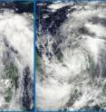
NASA's infrared satellite imagery captured high, cold, strong thunderstorms within Tropical Storm Alex over the past weekend and they are still creating heavy rainfall. Alex's center is now moving out into the southwestern Gulf of Mexico and departing the Yucatan Peninsula. Alex is moving into warm waters and is expected to strengthen into a hurricane in the next day. Today, June 28, a tropical storm warning is in effect for the coast of Belize and the east coast of the Yucatan Peninsula of Mexico from Chetumal to Cancun.
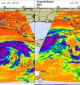
NASA's Atmospheric Infrared Sounder (AIRS) instrument aboard the Aqua satellite captured infrared imagery on June 26 and 27 that showed the areas of high, cold, thunderstorm cloud tops and the warm western Caribbean waters.
On June 26 at 1800 UTC (2 p.m. EDT) AIRS infrared imagery showed a large concentration of powerful thunderstorms around Alex's center while it dropped very heavy rainfall on Honduras, Belize and Guatemala.
On June 27 at 2 a.m. EDT, AIRS imagery showed the largest concentration of thunderstorms over the Yucatan Peninsula. The AIRS instrument also senses the heat from the warm sea surface of the Caribbean and the Gulf of Mexico and showed that those temperatures were as warm as or warmer than the 80 degree Fahrenheit threshold needed to power tropical cyclones.
ALEX'S HISTORY
On Friday, June 25 at 6 p.m. EDT, System 93L developed into the first tropical depression of the Atlantic Ocean hurricane season. By 8 p.m. EDT on the 25, Tropical Depression One was nearing tropical storm strength, so a tropical storm warning was issued for Belize. Three hours later, Tropical Depression One was still moving west-northwestward toward Belize and the Yucatan. At 11:25 p.m. EDT, Tropical Storm Watches went up for Honduras.
It wasn't until 5 a.m. EDT on Saturday, June 26 that Tropical Depression One strengthened into a tropical storm and was named Alex. By 2 p.m. EDT that day, Alex was a large tropical storm and still moving toward Belize and the Yucatan. Three hours later that day and Air Force plane noted that Alex had strengthened and weather in Belize and the Yucatan was deteriorating rapidly. By 7 p.m. EDT, Alex was near the Belize coast and it was dumping heavy rainfall in northern Guatemala and the Yucatan Peninsula. By 10 p.m. EDT on June 26, Alex was making landfall over Belize, some 20 miles (20 km) northwest of Belize City with maximum sustained winds near 60 mph.
By 5 a.m. EDT on Monday, June 28, the National Hurricane Center noted that Alex is now getting better organized and is pulling away from the Yucatan Peninsula. Alex is about 75 miles (115 km) west of Campeche, Mexico; 440 miles (710 km) east-southeast of Tampico, Mexico, near 19.7 North and 91.6 West. Maximum sustained winds at that time were near 50 mph and minimum central pressure was 990 millibars.
Rainfall is the largest threat from Alex, as the storm is expected to produce total rain accumulations of 4 to 8 inches over the Yucatan Peninsula, southern Mexico and portions of Guatemala through Tuesday. Isolated maximum amounts of 15 inches are possible over mountainous areas. These rains could cause life-threatening flash floods and mudslides.
At 8 a.m. EDT, Hurricane Hunter aircraft reported sustained winds inside the storm near 66 mph, and a minimum central pressure near 989 millibars. Alex is also in an environmental area that will help Alex strengthen over the next several days as it heads north into the western Gulf of Mexico. Tropical Storm watches maybe required later today for coastal areas of northeastern Mexico and south Texas.
Source: NASA/Goddard Space Flight Center
Articles on the same topic
- GOES-13 satellite catches Alex as a tropical storm now, after a landfall in northeastern MexicoThu, 1 Jul 2010, 17:45:32 UTC
- NASA data see Alex's core aligned, growing toward hurricane strengthTue, 29 Jun 2010, 21:24:08 UTC
Other sources
- GOES-13 satellite catches Alex as a tropical storm now, after a landfall in northeastern Mexicofrom Science BlogThu, 1 Jul 2010, 18:14:26 UTC
- GOES-13 satellite catches Alex as a tropical storm now, after a landfall in northeastern Mexicofrom Science BlogThu, 1 Jul 2010, 18:14:24 UTC
- Pictures: Hurricane Alex Pushes Oil on "Cleaned" Beachesfrom National GeographicWed, 30 Jun 2010, 23:56:11 UTC
- Video: Weather Hinders Spill Clean Upfrom CBSNews - ScienceWed, 30 Jun 2010, 23:35:14 UTC
- Hurricane Alex Pushes "Worst Oil" Ashore; Cleanup Slowedfrom National GeographicWed, 30 Jun 2010, 22:28:09 UTC
- Hurricanes May Be Good for Gulf Oil Spill, Experts Sayfrom National GeographicWed, 30 Jun 2010, 19:07:09 UTC
- Gulf oil cleanup derailed by hurricanefrom CBC: Technology & ScienceWed, 30 Jun 2010, 17:50:31 UTC
- Alex Stirs Up the Gulffrom PhysorgWed, 30 Jun 2010, 16:35:28 UTC
- Video: Bad Weather Halts Spill Relieffrom CBSNews - ScienceWed, 30 Jun 2010, 14:35:42 UTC
- Gulf Woes Grow as Hurricane Threat Mountsfrom Live ScienceWed, 30 Jun 2010, 14:28:16 UTC
- Biden visits gulf as storm approachesfrom LA Times - ScienceWed, 30 Jun 2010, 5:21:15 UTC
- Video: Bad Weather Halts Spill Relieffrom CBSNews - ScienceWed, 30 Jun 2010, 2:28:23 UTC
- Video: Bad Weather Halts Spill Relieffrom CBSNews - ScienceWed, 30 Jun 2010, 2:07:28 UTC
- Alex Stirs Up the Gulffrom NASA Jet Propulsion LaboratoryWed, 30 Jun 2010, 0:49:06 UTC
- NASA data see Alex's core aligned, growing toward hurricane strengthfrom PhysorgTue, 29 Jun 2010, 21:22:03 UTC
- Alex "So Darn Large," But Oil-Storm Fears Unfounded?from National GeographicTue, 29 Jun 2010, 21:21:08 UTC
- Hurricane Alex: Where Will It Go and How Long Will It Last?from Live ScienceTue, 29 Jun 2010, 17:49:09 UTC
- Video: Bad Weather Halts Spill Relieffrom CBSNews - ScienceTue, 29 Jun 2010, 11:49:32 UTC
- Gulf's Tropical Storm Alex May Become Major Hurricanefrom National GeographicTue, 29 Jun 2010, 5:56:07 UTC
- Video: Bad Weather Halts Spill Relieffrom CBSNews - ScienceTue, 29 Jun 2010, 3:56:08 UTC
- Video: Bad Weather Halts Spill Relieffrom CBSNews - ScienceTue, 29 Jun 2010, 1:21:26 UTC
- Video: Bad Weather Halts Spill Relieffrom CBSNews - ScienceTue, 29 Jun 2010, 0:56:11 UTC
- Video: Bad Weather Halts Spill Relieffrom CBSNews - ScienceTue, 29 Jun 2010, 0:35:13 UTC
- Video: Bad Weather Halts Spill Relieffrom CBSNews - ScienceTue, 29 Jun 2010, 0:14:10 UTC
- Oil spill team frets about Tropical Storm Alexfrom LA Times - ScienceMon, 28 Jun 2010, 22:14:26 UTC
- Tropical Storm Alex is on the move on a day of prayer in the gulffrom LA Times - ScienceMon, 28 Jun 2010, 22:14:07 UTC
- Tropical Storm Alex now in Gulf of Mexico, brought heavy rainfall to Belize, Yucatanfrom Science BlogMon, 28 Jun 2010, 18:56:13 UTC
- Tropical Storm Alex now in Gulf of Mexico, brought heavy rainfall to Belize, Yucatanfrom PhysorgMon, 28 Jun 2010, 17:56:11 UTC
- Video: Storm Threatens Gulf Coast?from CBSNews - ScienceMon, 28 Jun 2010, 15:56:24 UTC
- Tracking Gulf Oil and Stormsfrom NY Times ScienceSun, 27 Jun 2010, 23:42:09 UTC
- Video: Storm Threatens Gulf Coast?from CBSNews - ScienceSun, 27 Jun 2010, 12:14:22 UTC
- Video: Storm Threatens Gulf Coast?from CBSNews - ScienceSun, 27 Jun 2010, 11:49:13 UTC
- Oil spill team frets about Tropical Storm Alexfrom LA Times - ScienceSun, 27 Jun 2010, 4:21:16 UTC
- Unclear if Tropical Storm Alex will hit oiled Gulffrom LA Times - ScienceSat, 26 Jun 2010, 15:56:48 UTC
- Storm theatens Gulf of Mexico oil spill clean-upfrom PhysorgSat, 26 Jun 2010, 15:07:16 UTC
- Video: Storm Threatens Gulf Coast?from CBSNews - ScienceSat, 26 Jun 2010, 12:35:45 UTC
- Video: Storm Threatens Gulf Coast?from CBSNews - ScienceSat, 26 Jun 2010, 8:49:13 UTC
- Brewing storm casts a cloud on oil spill responsefrom LA Times - ScienceSat, 26 Jun 2010, 3:14:13 UTC
- Video: Storm Threatens Gulf Coast?from CBSNews - ScienceSat, 26 Jun 2010, 1:21:18 UTC
- Video: Storm Threatens Gulf Coast?from CBSNews - ScienceSat, 26 Jun 2010, 0:56:14 UTC
- Video: Storm Threatens Gulf Coast?from CBSNews - ScienceFri, 25 Jun 2010, 23:49:10 UTC

