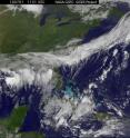
GOES-13 satellite catches Alex as a tropical storm now, after a landfall in northeastern Mexico
Alex made landfall at 10 p.m. EDT in northeastern Mexico, about 110 miles south of Brownsville, Texas. By 8 a.m. EDT on July 1, Alex has weakened to a tropical storm and GOES satellite imagery showed it moving near the high mountains of Mexico. At 8 a.m. EDT on July 1, Alex was about 55 miles (85 km) west of Ciudad Victoria, Mexico. That's near 23.8 North and 99.8 West. Its maximum sustained winds were now around 70 mph (110 km/hr) with higher gusts. Alex is moving west at 12 mph (19 km/hr) and has a minimum central pressure of 977 millibars. The Geostationary Operational Environmental Satellite that covers the U.S. east coast, called GOES-13 captured an image of Alex moving into the Mexican mountains at 1131 UTC (7:31 a.m. EDT).
GOES satellite imagery is created by NASA's GOES Project, located at NASA's Goddard Space Flight Center, Greenbelt, Md. GOES-13 is operated by the National Oceanic and Atmospheric Administration.
The government of Mexico has replaced the hurricane warning with a Tropical storm warning for the coast of Mexico from Rio San Fernando to La Cruz.
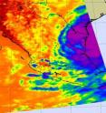
NASA's AIRS instrument aboard the Aqua satellite captured Alex on June 30 at 2017 UTC (4:17 p.m. EDT) about 6 hours before Alex's eye made landfall. At that time, the strongest thunderstorms were mostly still offshore and the infrared imagery showed that cloud tops were so high they were colder than -63 Fahrenheit.
When Alex did make landfall, it was packing maximum sustained winds near 97 mph (85 knots) and dumped 8 to 12 inches of rain on northeastern states in Mexico. The National Hurricane Center in Miami, Fla. noted that Alex will continue to be a big rainmaker. Alex is expected to produce total rainfall accumulations of 6 to 12 inches over portions of northeastern Mexico. Isolated maximum amounts of 20 inches are possible over the higher elevations of northeastern Mexico. Alex is expected to produce total rainfall accumulations of 4 to 8 inches over portions of southern Texas, with possible isolated maximum amounts around 10 inches.
In Texas, Galveston and Jamaica Beach, Texas received enough rainfall to cover the roadways last night, but the roads have already cleared this morning. Brownsville, Texas reports no wind damage, no power outages, and clear roadways. Sporadic power outages, a wind gust to 66 mph, and a storm surge of 3.44 feet were reported in South Padre Island, Texas. In Boca Chica, Texas, there was a report of a tornado touchdown at 6:45 p.m. CDT.
The system is now moving inland and weakening. Heavy rainfall is the main threat as Alex continues to weaken. Alex is expected to weaken to a tropical depression later today and dissipate in the next 24 to 36 hours.
Source: NASA/Goddard Space Flight Center
Articles on the same topic
- NASA data see Alex's core aligned, growing toward hurricane strengthTue, 29 Jun 2010, 21:24:08 UTC
- Tropical Storm Alex now in Gulf of Mexico, brought heavy rainfall to Belize, YucatanMon, 28 Jun 2010, 17:57:10 UTC
Other sources
- GOES-13 satellite catches Alex as a tropical storm now, after a landfall in northeastern Mexicofrom Science BlogThu, 1 Jul 2010, 18:14:26 UTC
- GOES-13 satellite catches Alex as a tropical storm now, after a landfall in northeastern Mexicofrom Science BlogThu, 1 Jul 2010, 18:14:24 UTC
- Pictures: Hurricane Alex Pushes Oil on "Cleaned" Beachesfrom National GeographicWed, 30 Jun 2010, 23:56:11 UTC
- Video: Weather Hinders Spill Clean Upfrom CBSNews - ScienceWed, 30 Jun 2010, 23:35:14 UTC
- Hurricane Alex Pushes "Worst Oil" Ashore; Cleanup Slowedfrom National GeographicWed, 30 Jun 2010, 22:28:09 UTC
- Hurricanes May Be Good for Gulf Oil Spill, Experts Sayfrom National GeographicWed, 30 Jun 2010, 19:07:09 UTC
- Gulf oil cleanup derailed by hurricanefrom CBC: Technology & ScienceWed, 30 Jun 2010, 17:50:31 UTC
- Alex Stirs Up the Gulffrom PhysorgWed, 30 Jun 2010, 16:35:28 UTC
- Video: Bad Weather Halts Spill Relieffrom CBSNews - ScienceWed, 30 Jun 2010, 14:35:42 UTC
- Gulf Woes Grow as Hurricane Threat Mountsfrom Live ScienceWed, 30 Jun 2010, 14:28:16 UTC
- Biden visits gulf as storm approachesfrom LA Times - ScienceWed, 30 Jun 2010, 5:21:15 UTC
- Video: Bad Weather Halts Spill Relieffrom CBSNews - ScienceWed, 30 Jun 2010, 2:28:23 UTC
- Video: Bad Weather Halts Spill Relieffrom CBSNews - ScienceWed, 30 Jun 2010, 2:07:28 UTC
- Alex Stirs Up the Gulffrom NASA Jet Propulsion LaboratoryWed, 30 Jun 2010, 0:49:06 UTC
- NASA data see Alex's core aligned, growing toward hurricane strengthfrom PhysorgTue, 29 Jun 2010, 21:22:03 UTC
- Alex "So Darn Large," But Oil-Storm Fears Unfounded?from National GeographicTue, 29 Jun 2010, 21:21:08 UTC
- Hurricane Alex: Where Will It Go and How Long Will It Last?from Live ScienceTue, 29 Jun 2010, 17:49:09 UTC
- Video: Bad Weather Halts Spill Relieffrom CBSNews - ScienceTue, 29 Jun 2010, 11:49:32 UTC
- Gulf's Tropical Storm Alex May Become Major Hurricanefrom National GeographicTue, 29 Jun 2010, 5:56:07 UTC
- Video: Bad Weather Halts Spill Relieffrom CBSNews - ScienceTue, 29 Jun 2010, 3:56:08 UTC
- Video: Bad Weather Halts Spill Relieffrom CBSNews - ScienceTue, 29 Jun 2010, 1:21:26 UTC
- Video: Bad Weather Halts Spill Relieffrom CBSNews - ScienceTue, 29 Jun 2010, 0:56:11 UTC
- Video: Bad Weather Halts Spill Relieffrom CBSNews - ScienceTue, 29 Jun 2010, 0:35:13 UTC
- Video: Bad Weather Halts Spill Relieffrom CBSNews - ScienceTue, 29 Jun 2010, 0:14:10 UTC
- Oil spill team frets about Tropical Storm Alexfrom LA Times - ScienceMon, 28 Jun 2010, 22:14:26 UTC
- Tropical Storm Alex is on the move on a day of prayer in the gulffrom LA Times - ScienceMon, 28 Jun 2010, 22:14:07 UTC
- Tropical Storm Alex now in Gulf of Mexico, brought heavy rainfall to Belize, Yucatanfrom Science BlogMon, 28 Jun 2010, 18:56:13 UTC
- Tropical Storm Alex now in Gulf of Mexico, brought heavy rainfall to Belize, Yucatanfrom PhysorgMon, 28 Jun 2010, 17:56:11 UTC
- Video: Storm Threatens Gulf Coast?from CBSNews - ScienceMon, 28 Jun 2010, 15:56:24 UTC
- Tracking Gulf Oil and Stormsfrom NY Times ScienceSun, 27 Jun 2010, 23:42:09 UTC
- Video: Storm Threatens Gulf Coast?from CBSNews - ScienceSun, 27 Jun 2010, 12:14:22 UTC
- Video: Storm Threatens Gulf Coast?from CBSNews - ScienceSun, 27 Jun 2010, 11:49:13 UTC
- Oil spill team frets about Tropical Storm Alexfrom LA Times - ScienceSun, 27 Jun 2010, 4:21:16 UTC
- Unclear if Tropical Storm Alex will hit oiled Gulffrom LA Times - ScienceSat, 26 Jun 2010, 15:56:48 UTC
- Storm theatens Gulf of Mexico oil spill clean-upfrom PhysorgSat, 26 Jun 2010, 15:07:16 UTC
- Video: Storm Threatens Gulf Coast?from CBSNews - ScienceSat, 26 Jun 2010, 12:35:45 UTC
- Video: Storm Threatens Gulf Coast?from CBSNews - ScienceSat, 26 Jun 2010, 8:49:13 UTC
- Brewing storm casts a cloud on oil spill responsefrom LA Times - ScienceSat, 26 Jun 2010, 3:14:13 UTC
- Video: Storm Threatens Gulf Coast?from CBSNews - ScienceSat, 26 Jun 2010, 1:21:18 UTC
- Video: Storm Threatens Gulf Coast?from CBSNews - ScienceSat, 26 Jun 2010, 0:56:14 UTC
- Video: Storm Threatens Gulf Coast?from CBSNews - ScienceFri, 25 Jun 2010, 23:49:10 UTC

