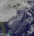
Satellite captures the life and death of Hurricane Sandy on Halloween
Hurricane Sandy is giving up the ghost on Halloween over Pennsylvania. As the storm weakened to a remnant low pressure area the NASA GOES Project released an animation of NOAA's GOES-13 satellite imagery covering Hurricane Sandy's entire life. The GOES-13 satellite is managed by the National Oceanic and Atmospheric Administration (NOAA), and NASA's GOES Project at NASA's Goddard Space Flight Center in Greenbelt, Md. creates images and animations from GOES data.
The animation of Sandy's life runs from Oct. 23 through 31. It begins when Tropical Depression 18 strengthened into Hurricane Sandy on Oct. 23, 2012. The animation shows Hurricane Sandy blowing from the Caribbean to the mid-Atlantic where it became wedged between a stationary cold front over the Appalachians and a static high pressure air mass over maritime Canada. The air masses blocked the storm from moving north or east, as it would normally. Instead, their wintery dynamics amplified Sandy and drove it ashore in the mid-Atlantic.
Sandy then became a ferocious Nor'easter that brought record storm surges to coastal N.J. and N.Y., plus blizzard conditions to the mountains. Unprecedented chaos occurred in lower New York City, such as flooding the subway system on the evening of Oct. 29. Total damage by the storm was estimated at $20 billion dollars.
NOAA's National Hydrometeorological Prediction Center (NOAA/HPC) issued an advisory at 5 a.m. EDT on Oct. 31 that stated there was "no discernible surface circulation." Sandy had weakened to a surface trough (elongated area) of low pressure over western Pennsylvania.
There are a lot of warnings and watches in effect as Sandy continues to wind down. Gale warnings and small craft advisories are in effect for portions of the great lakes. Small craft advisories are in effect along much of the Mid-Atlantic and northeast coasts.
Flood and coastal flood watches, warnings and advisories are in effect over portions of the Mid-Atlantic and northeast states. Coastal flooding along portions of the Great Lakes is also possible.
Winter storm warnings and winter weather advisories remain in effect for the mountains of southwest Pennsylvania, western Maryland, West Virginia, eastern Tennessee, eastern Kentucky, and extreme western North Carolina.
Sandy is appropriately dying on Halloween, but the storm's effects will linger for some time.
Source: NASA/Goddard Space Flight Center
Other sources
- Satellite still shows Sandy's remnant clouds over eastern Canada and the northeastern U.S.from Science DailyFri, 2 Nov 2012, 21:00:42 UTC
- Video: Life and death of Sandy from a NASA satellitefrom CBSNews - ScienceFri, 2 Nov 2012, 20:50:12 UTC
- Satellite still shows Sandy's remnant clouds over eastern Canada and the northeastern USfrom PhysorgFri, 2 Nov 2012, 20:31:20 UTC
- Sandy: A Storm with Many Faces, Many Namesfrom Live ScienceFri, 2 Nov 2012, 0:20:38 UTC
- Frankenstorm Sandy Spotted Dying Out on Halloweenfrom Space.comThu, 1 Nov 2012, 22:31:14 UTC
- NASA adds up Hurricane Sandy's rainfall from spacefrom Science DailyThu, 1 Nov 2012, 22:00:38 UTC
- Frankenstorm Sandy Spotted Dying Out on Halloweenfrom Live ScienceThu, 1 Nov 2012, 21:50:40 UTC
- Timeline of Hurricane Sandy's Week of Destruction (Infographic)from Live ScienceThu, 1 Nov 2012, 21:20:20 UTC
- NASA adds up Hurricane Sandy's rainfall from spacefrom PhysorgThu, 1 Nov 2012, 21:00:50 UTC
- News Writers: Stop Trying To Scare People With Made-Up Storm Languagefrom PopSciThu, 1 Nov 2012, 20:30:35 UTC
- Hurricane Sandy - Power Outage Prediction Model Was Accuratefrom Newswise - ScinewsThu, 1 Nov 2012, 20:01:12 UTC
- The Sandy 15? Superstorm comfort-eating on menufrom AP HealthThu, 1 Nov 2012, 18:00:44 UTC
- Robot Wave Glider Survives Hurricane Sandy at Seafrom Live ScienceThu, 1 Nov 2012, 17:20:30 UTC
- Satellite captures the life and death of Hurricane Sandy on Halloweenfrom Science DailyThu, 1 Nov 2012, 13:30:39 UTC
- Americans take to social media to help post-Sandyfrom PhysorgThu, 1 Nov 2012, 2:00:22 UTC
- Pollution & Debris Stirred by Sandy Threaten Coastal Watersfrom Live ScienceThu, 1 Nov 2012, 0:30:50 UTC
- Site helps people find open pharmacies post-Sandyfrom PhysorgThu, 1 Nov 2012, 0:30:32 UTC
- Satellite captures the life and death of Hurricane Sandy on Halloween (w/ Video)from PhysorgThu, 1 Nov 2012, 0:00:28 UTC
- US Navy Warships Offer Aid After Superstorm Sandyfrom Live ScienceWed, 31 Oct 2012, 22:30:50 UTC
- Internet usage rocketed on the East Coast during Sandy, report saysfrom CBSNews - ScienceWed, 31 Oct 2012, 19:30:46 UTC
- Sandy Lives Up to Hype: Predictions Were on Trackfrom Live ScienceWed, 31 Oct 2012, 18:30:48 UTC
- NASA Satellites Capture Hurricane Sandy’s Massive Sizefrom Science BlogWed, 31 Oct 2012, 13:30:38 UTC
- How Sandy compares to worst US natural disastersfrom MSNBC: ScienceWed, 31 Oct 2012, 4:30:40 UTC
- How Sandy compares to worst US natural disastersfrom MSNBC: ScienceTue, 30 Oct 2012, 22:30:40 UTC
- The Stats Are In: Superstorm Sandy Totalsfrom Scientific AmericanTue, 30 Oct 2012, 22:30:29 UTC
- How Sandy became a snowstormfrom CBSNews - ScienceTue, 30 Oct 2012, 19:30:20 UTC
- Huffington Post, Gawker brought down by Superstorm Sandyfrom CBSNews - ScienceTue, 30 Oct 2012, 12:31:03 UTC
- How Sandy turned into a superstormfrom MSNBC: ScienceMon, 29 Oct 2012, 16:00:58 UTC
