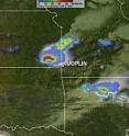
NASA's TRMM satellite saw heavy rainfall in supercell that spawned Joplin tornado
On Sunday May 22, 2011, the Tropical Rainfall Measuring Mission (TRMM) satellite captured an image of the rainfall rate in the supercell thunderstorm that generated the deadly twister that struck Joplin, Missouri. TRMM is a satellite that is managed by both NASA and the Japanese Space Agency, and monitors rainfall rates in the tropics. It's often used for hurricane research, but also calculates rain rates in other weather systems. On May 22 at 2042 UTC (3:42 p.m. CDT), about two hours before the deadly tornado touched down in Joplin, Missouri, TRMM captured rainfall rates in a supercell thunderstorm that was approaching Joplin from the west. A supercell, also known as a rotating thunderstorm, is a thunderstorm with a deep, continuously-rotating updraft.
"This supercell contained a deadly tornado as it moved into southwestern Missouri a few hours later and hit Joplin, Missouri," said Hal Pierce, meteorologist on NASA's TRMM team who created images using TRMM rainfall imagery. TRMM's Microwave Imager (TMI) and Precipitation Radar (PR) were used to create images that showed an analysis of rainfall in the vicinity of the storm. TRMM data revealed a large area of heavy rainfall, where rainfall rates were more than 2 inches (50 millimeters) per hour.
Two hours after the TRMM satellite captured that heavy rainfall, the tornado touched down in Joplin with winds up to 198 miles per hour, according to the National Weather Service. As of May 24, 117 people were reported killed, making the twister the most deadly in the U.S. in over 60 years.
Southwestern Missouri can't get a break from the severe weather as the recovery efforts continue today, May 24. The National Weather Service (NWS) in southwestern Missouri noted that "Multiple rounds of thunderstorms are expected over the region from this evening through at least Wednesday morning."
Source: NASA/Goddard Space Flight Center
Other sources
- Dot Earth: Tornadoes and Natural Gas in the Greenhousefrom NY Times ScienceWed, 25 May 2011, 20:20:16 UTC
- NASA's TRMM satellite saw heavy rainfall in supercell that spawned Joplin, Missouri tornadofrom Science DailyWed, 25 May 2011, 18:30:47 UTC
- GOES-13 satellite video close-up of deadly Joplin, Missouri tornadofrom PhysorgWed, 25 May 2011, 15:00:26 UTC
- NASA's TRMM satellite saw heavy rainfall in supercell that spawned Joplin tornadofrom PhysorgWed, 25 May 2011, 14:00:27 UTC
- Explaining the science of this spring's tornadoesfrom LA Times - ScienceWed, 25 May 2011, 3:00:30 UTC
- Deadly U.S. tornadoes likely not sign of escalating storm trendfrom CBC: Technology & ScienceTue, 24 May 2011, 23:30:20 UTC
- Terrifying Joplin Supercell Tornado Seen from Spacefrom Space.comTue, 24 May 2011, 17:00:33 UTC
- Terrifying Joplin Supercell Tornado Seen from Spacefrom Live ScienceTue, 24 May 2011, 17:00:27 UTC
- Repeat deadly storms 'unusual but not unknown'from PhysorgTue, 24 May 2011, 16:02:15 UTC
- Experts: Multiple killer tornados "unusual but not unknown"from CBSNews - ScienceTue, 24 May 2011, 16:00:47 UTC
- Green: A Q-and-A on Tornadoesfrom NY Times ScienceTue, 24 May 2011, 15:00:19 UTC
- Repeat deadly storms 'unusual but not unknown'from AP ScienceTue, 24 May 2011, 14:00:27 UTC
- Are tornadoes more common because of climate change?from The Guardian - ScienceTue, 24 May 2011, 9:30:29 UTC
- Joplin, Missouri, Tornado Pictures: "WWII" Devastationfrom National GeographicMon, 23 May 2011, 22:30:16 UTC
- Why no tornado safety building codes?from MSNBC: ScienceMon, 23 May 2011, 22:00:17 UTC
- Joplin, Missouri, Tornado Strong but Not Surprising?from National GeographicMon, 23 May 2011, 21:30:30 UTC
- No link between tornadoes and climate change: USfrom PhysorgMon, 23 May 2011, 20:31:25 UTC
- Joplin tornado came on with terrifying speedfrom MSNBC: ScienceMon, 23 May 2011, 20:31:10 UTC
- Joplin tornado came with terrifying speedfrom MSNBC: ScienceMon, 23 May 2011, 20:00:19 UTC
- Joplin tornado came with terrifying speedfrom MSNBC: ScienceMon, 23 May 2011, 18:30:42 UTC
- Tornado Grew with Rare Speed on Way to Joplinfrom Live ScienceMon, 23 May 2011, 17:00:35 UTC
- VIDEO: Missouri tornado caught on camerafrom BBC News: Science & NatureMon, 23 May 2011, 13:40:19 UTC
