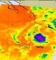
Celia and Darby are now both weakening tropical storms
The Eastern Pacific twins, Darby and Celia were once both major hurricanes and today are just barely hanging on to tropical storm status. Both are forecast to continue weakening over the next day or two. Celia is spinning farthest away from land in the Eastern Pacific and seems to be sitting still. At 5 a.m. EDT on Monday, June 28, Celia was located about 1070 miles (1720 km) west-southwest of the southern tip of Baja California. Celia is virtually stationary, moving only 2 mph (4 km/hr) to the southwest. Celia's maximum sustained winds were near 40 mph, but she expected to weaken and become a remnant low pressure area over the next day or two. Minimum central pressure is 1005 millibars.
Tropical Storm Darby is closer to the western Mexico coast, about 240 miles (390 km) south of Zihuatanejo, Mexico, near 14.2 North and 101.4 West. Darby's maximum sustained winds were also near 40 mph, but like Celia, Darby is expected to weaken to a remnant low pressure area by sometime on Tuesday. Darby is moving east-northeast toward the Mexican coast at 6 mph (9 km/hr) although no watches or warnings are posted for this storm. Current minimum central pressure is 1004 millibars.
NASA's Aqua satellite passed over Celia and Darby on June 25, and NASA's Moderate Resolution Imaging Spectroradiometer (MODIS) instrument captured visible images of each storm. The MODIS team at NASA's Goddard Space Flight Center in Greenbelt, Md. created a mosaic of images from that data, and they can be found at: http://rapidfire.sci.gsfc.nasa.gov/gallery/?2010176-0625/CeliaDarby.A2010176.2140.
By Wednesday, the tropical twins should both be remnant low pressure areas in the Eastern Pacific.
Source: NASA/Goddard Space Flight Center
Articles on the same topic
- GOES satellite sees Celia's remnants a shadow of her former selfTue, 29 Jun 2010, 19:29:23 UTC
- NASA infrared imagery shows well-defined eye in Category 5 CeliaFri, 25 Jun 2010, 20:46:03 UTC
- GOES-13 captures 2 major hurricanes: Darby trailing CeliaFri, 25 Jun 2010, 20:23:32 UTC
- Celia now in the Major Leagues: a category three hurricaneThu, 24 Jun 2010, 21:22:45 UTC
- NASA satellites see Hurricane Celia strengthen and open an eyeWed, 23 Jun 2010, 19:03:48 UTC
- NASA's TRMM satellite sees Hurricane Celia's moderate rainfallTue, 22 Jun 2010, 16:05:43 UTC
Other sources
- Celia and Darby are now both weakening tropical stormsfrom Science BlogMon, 28 Jun 2010, 18:56:15 UTC
- Celia and Darby are now both weakening tropical stormsfrom PhysorgMon, 28 Jun 2010, 18:21:12 UTC
- NASA infrared imagery shows well-defined eye in Category 5 Celiafrom PhysorgFri, 25 Jun 2010, 23:14:09 UTC
- GOES-13 captures 2 major hurricanes: Darby trailing Celiafrom PhysorgFri, 25 Jun 2010, 22:49:09 UTC
- NASA infrared imagery shows well-defined eye in Category 5 Celiafrom Science BlogFri, 25 Jun 2010, 21:49:22 UTC
- NASA infrared imagery shows well-defined eye in Category 5 Celiafrom Science BlogFri, 25 Jun 2010, 21:49:19 UTC
- GOES-13 captures 2 major hurricanes: Darby trailing Celiafrom Science BlogFri, 25 Jun 2010, 21:49:14 UTC
- GOES-13 captures 2 major hurricanes: Darby trailing Celiafrom Science BlogFri, 25 Jun 2010, 21:49:13 UTC
- Celia now in the Major Leagues: a category three hurricanefrom PhysorgThu, 24 Jun 2010, 21:00:22 UTC
- NASA satellites see Hurricane Celia strengthen and open an eyefrom Science BlogWed, 23 Jun 2010, 21:02:01 UTC
- NASA satellites see Hurricane Celia strengthen and open an eyefrom PhysorgWed, 23 Jun 2010, 20:00:39 UTC
- NASA's TRMM satellite sees Hurricane Celia's moderate rainfallfrom PhysorgTue, 22 Jun 2010, 16:03:23 UTC
