NASA infrared imagery shows well-defined eye in Category 5 Celia
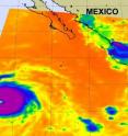
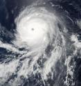
Celia has exploded into a monster hurricane in the Eastern Pacific, and is now a Category 5 storm over open waters. NASA's Aqua satellite captured an infrared image (that shows temperature) of Celia's clouds and clearly shows an eye in the storm. Celia's eye appears well-defined and is between 15-20 nautical miles wide. The Atmospheric Infrared Sounder, or AIRS instrument provides infrared imagery of cloud tops and sea surface temperatures, two things that are important to tropical cyclones. High, cold cloud tops indicate strong thunderstorms around a tropical cyclone's center. AIRS imagery on June 25 noticed that Celia had a very large area of high, icy cold clouds that are so very high in the troposphere (to the tropopause) that they're as cold as -94 to -112 (-75 to -80 Celsius) Fahrenheit! The National Hurricane Center called Celia a "very impressive hurricane" this morning.
Warm sea surface temperatures are also critical for a tropical cyclone's development, and AIRS infrared imagery is able to read those temperatures from space, too. AIRS imagery taken on Friday, July 25 at 9:05 UTC (5:05 a.m. EDT) showed that the sea surface temperatures around Celia were over the 80 degree Fahrenheit threshold needed to continue powering tropical cyclones. As Celia continues to move west-northwestward, however, those waters will become cooler and they are expected to weaken Celia.
At 5 a.m. EDT (2 a.m. PDT) on Friday, June 25, powerful Category Five Hurricane Celia was packing maximum sustained winds near 160 mph (260 km/hr). Hurricane force winds extend outward up to 50 miles (85 km) from the center...and tropical storm force winds extend outward up to 140 miles (220 km). Celia's center was located about 805 nautical miles southwest of the southern tip of Baja California, near 13.4 North and 117.0 West. Celia's minimum central pressure is 926 millibars, and she is moving west-northwest near 13 mph (20 km/hr).
The cooler waters that lie in Celia's path are expected to quickly help weaken the storm. The National Hurricane Center expects Celia to be downgraded to tropical storm strength late on Sunday, June 27.
Source: NASA/Goddard Space Flight Center
Articles on the same topic
- GOES satellite sees Celia's remnants a shadow of her former selfTue, 29 Jun 2010, 19:29:23 UTC
- Celia and Darby are now both weakening tropical stormsMon, 28 Jun 2010, 17:57:07 UTC
- GOES-13 captures 2 major hurricanes: Darby trailing CeliaFri, 25 Jun 2010, 20:23:32 UTC
- Celia now in the Major Leagues: a category three hurricaneThu, 24 Jun 2010, 21:22:45 UTC
- NASA satellites see Hurricane Celia strengthen and open an eyeWed, 23 Jun 2010, 19:03:48 UTC
- NASA's TRMM satellite sees Hurricane Celia's moderate rainfallTue, 22 Jun 2010, 16:05:43 UTC
Other sources
- Celia and Darby are now both weakening tropical stormsfrom Science BlogMon, 28 Jun 2010, 18:56:15 UTC
- Celia and Darby are now both weakening tropical stormsfrom PhysorgMon, 28 Jun 2010, 18:21:12 UTC
- NASA infrared imagery shows well-defined eye in Category 5 Celiafrom PhysorgFri, 25 Jun 2010, 23:14:09 UTC
- GOES-13 captures 2 major hurricanes: Darby trailing Celiafrom PhysorgFri, 25 Jun 2010, 22:49:09 UTC
- NASA infrared imagery shows well-defined eye in Category 5 Celiafrom Science BlogFri, 25 Jun 2010, 21:49:22 UTC
- NASA infrared imagery shows well-defined eye in Category 5 Celiafrom Science BlogFri, 25 Jun 2010, 21:49:19 UTC
- GOES-13 captures 2 major hurricanes: Darby trailing Celiafrom Science BlogFri, 25 Jun 2010, 21:49:14 UTC
- GOES-13 captures 2 major hurricanes: Darby trailing Celiafrom Science BlogFri, 25 Jun 2010, 21:49:13 UTC
- Celia now in the Major Leagues: a category three hurricanefrom PhysorgThu, 24 Jun 2010, 21:00:22 UTC
- NASA satellites see Hurricane Celia strengthen and open an eyefrom Science BlogWed, 23 Jun 2010, 21:02:01 UTC
- NASA satellites see Hurricane Celia strengthen and open an eyefrom PhysorgWed, 23 Jun 2010, 20:00:39 UTC
- NASA's TRMM satellite sees Hurricane Celia's moderate rainfallfrom PhysorgTue, 22 Jun 2010, 16:03:23 UTC

