Celia now in the Major Leagues: a category three hurricane
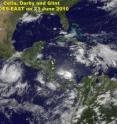
Tropically speaking Celia is in the Major Leagues. She's now a Category Three hurricane on the Saffir-Simpson hurricane scale and classified as the Eastern Pacific's first major hurricane. That's quite a "batting average" for also being that season's first hurricane. The other storms that formed before her in the Eastern Pacific didn't make it to hurricane status. Both Geostationary Operational Environmental Satellites, GOES-11 (west) and GOES-13 (east) captured visible images of Hurricane Celia and Tropical Storm Darby in the Eastern Pacific on June 23, and Celia's eye was visible in them.
At 8 a.m. PDT (11 a.m. EDT) on June 24, Hurricane Celia's maximum sustained winds were near 115 mph (185 km/hr) with higher gusts. Hurricane force winds extend outward up to 30 miles (45 km) from the center and tropical storm force winds extend outward up to 115 miles (185 km).
She was located in the open waters of the Eastern Pacific Ocean near latitude 12.5 north and longitude 113.9 west. Minimum central pressure is 962 millibars. Celia is moving toward the west near 13 mph (20 km/hr) and a turn toward the west-northwest is expected over the next couple of days. Some additional strengthening is possible later today, followed by gradual weakening on Friday.
Celia's eye has appeared to be "blinking" over the last couple of days because it has been visible in some satellite imagery, then not visible. This morning, June 24, satellite imagery sees the open eye again.
Although the upper level winds appear favorable to keep Celia going, she's moving into cooler sea surface temperatures near 26-27 Celsius (78-80 Fahrenheit) and cooler as she continues tracking farther into open waters. Tropical cyclones require sea surface temperatures at least near 80 degrees Fahrenheit to maintain their intensity, so Celia will start weakening soon because one of her "power sources" (warm water) will be removed. Those cooler waters will send Celia back into the "minor leagues" by the weekend.
Source: NASA/Goddard Space Flight Center
Articles on the same topic
- GOES satellite sees Celia's remnants a shadow of her former selfTue, 29 Jun 2010, 19:29:23 UTC
- Celia and Darby are now both weakening tropical stormsMon, 28 Jun 2010, 17:57:07 UTC
- NASA infrared imagery shows well-defined eye in Category 5 CeliaFri, 25 Jun 2010, 20:46:03 UTC
- GOES-13 captures 2 major hurricanes: Darby trailing CeliaFri, 25 Jun 2010, 20:23:32 UTC
- NASA satellites see Hurricane Celia strengthen and open an eyeWed, 23 Jun 2010, 19:03:48 UTC
- NASA's TRMM satellite sees Hurricane Celia's moderate rainfallTue, 22 Jun 2010, 16:05:43 UTC
Other sources
- Celia and Darby are now both weakening tropical stormsfrom Science BlogMon, 28 Jun 2010, 18:56:15 UTC
- Celia and Darby are now both weakening tropical stormsfrom PhysorgMon, 28 Jun 2010, 18:21:12 UTC
- NASA infrared imagery shows well-defined eye in Category 5 Celiafrom PhysorgFri, 25 Jun 2010, 23:14:09 UTC
- GOES-13 captures 2 major hurricanes: Darby trailing Celiafrom PhysorgFri, 25 Jun 2010, 22:49:09 UTC
- NASA infrared imagery shows well-defined eye in Category 5 Celiafrom Science BlogFri, 25 Jun 2010, 21:49:22 UTC
- NASA infrared imagery shows well-defined eye in Category 5 Celiafrom Science BlogFri, 25 Jun 2010, 21:49:19 UTC
- GOES-13 captures 2 major hurricanes: Darby trailing Celiafrom Science BlogFri, 25 Jun 2010, 21:49:14 UTC
- GOES-13 captures 2 major hurricanes: Darby trailing Celiafrom Science BlogFri, 25 Jun 2010, 21:49:13 UTC
- Celia now in the Major Leagues: a category three hurricanefrom PhysorgThu, 24 Jun 2010, 21:00:22 UTC
- NASA satellites see Hurricane Celia strengthen and open an eyefrom Science BlogWed, 23 Jun 2010, 21:02:01 UTC
- NASA satellites see Hurricane Celia strengthen and open an eyefrom PhysorgWed, 23 Jun 2010, 20:00:39 UTC
- NASA's TRMM satellite sees Hurricane Celia's moderate rainfallfrom PhysorgTue, 22 Jun 2010, 16:03:23 UTC
