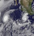
GOES-13 captures 2 major hurricanes: Darby trailing Celia
There are now two major hurricanes in the Eastern Pacific Ocean and they appear to be chasing each other in imagery from the GOES-13 satellite. Hurricane Celia is a Category Five hurricane on the Saffir-Simpson Scale, and Hurricane Darby to Celia's east has just become a Category Three hurricane (a major hurricane). The Geostationary Operational Environmental Satellite called GOES-13 captured a visible image of both the Category 5 Hurricane Celia and the Category 3 Hurricane Darby (located to Celia's southeast). In the satellite image from June 25 at 14:45 UTC (10:45 a.m. EDT) Celia had the larger eye of the two hurricanes.
The satellite image was created by NASA's GOES Project, located at NASA's Goddard Space Flight Center, Greenbelt, Md. GOES-11 is operated by the National Oceanic and Atmospheric Administration.
On Friday, June 23, at 11 a.m. EDT, Darby was classified as a major hurricane by the National Hurricane Center (NHC) as it had maximum sustained winds near 115 mph (185 km/hr). Darby was about 245 miles (395 km) south-southwest of Acapulco, Mexico, near 13.6 North and 101.2 West.
Darby was moving west-northwest near 7 mph (11 km/hr), although the NHC expects that to change over the weekend. NHC expects Darby to dip to the south then curve back toward the east by early next week while weakening. Darby's minimum central pressure is near 962 millibars.
Although Darby doesn't pose a threat to any land areas over the weekend, residents of western Mexico, including the Acapulco area, should closely monitor the track of this storm. Based on the National Hurricane Center's forecast track map, Darby could bring the western Mexican coast some rainfall and gusty winds by early next week.
Source: NASA/Goddard Space Flight Center
Articles on the same topic
- GOES satellite sees Celia's remnants a shadow of her former selfTue, 29 Jun 2010, 19:29:23 UTC
- Celia and Darby are now both weakening tropical stormsMon, 28 Jun 2010, 17:57:07 UTC
- NASA infrared imagery shows well-defined eye in Category 5 CeliaFri, 25 Jun 2010, 20:46:03 UTC
- Celia now in the Major Leagues: a category three hurricaneThu, 24 Jun 2010, 21:22:45 UTC
- NASA satellites see Hurricane Celia strengthen and open an eyeWed, 23 Jun 2010, 19:03:48 UTC
- NASA's TRMM satellite sees Hurricane Celia's moderate rainfallTue, 22 Jun 2010, 16:05:43 UTC
Other sources
- Celia and Darby are now both weakening tropical stormsfrom Science BlogMon, 28 Jun 2010, 18:56:15 UTC
- Celia and Darby are now both weakening tropical stormsfrom PhysorgMon, 28 Jun 2010, 18:21:12 UTC
- NASA infrared imagery shows well-defined eye in Category 5 Celiafrom PhysorgFri, 25 Jun 2010, 23:14:09 UTC
- GOES-13 captures 2 major hurricanes: Darby trailing Celiafrom PhysorgFri, 25 Jun 2010, 22:49:09 UTC
- NASA infrared imagery shows well-defined eye in Category 5 Celiafrom Science BlogFri, 25 Jun 2010, 21:49:22 UTC
- NASA infrared imagery shows well-defined eye in Category 5 Celiafrom Science BlogFri, 25 Jun 2010, 21:49:19 UTC
- GOES-13 captures 2 major hurricanes: Darby trailing Celiafrom Science BlogFri, 25 Jun 2010, 21:49:14 UTC
- GOES-13 captures 2 major hurricanes: Darby trailing Celiafrom Science BlogFri, 25 Jun 2010, 21:49:13 UTC
- Celia now in the Major Leagues: a category three hurricanefrom PhysorgThu, 24 Jun 2010, 21:00:22 UTC
- NASA satellites see Hurricane Celia strengthen and open an eyefrom Science BlogWed, 23 Jun 2010, 21:02:01 UTC
- NASA satellites see Hurricane Celia strengthen and open an eyefrom PhysorgWed, 23 Jun 2010, 20:00:39 UTC
- NASA's TRMM satellite sees Hurricane Celia's moderate rainfallfrom PhysorgTue, 22 Jun 2010, 16:03:23 UTC
