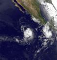
NASA satellites see Hurricane Celia strengthen and open an eye
Hurricane Celia dropped to a Category One hurricane during the late afternoon hours on June 22, and today, June 23 by 11 a.m. EDT, it had powered back up to a Category Two hurricane in the Eastern Pacific Ocean. Satellite imagery confirmed the strengthening visibly with the emergence of an eye in the hurricane. Celia's maximum sustained winds were up to 100 mph at 11 a.m. EDT on June 23. That's a jump from the 80 mph maximum sustained winds it had just six hours earlier. Celia's hurricane force winds extend outward up to 30 miles (45 km) from the center and tropical storm force winds extend outward up to 105 miles (165 km). Imagery taken this morning at 8 a.m. EDT from the Geostationary Operational Environmental Satellite known as GOES-11 revealed that Celia has an eye. The image also showed the newly formed Tropical Storm Darby to the east of Celia. The satellite image was created by NASA's GOES Project, located at NASA's Goddard Space Flight Center, Greenbelt, Md. GOES-11 is operated by the National Oceanic and Atmospheric Administration.
Two days ago on Monday, June 21, NASA's Aqua satellite flew over Celia and the Moderate Resolution Imaging Spectroradiometer (MODIS) instrument captured a true-color image of Celia that did not show an eye.
Currently, Celia is far from Mexico, some 740 miles south of the southern tip of Baja California, near 12.2 North latitude and 109.2 West longitude. Celia is moving west near 12 mph (19 km/hr) and has a minimum central pressure near 974 millibars. Celia is expected to turn toward the west-northwest in the next day or two and possibly strengthen.
Vertical wind shear is decreasing which has enabled Celia to strengthen. The National Hurricane Center in Miami, Fla. forecasts wind shear near Celia to continue weakening as low or lower than 6 mph (5 knots), which will enable Celia to strengthen a little more over the next 24 to 36 hours. However, Celia will also track into cooler waters, which will limit it's ability to power up, and as it continues west-northwest, it will begin weakening.
Source: NASA/Goddard Space Flight Center
Articles on the same topic
- GOES satellite sees Celia's remnants a shadow of her former selfTue, 29 Jun 2010, 19:29:23 UTC
- Celia and Darby are now both weakening tropical stormsMon, 28 Jun 2010, 17:57:07 UTC
- NASA infrared imagery shows well-defined eye in Category 5 CeliaFri, 25 Jun 2010, 20:46:03 UTC
- GOES-13 captures 2 major hurricanes: Darby trailing CeliaFri, 25 Jun 2010, 20:23:32 UTC
- Celia now in the Major Leagues: a category three hurricaneThu, 24 Jun 2010, 21:22:45 UTC
- NASA's TRMM satellite sees Hurricane Celia's moderate rainfallTue, 22 Jun 2010, 16:05:43 UTC
Other sources
- Celia and Darby are now both weakening tropical stormsfrom Science BlogMon, 28 Jun 2010, 18:56:15 UTC
- Celia and Darby are now both weakening tropical stormsfrom PhysorgMon, 28 Jun 2010, 18:21:12 UTC
- NASA infrared imagery shows well-defined eye in Category 5 Celiafrom PhysorgFri, 25 Jun 2010, 23:14:09 UTC
- GOES-13 captures 2 major hurricanes: Darby trailing Celiafrom PhysorgFri, 25 Jun 2010, 22:49:09 UTC
- NASA infrared imagery shows well-defined eye in Category 5 Celiafrom Science BlogFri, 25 Jun 2010, 21:49:22 UTC
- NASA infrared imagery shows well-defined eye in Category 5 Celiafrom Science BlogFri, 25 Jun 2010, 21:49:19 UTC
- GOES-13 captures 2 major hurricanes: Darby trailing Celiafrom Science BlogFri, 25 Jun 2010, 21:49:14 UTC
- GOES-13 captures 2 major hurricanes: Darby trailing Celiafrom Science BlogFri, 25 Jun 2010, 21:49:13 UTC
- Celia now in the Major Leagues: a category three hurricanefrom PhysorgThu, 24 Jun 2010, 21:00:22 UTC
- NASA satellites see Hurricane Celia strengthen and open an eyefrom Science BlogWed, 23 Jun 2010, 21:02:01 UTC
- NASA satellites see Hurricane Celia strengthen and open an eyefrom PhysorgWed, 23 Jun 2010, 20:00:39 UTC
- NASA's TRMM satellite sees Hurricane Celia's moderate rainfallfrom PhysorgTue, 22 Jun 2010, 16:03:23 UTC
