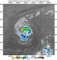
NASA sees Darby's strongest storms north of center
Infrared data NASA's Aqua satellite showed that the strongest storms within Tropical Storm Darby were occurring north of the center when it passed overhead. On July 21, 2016 at 1125 UTC (7:25 a.m. EST) the MODIS or Moderate Resolution Imaging Spectroradiometer instrument aboard NASA's Aqua satellite saw coldest cloud top temperatures between minus 60 and 70 degrees Fahrenheit/ minus 51.2 to minus 56.6 degrees Celsius indicating strong storms remained north of Darby's center. Storms with cloud tops that cold and high in the troposphere have been shown to generate heavy rainfall.
NOAA's Central Pacific Hurricane Center (CPHC) that forecasts tropical cyclones in the Central Pacific Ocean noted today "The satellite cloud pattern around Darby remains well-organized, but the area of cold tops has decreased a bit since last evening. Microwave passes at 1059 and 1156 UTC also showed good banding wrapping from west through south through east through north of the center."
At 5 a.m. HST (11 a.m. EDT/1500 UTC), the center of Tropical Storm Darby was located near latitude 18.9 North, longitude 145.2 West. That's about 645 miles (1,040 km) east of Hilo, Hawaii. Darby is moving toward the west-southwest near 15 mph (24 kph). Darby will gradually turn toward the west with a slight decrease in forward speed over the next 48 hours. Maximum sustained winds are near 65 mph (100 kph) and CPHC expects little change in strength during the next 48 hours.
Although there are no coastal watches or warnings in effect the CPHC cautions that interests in the Hawaiian Islands should monitor the progress of Darby.
Source: NASA/Goddard Space Flight Center
Articles on the same topic
- GPM measured heavy rain in Tropical Storm EstelleThu, 21 Jul 2016, 17:26:09 UTC
- Hurricane Darby weakens on approach to Central Pacific OceanWed, 20 Jul 2016, 18:29:58 UTC
- NASA sees a weaker Hurricane Darby in infrared lightWed, 20 Jul 2016, 18:29:47 UTC
- NASA looks at Hurricane Darby's cloud-filled eye, windsWed, 20 Jul 2016, 18:29:38 UTC
- NASA's SMAP Observatory looks at Tropical Storm Estelle's windsWed, 20 Jul 2016, 17:55:17 UTC
- NASA's Aqua satellite sees an almost symmetrical Tropical Storm EstelleTue, 19 Jul 2016, 15:06:41 UTC
- Satellite spots remnants of Ex-Tropical Cyclone CeliaMon, 18 Jul 2016, 18:34:35 UTC
- NASA sees the hint of an eye in Tropical Storm EstelleMon, 18 Jul 2016, 17:04:50 UTC
- NASA satellites see weaker Tropical Storm Celia move into central PacificFri, 15 Jul 2016, 16:54:29 UTC
- Satellite sees Tropical Depression 6E form in Eastern PacificFri, 15 Jul 2016, 16:54:20 UTC
- NASA finds wind shear affecting Tropical Storm CeliaThu, 14 Jul 2016, 18:04:59 UTC
- NASA looks into Tropical Cyclone Celia's winds and rainfall ratesWed, 13 Jul 2016, 21:24:53 UTC
- NASA looks at a strengthening Tropical Storm DarbyWed, 13 Jul 2016, 21:24:47 UTC
- Satellite movie shows Tropical Cyclone Blas fadingMon, 11 Jul 2016, 17:35:11 UTC
- Satellite sees Hurricane Celia moving away from MexicoMon, 11 Jul 2016, 17:35:02 UTC
- Early daylight satellite image shows depression intensify into Tropical Storm CeliaMon, 11 Jul 2016, 17:34:52 UTC
Other sources
- NASA sees Darby's strongest storms north of centerfrom PhysorgThu, 21 Jul 2016, 18:51:22 UTC
- Hurricane Darby weakens on approach to Central Pacific Oceanfrom PhysorgWed, 20 Jul 2016, 18:21:28 UTC
- SMAP Observatory looks at Tropical Storm Estelle's windsfrom PhysorgWed, 20 Jul 2016, 18:21:25 UTC
- NASA sees a weaker Hurricane Darby in infrared lightfrom PhysorgTue, 19 Jul 2016, 15:31:21 UTC
- NASA's Aqua satellite sees an almost symmetrical Tropical Storm Estellefrom PhysorgTue, 19 Jul 2016, 15:31:19 UTC
- Satellite spots remnants of Ex-Tropical Cyclone Celiafrom PhysorgMon, 18 Jul 2016, 19:01:34 UTC
- NASA looks at Hurricane Darby's cloud-filled eye, windsfrom PhysorgMon, 18 Jul 2016, 17:31:32 UTC
- NASA sees the hint of an eye in Tropical Storm Estellefrom PhysorgMon, 18 Jul 2016, 17:31:27 UTC
- NASA satellites see weaker Tropical Storm Celia move into central Pacificfrom PhysorgFri, 15 Jul 2016, 17:21:07 UTC
- Satellite sees Tropical Depression 6E form in Eastern Pacificfrom PhysorgFri, 15 Jul 2016, 17:21:06 UTC
- NASA finds wind shear affecting Tropical Storm Celiafrom PhysorgThu, 14 Jul 2016, 19:31:13 UTC
- NASA looks into Tropical Cyclone Celia's winds and rainfall ratesfrom PhysorgWed, 13 Jul 2016, 20:48:28 UTC
- NASA looks at a strengthening Tropical Storm Darbyfrom PhysorgWed, 13 Jul 2016, 20:48:26 UTC
- Satellite sees Hurricane Celia moving away from Mexicofrom PhysorgMon, 11 Jul 2016, 17:31:33 UTC
- Satellite movie shows Tropical Cyclone Blas fadingfrom PhysorgMon, 11 Jul 2016, 17:31:30 UTC
- Early daylight satellite image shows depression intensify into Tropical Storm Celiafrom PhysorgFri, 8 Jul 2016, 18:11:04 UTC
