NASA looks at Hurricane Darby's cloud-filled eye, winds
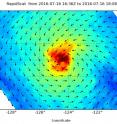
NASA satellite imagery revealed a cloud-filled eye in a weaker Hurricane Darby. Although obscured by clouds in previous days, the eye was apparent in wind data from NASA's RapidScat instrument. On July 16, NASA's RapidScat instrument measured the surface winds around Hurricane Darby and found the strongest winds all around the storm with the exception of the southwestern quadrant. Sustained winds were greater than 30 meters per second (67 mph/108 kph).
RapidScat flies aboard the International Space Station and is helpful to forecasters because it shows where the strongest winds are in the storm (winds are not evenly distributed).
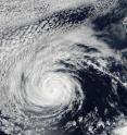
On July 17 at 09:30 UTC (5:30 a.m. EDT), the Visible Infrared Imaging Radiometer Suite (VIIRS) instrument aboard the Suomi NPP satellite captured an image of Hurricane Darby. The VIIRS image showed cloud-filled eye surrounded by a ring of powerful thunderstorms, and bands of thunderstorms wrapping into the low-level center.
The Suomi NPP satellite is managed by NASA and NOAA with support from the U.S. Department of Defense.
At 5 a.m. EDT (0900 UTC) on Monday, July 18, the center of Hurricane Darby was located near latitude 18.5 north and longitude 130.2 west. That's about 1,345 miles (2,165 km) west of the southern tip of Baja California, Mexico. Darby is moving toward the west near 10 mph (17 kph). NOAA's National Hurricane Center (NHC) said that a westward to west-northwestward motion at a slightly faster forward speed is expected during the next couple of days. Maximum sustained winds have decreased to near 80 mph (130 kph) with higher gusts.
NHC forecaster Roberts noted that "Deep convection associated with Darby continues to diminish this morning with a couple of thin, fragmented curved bands located just to the southwest of the center of circulation."
NHC said additional weakening is forecast during the next 48 hours, and Darby should become a tropical storm later today. For updated forecasts on Darby, visit: http://www.nhc.noaa.gov.
Source: NASA/Goddard Space Flight Center
Articles on the same topic
- GPM measured heavy rain in Tropical Storm EstelleThu, 21 Jul 2016, 17:26:09 UTC
- NASA sees Darby's strongest storms north of centerThu, 21 Jul 2016, 17:25:58 UTC
- Hurricane Darby weakens on approach to Central Pacific OceanWed, 20 Jul 2016, 18:29:58 UTC
- NASA sees a weaker Hurricane Darby in infrared lightWed, 20 Jul 2016, 18:29:47 UTC
- NASA's SMAP Observatory looks at Tropical Storm Estelle's windsWed, 20 Jul 2016, 17:55:17 UTC
- NASA's Aqua satellite sees an almost symmetrical Tropical Storm EstelleTue, 19 Jul 2016, 15:06:41 UTC
- Satellite spots remnants of Ex-Tropical Cyclone CeliaMon, 18 Jul 2016, 18:34:35 UTC
- NASA sees the hint of an eye in Tropical Storm EstelleMon, 18 Jul 2016, 17:04:50 UTC
- NASA satellites see weaker Tropical Storm Celia move into central PacificFri, 15 Jul 2016, 16:54:29 UTC
- Satellite sees Tropical Depression 6E form in Eastern PacificFri, 15 Jul 2016, 16:54:20 UTC
- NASA finds wind shear affecting Tropical Storm CeliaThu, 14 Jul 2016, 18:04:59 UTC
- NASA looks into Tropical Cyclone Celia's winds and rainfall ratesWed, 13 Jul 2016, 21:24:53 UTC
- NASA looks at a strengthening Tropical Storm DarbyWed, 13 Jul 2016, 21:24:47 UTC
- Satellite movie shows Tropical Cyclone Blas fadingMon, 11 Jul 2016, 17:35:11 UTC
- Satellite sees Hurricane Celia moving away from MexicoMon, 11 Jul 2016, 17:35:02 UTC
- Early daylight satellite image shows depression intensify into Tropical Storm CeliaMon, 11 Jul 2016, 17:34:52 UTC
Other sources
- NASA sees Darby's strongest storms north of centerfrom PhysorgThu, 21 Jul 2016, 18:51:22 UTC
- Hurricane Darby weakens on approach to Central Pacific Oceanfrom PhysorgWed, 20 Jul 2016, 18:21:28 UTC
- SMAP Observatory looks at Tropical Storm Estelle's windsfrom PhysorgWed, 20 Jul 2016, 18:21:25 UTC
- NASA sees a weaker Hurricane Darby in infrared lightfrom PhysorgTue, 19 Jul 2016, 15:31:21 UTC
- NASA's Aqua satellite sees an almost symmetrical Tropical Storm Estellefrom PhysorgTue, 19 Jul 2016, 15:31:19 UTC
- Satellite spots remnants of Ex-Tropical Cyclone Celiafrom PhysorgMon, 18 Jul 2016, 19:01:34 UTC
- NASA looks at Hurricane Darby's cloud-filled eye, windsfrom PhysorgMon, 18 Jul 2016, 17:31:32 UTC
- NASA sees the hint of an eye in Tropical Storm Estellefrom PhysorgMon, 18 Jul 2016, 17:31:27 UTC
- NASA satellites see weaker Tropical Storm Celia move into central Pacificfrom PhysorgFri, 15 Jul 2016, 17:21:07 UTC
- Satellite sees Tropical Depression 6E form in Eastern Pacificfrom PhysorgFri, 15 Jul 2016, 17:21:06 UTC
- NASA finds wind shear affecting Tropical Storm Celiafrom PhysorgThu, 14 Jul 2016, 19:31:13 UTC
- NASA looks into Tropical Cyclone Celia's winds and rainfall ratesfrom PhysorgWed, 13 Jul 2016, 20:48:28 UTC
- NASA looks at a strengthening Tropical Storm Darbyfrom PhysorgWed, 13 Jul 2016, 20:48:26 UTC
- Satellite sees Hurricane Celia moving away from Mexicofrom PhysorgMon, 11 Jul 2016, 17:31:33 UTC
- Satellite movie shows Tropical Cyclone Blas fadingfrom PhysorgMon, 11 Jul 2016, 17:31:30 UTC
- Early daylight satellite image shows depression intensify into Tropical Storm Celiafrom PhysorgFri, 8 Jul 2016, 18:11:04 UTC

