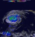
GPM measured heavy rain in Tropical Storm Estelle
The Global Precipitation Measurement mission or GPM core observatory satellite traveled above tropical storm Estelle and found heavy rainfall occurring on its eastern side. That heavy area of rainfall was later found west of center. Heavy rainfall within a tropical cyclone can shift as the storm continues to change. Such was the case with Estelle.
On July 19, 2016 at 1036 UTC (6:36 a.m. EDT) when GPM passed over the storm, Estelle contained well organized convective bands of thunderstorms that were producing heavy rainfall within the storm. Precipitation within Estelle was analyzed using data collected by GPM's Microwave Imager (GMI) and Dual-Frequency Precipitation Radar (DPR) instruments. GPM's radar (DPR Ku band) data were used to perform a 3-D examination of the precipitation on the eastern side of tropical storm Estelle. Some rainfall was measured by DPR falling at a rate of over 65 mm (2.6 inches) per hour in storms in that area.
DPR's 3-D scans of Estelle found that some storm top heights were reaching to above 11.6 km (7.2 miles) on the eastern side of the tropical storm. An animation of DPR 3-D slices were also used to show radar reflectivity values of precipitation on the eastern side of the storm.
GPM is a joint mission between NASA and the Japan Aerospace Exploration Agency.
At 11 a.m. EDT (1500 UTC) on Thursday, July 21, 2016 Estelle's heaviest precipitation and strongest convection (rising air that forms the thunderstorms that make up the tropical cyclone) consisted of a small area mainly to the northwest of the estimated low-level center location.
At that time the center of Tropical Storm Estelle was located near latitude 20.1 north and longitude 128.1 west. That's about 1,185 miles (1,905 km) west of the southern tip of Baja California, Mexico. Estelle is moving toward the west-northwest near 15 mph (24 kph), and the National Hurricane Center expects this motion to continue through Saturday. Maximum sustained winds are near 60 mph (95 kph) with higher gusts. The estimated minimum central pressure is 997 millibars.
The National Hurricane Center forecast shows that Estelle will be moving over coolers sea surface temperatures and vertical wind shear is expected to increase. NHC said that those factors should result in Estelle losing organized deep convection and becoming post-tropical in 24 to 36 hours. The remnant low of Estelle should dissipate in 4 or 5 days.
Source: NASA/Goddard Space Flight Center
Articles on the same topic
- NASA sees Darby's strongest storms north of centerThu, 21 Jul 2016, 17:25:58 UTC
- Hurricane Darby weakens on approach to Central Pacific OceanWed, 20 Jul 2016, 18:29:58 UTC
- NASA sees a weaker Hurricane Darby in infrared lightWed, 20 Jul 2016, 18:29:47 UTC
- NASA looks at Hurricane Darby's cloud-filled eye, windsWed, 20 Jul 2016, 18:29:38 UTC
- NASA's SMAP Observatory looks at Tropical Storm Estelle's windsWed, 20 Jul 2016, 17:55:17 UTC
- NASA's Aqua satellite sees an almost symmetrical Tropical Storm EstelleTue, 19 Jul 2016, 15:06:41 UTC
- Satellite spots remnants of Ex-Tropical Cyclone CeliaMon, 18 Jul 2016, 18:34:35 UTC
- NASA sees the hint of an eye in Tropical Storm EstelleMon, 18 Jul 2016, 17:04:50 UTC
- NASA satellites see weaker Tropical Storm Celia move into central PacificFri, 15 Jul 2016, 16:54:29 UTC
- Satellite sees Tropical Depression 6E form in Eastern PacificFri, 15 Jul 2016, 16:54:20 UTC
- NASA finds wind shear affecting Tropical Storm CeliaThu, 14 Jul 2016, 18:04:59 UTC
- NASA looks into Tropical Cyclone Celia's winds and rainfall ratesWed, 13 Jul 2016, 21:24:53 UTC
- NASA looks at a strengthening Tropical Storm DarbyWed, 13 Jul 2016, 21:24:47 UTC
- Satellite movie shows Tropical Cyclone Blas fadingMon, 11 Jul 2016, 17:35:11 UTC
- Satellite sees Hurricane Celia moving away from MexicoMon, 11 Jul 2016, 17:35:02 UTC
- Early daylight satellite image shows depression intensify into Tropical Storm CeliaMon, 11 Jul 2016, 17:34:52 UTC
Other sources
- NASA sees Darby's strongest storms north of centerfrom PhysorgThu, 21 Jul 2016, 18:51:22 UTC
- Hurricane Darby weakens on approach to Central Pacific Oceanfrom PhysorgWed, 20 Jul 2016, 18:21:28 UTC
- SMAP Observatory looks at Tropical Storm Estelle's windsfrom PhysorgWed, 20 Jul 2016, 18:21:25 UTC
- NASA sees a weaker Hurricane Darby in infrared lightfrom PhysorgTue, 19 Jul 2016, 15:31:21 UTC
- NASA's Aqua satellite sees an almost symmetrical Tropical Storm Estellefrom PhysorgTue, 19 Jul 2016, 15:31:19 UTC
- Satellite spots remnants of Ex-Tropical Cyclone Celiafrom PhysorgMon, 18 Jul 2016, 19:01:34 UTC
- NASA looks at Hurricane Darby's cloud-filled eye, windsfrom PhysorgMon, 18 Jul 2016, 17:31:32 UTC
- NASA sees the hint of an eye in Tropical Storm Estellefrom PhysorgMon, 18 Jul 2016, 17:31:27 UTC
- NASA satellites see weaker Tropical Storm Celia move into central Pacificfrom PhysorgFri, 15 Jul 2016, 17:21:07 UTC
- Satellite sees Tropical Depression 6E form in Eastern Pacificfrom PhysorgFri, 15 Jul 2016, 17:21:06 UTC
- NASA finds wind shear affecting Tropical Storm Celiafrom PhysorgThu, 14 Jul 2016, 19:31:13 UTC
- NASA looks into Tropical Cyclone Celia's winds and rainfall ratesfrom PhysorgWed, 13 Jul 2016, 20:48:28 UTC
- NASA looks at a strengthening Tropical Storm Darbyfrom PhysorgWed, 13 Jul 2016, 20:48:26 UTC
- Satellite sees Hurricane Celia moving away from Mexicofrom PhysorgMon, 11 Jul 2016, 17:31:33 UTC
- Satellite movie shows Tropical Cyclone Blas fadingfrom PhysorgMon, 11 Jul 2016, 17:31:30 UTC
- Early daylight satellite image shows depression intensify into Tropical Storm Celiafrom PhysorgFri, 8 Jul 2016, 18:11:04 UTC
