NASA looks at a strengthening Tropical Storm Darby
Related images
(click to enlarge)
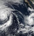
Tropical Storm Darby has been increasing in intensity since yesterday and is expected to become a hurricane. NASA provided a visible look at the structure of the storm and peered through it to determine surface wind speed. On July 12 at 21:45 UTC (5:45 p.m. EDT) the Visible Infrared Imaging Radiometer Suite (VIIRS) instrument aboard NASA-NOAA-DOD's Suomi NPP satellite captured a visible light image of Hurricane Celia and Tropical Storm Darby in the Eastern Pacific Ocean. Celia is located to the northwest of Darby. As of today, July 13, Celia has weakened to a tropical storm.
VIIRS collects visible and infrared imagery and global observations of land, atmosphere, cryosphere and oceans.
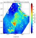
On July 12, RapidScat saw Darby's strongest winds (red) southwest of the center at 27 meters per second (60.4 mph/97.2 kph). Since that time, the National Hurricane Center noticed that Darby had been rapidly intensifying with a 30 knot wind increase over 24 hours. RapidScat is a scatterometer instrument that flies aboard the International Space Station. It measures surface wind speeds and direction over open waters of oceans.
On July 13 at t 5 a.m. EDT (0900 UTC), the center of Tropical Storm Darby was located near latitude 15.3 North, longitude 111.5 West. That's about 540 miles (870 km) west-southwest of Manzanillo, Mexico. Darby was moving toward the west near 12 mph (19 kph) and the National Hurricane Center (NHC) said this general motion is expected for the next couple of days.
Maximum sustained winds have increased to near 70 mph (110 kph) with higher gusts. RapidScat imagery shows tropical-storm-force winds extend outward up to 70 miles (110 km) from the center. The estimated minimum central pressure is 998 millibars.
The NHC expects Darby to become a hurricane later today.
Source: NASA/Goddard Space Flight Center
Articles on the same topic
- GPM measured heavy rain in Tropical Storm EstelleThu, 21 Jul 2016, 17:26:09 UTC
- NASA sees Darby's strongest storms north of centerThu, 21 Jul 2016, 17:25:58 UTC
- Hurricane Darby weakens on approach to Central Pacific OceanWed, 20 Jul 2016, 18:29:58 UTC
- NASA sees a weaker Hurricane Darby in infrared lightWed, 20 Jul 2016, 18:29:47 UTC
- NASA looks at Hurricane Darby's cloud-filled eye, windsWed, 20 Jul 2016, 18:29:38 UTC
- NASA's SMAP Observatory looks at Tropical Storm Estelle's windsWed, 20 Jul 2016, 17:55:17 UTC
- NASA's Aqua satellite sees an almost symmetrical Tropical Storm EstelleTue, 19 Jul 2016, 15:06:41 UTC
- Satellite spots remnants of Ex-Tropical Cyclone CeliaMon, 18 Jul 2016, 18:34:35 UTC
- NASA sees the hint of an eye in Tropical Storm EstelleMon, 18 Jul 2016, 17:04:50 UTC
- NASA satellites see weaker Tropical Storm Celia move into central PacificFri, 15 Jul 2016, 16:54:29 UTC
- Satellite sees Tropical Depression 6E form in Eastern PacificFri, 15 Jul 2016, 16:54:20 UTC
- NASA finds wind shear affecting Tropical Storm CeliaThu, 14 Jul 2016, 18:04:59 UTC
- NASA looks into Tropical Cyclone Celia's winds and rainfall ratesWed, 13 Jul 2016, 21:24:53 UTC
- Satellite movie shows Tropical Cyclone Blas fadingMon, 11 Jul 2016, 17:35:11 UTC
- Satellite sees Hurricane Celia moving away from MexicoMon, 11 Jul 2016, 17:35:02 UTC
- Early daylight satellite image shows depression intensify into Tropical Storm CeliaMon, 11 Jul 2016, 17:34:52 UTC
Other sources
- NASA sees Darby's strongest storms north of centerfrom PhysorgThu, 21 Jul 2016, 18:51:22 UTC
- Hurricane Darby weakens on approach to Central Pacific Oceanfrom PhysorgWed, 20 Jul 2016, 18:21:28 UTC
- SMAP Observatory looks at Tropical Storm Estelle's windsfrom PhysorgWed, 20 Jul 2016, 18:21:25 UTC
- NASA sees a weaker Hurricane Darby in infrared lightfrom PhysorgTue, 19 Jul 2016, 15:31:21 UTC
- NASA's Aqua satellite sees an almost symmetrical Tropical Storm Estellefrom PhysorgTue, 19 Jul 2016, 15:31:19 UTC
- Satellite spots remnants of Ex-Tropical Cyclone Celiafrom PhysorgMon, 18 Jul 2016, 19:01:34 UTC
- NASA looks at Hurricane Darby's cloud-filled eye, windsfrom PhysorgMon, 18 Jul 2016, 17:31:32 UTC
- NASA sees the hint of an eye in Tropical Storm Estellefrom PhysorgMon, 18 Jul 2016, 17:31:27 UTC
- NASA satellites see weaker Tropical Storm Celia move into central Pacificfrom PhysorgFri, 15 Jul 2016, 17:21:07 UTC
- Satellite sees Tropical Depression 6E form in Eastern Pacificfrom PhysorgFri, 15 Jul 2016, 17:21:06 UTC
- NASA finds wind shear affecting Tropical Storm Celiafrom PhysorgThu, 14 Jul 2016, 19:31:13 UTC
- NASA looks into Tropical Cyclone Celia's winds and rainfall ratesfrom PhysorgWed, 13 Jul 2016, 20:48:28 UTC
- NASA looks at a strengthening Tropical Storm Darbyfrom PhysorgWed, 13 Jul 2016, 20:48:26 UTC
- Satellite sees Hurricane Celia moving away from Mexicofrom PhysorgMon, 11 Jul 2016, 17:31:33 UTC
- Satellite movie shows Tropical Cyclone Blas fadingfrom PhysorgMon, 11 Jul 2016, 17:31:30 UTC
- Early daylight satellite image shows depression intensify into Tropical Storm Celiafrom PhysorgFri, 8 Jul 2016, 18:11:04 UTC

