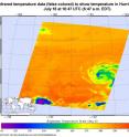
NASA sees a weaker Hurricane Darby in infrared light
Infrared imagery from NASA's Aqua satellite shows that Hurricane Darby is losing its punch. When NASA's Aqua satellite passed over Darby on July 18 at 1047 UTC (6:47 a.m. EDT), the Atmospheric Infrared Sounder known as the AIRS instrument looked at the storm in infrared light. Infrared light provides temperature data, which is important in seeing the height and power of the thunderstorms that make up a tropical cyclone. The colder the cloud tops, the higher they are in the atmosphere, and the stronger the convection or uplift of air (and evaporation, condensation and thunderstorm development).
AIRS data showed that strong convection had been decreasing as cloud top temperatures warmed. That strong convection continued to decrease during the early morning hours on July 19 according to the National Hurricane Center (NHC). However, NHC noted that Darby still has a well-defined and tight circulation.
NHC Forecaster Cangialosi said "Microwave [satellite] data indicates that the low-level center of Darby is located to the south of the eye feature seen in infrared satellite images, which is likely the result of southerly [vertical wind] shear."
At 5 a.m. PDT (0900 UTC) on July 19 the center of Hurricane Darby was located near 19.4 degrees north latitude and 134.4 degrees west longitude. That's about 1,345 miles (2,165 km) east of Hilo, Hawaii. The estimated minimum central pressure is 988 millibars.
Darby is moving toward the west-northwest near 13 mph (20 kph) and this motion is expected to continue today. A turn toward the west is forecast to occur tonight.
Maximum sustained winds remain near 75 mph (120 kph) and weakening is forecast during the next 48 hours. Darby is likely to become a tropical storm later today.
There are no coastal watches or warnings in effect.
Source: NASA/Goddard Space Flight Center
Articles on the same topic
- GPM measured heavy rain in Tropical Storm EstelleThu, 21 Jul 2016, 17:26:09 UTC
- NASA sees Darby's strongest storms north of centerThu, 21 Jul 2016, 17:25:58 UTC
- Hurricane Darby weakens on approach to Central Pacific OceanWed, 20 Jul 2016, 18:29:58 UTC
- NASA looks at Hurricane Darby's cloud-filled eye, windsWed, 20 Jul 2016, 18:29:38 UTC
- NASA's SMAP Observatory looks at Tropical Storm Estelle's windsWed, 20 Jul 2016, 17:55:17 UTC
- NASA's Aqua satellite sees an almost symmetrical Tropical Storm EstelleTue, 19 Jul 2016, 15:06:41 UTC
- Satellite spots remnants of Ex-Tropical Cyclone CeliaMon, 18 Jul 2016, 18:34:35 UTC
- NASA sees the hint of an eye in Tropical Storm EstelleMon, 18 Jul 2016, 17:04:50 UTC
- NASA satellites see weaker Tropical Storm Celia move into central PacificFri, 15 Jul 2016, 16:54:29 UTC
- Satellite sees Tropical Depression 6E form in Eastern PacificFri, 15 Jul 2016, 16:54:20 UTC
- NASA finds wind shear affecting Tropical Storm CeliaThu, 14 Jul 2016, 18:04:59 UTC
- NASA looks into Tropical Cyclone Celia's winds and rainfall ratesWed, 13 Jul 2016, 21:24:53 UTC
- NASA looks at a strengthening Tropical Storm DarbyWed, 13 Jul 2016, 21:24:47 UTC
- Satellite movie shows Tropical Cyclone Blas fadingMon, 11 Jul 2016, 17:35:11 UTC
- Satellite sees Hurricane Celia moving away from MexicoMon, 11 Jul 2016, 17:35:02 UTC
- Early daylight satellite image shows depression intensify into Tropical Storm CeliaMon, 11 Jul 2016, 17:34:52 UTC
Other sources
- NASA sees Darby's strongest storms north of centerfrom PhysorgThu, 21 Jul 2016, 18:51:22 UTC
- Hurricane Darby weakens on approach to Central Pacific Oceanfrom PhysorgWed, 20 Jul 2016, 18:21:28 UTC
- SMAP Observatory looks at Tropical Storm Estelle's windsfrom PhysorgWed, 20 Jul 2016, 18:21:25 UTC
- NASA sees a weaker Hurricane Darby in infrared lightfrom PhysorgTue, 19 Jul 2016, 15:31:21 UTC
- NASA's Aqua satellite sees an almost symmetrical Tropical Storm Estellefrom PhysorgTue, 19 Jul 2016, 15:31:19 UTC
- Satellite spots remnants of Ex-Tropical Cyclone Celiafrom PhysorgMon, 18 Jul 2016, 19:01:34 UTC
- NASA looks at Hurricane Darby's cloud-filled eye, windsfrom PhysorgMon, 18 Jul 2016, 17:31:32 UTC
- NASA sees the hint of an eye in Tropical Storm Estellefrom PhysorgMon, 18 Jul 2016, 17:31:27 UTC
- NASA satellites see weaker Tropical Storm Celia move into central Pacificfrom PhysorgFri, 15 Jul 2016, 17:21:07 UTC
- Satellite sees Tropical Depression 6E form in Eastern Pacificfrom PhysorgFri, 15 Jul 2016, 17:21:06 UTC
- NASA finds wind shear affecting Tropical Storm Celiafrom PhysorgThu, 14 Jul 2016, 19:31:13 UTC
- NASA looks into Tropical Cyclone Celia's winds and rainfall ratesfrom PhysorgWed, 13 Jul 2016, 20:48:28 UTC
- NASA looks at a strengthening Tropical Storm Darbyfrom PhysorgWed, 13 Jul 2016, 20:48:26 UTC
- Satellite sees Hurricane Celia moving away from Mexicofrom PhysorgMon, 11 Jul 2016, 17:31:33 UTC
- Satellite movie shows Tropical Cyclone Blas fadingfrom PhysorgMon, 11 Jul 2016, 17:31:30 UTC
- Early daylight satellite image shows depression intensify into Tropical Storm Celiafrom PhysorgFri, 8 Jul 2016, 18:11:04 UTC
