NASA looks into Tropical Cyclone Celia's winds and rainfall rates
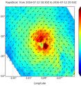
Tropical Cyclone Celia continued to generate heavy rains as it moved through the Eastern Pacific Ocean. NASA's RapidScat analyzed surface wind speeds while the GPM core satellite measured rainfall rates occurring within the storm. RapidScat is a scatterometer instrument that flies aboard the International Space Station. It measures surface wind speeds and direction over open waters of oceans On July 12 RapidScat saw strongest sustained surface winds (red) occurring east of the center of Hurricane Celia. Those winds were in excess of 30 meters per second (67.1 mph/108 kph). Images from RapidScat data are made into images at NASA's Jet Propulsion Laboratory in Pasadena, California where the mission is managed.
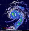
The Global Precipitation Measurement (GPM) core observatory satellite twice flew almost directly above hurricane Celia in the eastern Pacific Ocean on July 12, 2016. The first time was on July 12, 2016 at 0011 UTC (July 11 at 8:11 p.m. EDT) and the second view was on July 12, 2016 at 1326 UTC (9:26 a.m. EDT). With both passes GPM's Microwave Imager (GMI) clearly showed the location of rainfall around hurricane Celia's well defined eye. The hurricane had maintained intensity during this period with sustained maximum wind speeds estimated at 80 knots (92.8 mph). With the first pass GMI measured rain in the southwestern side of Celia's eye wall falling at a rate of close to 33 mm (1.3 inches) per hour. GPM is a joint mission between NASA and the Japanese space agency JAXA.
On July 13 at 5 a.m. EDT (0900 UTC) Celia weakened to a tropical storm. It was centered about 1,410 miles (2,270 km) west of the southern tip of Baja California. Celia was located near latitude 18.3 north and longitude 131.2 west. Celia was moving toward the west-northwest near 12 mph (19 kph) and this general motion is expected to continue for the next couple of days. Maximum sustained winds have decreased to near 70 mph (110 kph) with higher gusts. Additional weakening is forecast during the next 48 hours. The estimated minimum central pressure is 987 millibars.
Celia is moving in the general direction of the Hawaiian Islands but is predicted to weaken to tropical depression intensity in a few days as it moves into the central Pacific.
Source: NASA/Goddard Space Flight Center
Articles on the same topic
- GPM measured heavy rain in Tropical Storm EstelleThu, 21 Jul 2016, 17:26:09 UTC
- NASA sees Darby's strongest storms north of centerThu, 21 Jul 2016, 17:25:58 UTC
- Hurricane Darby weakens on approach to Central Pacific OceanWed, 20 Jul 2016, 18:29:58 UTC
- NASA sees a weaker Hurricane Darby in infrared lightWed, 20 Jul 2016, 18:29:47 UTC
- NASA looks at Hurricane Darby's cloud-filled eye, windsWed, 20 Jul 2016, 18:29:38 UTC
- NASA's SMAP Observatory looks at Tropical Storm Estelle's windsWed, 20 Jul 2016, 17:55:17 UTC
- NASA's Aqua satellite sees an almost symmetrical Tropical Storm EstelleTue, 19 Jul 2016, 15:06:41 UTC
- Satellite spots remnants of Ex-Tropical Cyclone CeliaMon, 18 Jul 2016, 18:34:35 UTC
- NASA sees the hint of an eye in Tropical Storm EstelleMon, 18 Jul 2016, 17:04:50 UTC
- NASA satellites see weaker Tropical Storm Celia move into central PacificFri, 15 Jul 2016, 16:54:29 UTC
- Satellite sees Tropical Depression 6E form in Eastern PacificFri, 15 Jul 2016, 16:54:20 UTC
- NASA finds wind shear affecting Tropical Storm CeliaThu, 14 Jul 2016, 18:04:59 UTC
- NASA looks at a strengthening Tropical Storm DarbyWed, 13 Jul 2016, 21:24:47 UTC
- Satellite movie shows Tropical Cyclone Blas fadingMon, 11 Jul 2016, 17:35:11 UTC
- Satellite sees Hurricane Celia moving away from MexicoMon, 11 Jul 2016, 17:35:02 UTC
- Early daylight satellite image shows depression intensify into Tropical Storm CeliaMon, 11 Jul 2016, 17:34:52 UTC
Other sources
- NASA sees Darby's strongest storms north of centerfrom PhysorgThu, 21 Jul 2016, 18:51:22 UTC
- Hurricane Darby weakens on approach to Central Pacific Oceanfrom PhysorgWed, 20 Jul 2016, 18:21:28 UTC
- SMAP Observatory looks at Tropical Storm Estelle's windsfrom PhysorgWed, 20 Jul 2016, 18:21:25 UTC
- NASA sees a weaker Hurricane Darby in infrared lightfrom PhysorgTue, 19 Jul 2016, 15:31:21 UTC
- NASA's Aqua satellite sees an almost symmetrical Tropical Storm Estellefrom PhysorgTue, 19 Jul 2016, 15:31:19 UTC
- Satellite spots remnants of Ex-Tropical Cyclone Celiafrom PhysorgMon, 18 Jul 2016, 19:01:34 UTC
- NASA looks at Hurricane Darby's cloud-filled eye, windsfrom PhysorgMon, 18 Jul 2016, 17:31:32 UTC
- NASA sees the hint of an eye in Tropical Storm Estellefrom PhysorgMon, 18 Jul 2016, 17:31:27 UTC
- NASA satellites see weaker Tropical Storm Celia move into central Pacificfrom PhysorgFri, 15 Jul 2016, 17:21:07 UTC
- Satellite sees Tropical Depression 6E form in Eastern Pacificfrom PhysorgFri, 15 Jul 2016, 17:21:06 UTC
- NASA finds wind shear affecting Tropical Storm Celiafrom PhysorgThu, 14 Jul 2016, 19:31:13 UTC
- NASA looks into Tropical Cyclone Celia's winds and rainfall ratesfrom PhysorgWed, 13 Jul 2016, 20:48:28 UTC
- NASA looks at a strengthening Tropical Storm Darbyfrom PhysorgWed, 13 Jul 2016, 20:48:26 UTC
- Satellite sees Hurricane Celia moving away from Mexicofrom PhysorgMon, 11 Jul 2016, 17:31:33 UTC
- Satellite movie shows Tropical Cyclone Blas fadingfrom PhysorgMon, 11 Jul 2016, 17:31:30 UTC
- Early daylight satellite image shows depression intensify into Tropical Storm Celiafrom PhysorgFri, 8 Jul 2016, 18:11:04 UTC

