Former Hurricane Pali peters out near Equator
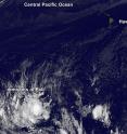
West satellite has shown that former Hurricane Pali has petered out near the Equator. The NASA/NOAA GOES Project at NASA's Goddard Space Flight Center in Greenbelt, Maryland created an image of the remnant clouds of former Hurricane Pali from NOAA's GOES-West satellite data. The image was taken on Jan. 15 at 1200 UTC (7 a.m. EST) and showed the elongated former tropical cyclone just north of the Equator.
At 10 a.m. EST (1500 UTC) Pali's remnants were dissipating near the Equator far southwest of Hawaii. Maximum sustained winds were near 30 mph (45 kph) and weakening. Vertical wind shear of about 30 knots (34.5 mph/55.5 kph) continued to blow over the area which helped elongate the former tropical depression. NOAA's Central Pacific Hurricane Center noted "microwave satellite data showed the circulation associated with Pali had become highly disrupted and elongated...and it is no longer possible to definitively locate a closed center."
At that time Pali's remnants were about 1,700 miles (2,735 km) southwest of Honolulu, Hawaii and about 1,065 miles (1,715 km) south-southwest of Johnston Island, near latitude 1.7 north and longitude 173.2 west. Pali's remnants were moving toward the southwest near 3 mph (6 kph).
The remnants of Pali are expected to continue tracking slowly southwest for the next couple of days.
Source: NASA/Goddard Space Flight Center
Articles on the same topic
- NASA sees Tropical Depression Pali headed toward EquatorThu, 14 Jan 2016, 20:15:08 UTC
- NASA analyzes Hurricane Pali's rainfall ratesWed, 13 Jan 2016, 18:45:43 UTC
- NASA's Terra satellite spots record-breaking Hurricane PaliTue, 12 Jan 2016, 16:55:47 UTC
- NASA eyeing an interesting weather system in northern AtlanticMon, 11 Jan 2016, 20:27:25 UTC
- Unusual Tropical Storm Pali still thriving far from HawaiiMon, 11 Jan 2016, 18:52:32 UTC
- NASA investigates Tropical Storm Pali's temperatures, windsFri, 8 Jan 2016, 22:24:12 UTC
- NASA sees out-of-season Central Pacific tropical depression formFri, 8 Jan 2016, 22:23:54 UTC
Other sources
- Former Hurricane Pali peters out near Equatorfrom PhysorgFri, 15 Jan 2016, 21:24:29 UTC
- NASA sees Tropical Depression Pali headed toward Equatorfrom PhysorgThu, 14 Jan 2016, 20:45:39 UTC
- NASA analyzes Hurricane Pali's rainfall ratesfrom PhysorgWed, 13 Jan 2016, 18:32:13 UTC
- A Hurricane? In January? You Can Thank El Niñofrom Live ScienceWed, 13 Jan 2016, 3:04:04 UTC
- NASA's Terra satellite spots record-breaking Hurricane Palifrom Science DailyTue, 12 Jan 2016, 22:34:03 UTC
- NASA satellite photographs record-breaking Hurricane Palifrom UPITue, 12 Jan 2016, 20:12:31 UTC
- Terra satellite spots record-breaking Hurricane Palifrom PhysorgTue, 12 Jan 2016, 17:41:00 UTC
- NASA eyeing an interesting weather system in northern Atlanticfrom PhysorgMon, 11 Jan 2016, 20:54:26 UTC
- Unusual Tropical Storm Pali still thriving far from Hawaiifrom PhysorgMon, 11 Jan 2016, 19:20:56 UTC
- Unusual January tropical storm forms southwest of Hawaiifrom PhysorgFri, 8 Jan 2016, 23:23:08 UTC
- Unusual January tropical storm forms southwest of Hawaiifrom AP ScienceFri, 8 Jan 2016, 22:21:02 UTC
- NASA investigates Tropical Storm Pali's temperatures, windsfrom PhysorgFri, 8 Jan 2016, 19:44:47 UTC
- NASA sees out-of-season Central Pacific tropical depression formfrom PhysorgFri, 8 Jan 2016, 0:04:59 UTC
