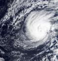
NASA's Terra satellite spots record-breaking Hurricane Pali
Shortly after NASA's Terra satellite passed over Tropical Storm Pali it strengthened into a record-breaking hurricane. On Jan. 11 at 22:30 UTC (5:30 p.m. EST) the MODIS instrument aboard NASA's Terra satellite captured a visible image of strengthening Tropical Storm Pali in the Central Pacific Ocean. On Jan. 11 at 10 p.m. EST (5 p.m. HST/Jan 12 at 0300 UTC) Pali became the earliest hurricane on record in the central Pacific basin far to the southwest of Hawaii. In the MODIS image, Pali's eye was visible surrounded by a strong circle of thunderstorms and a thick band of thunderstorms spiraled into the low level center from the western quadrant.
NOAA's Central Pacific Hurricane Center forecaster Wroe noted "after exhibiting a rather well defined eye through the evening...a recent burst of deep convection around the center of Hurricane Pali has caused the eye to become cloud filled...likely due to southwesterly vertical wind shear of around 15 knots."
On Jan. 12 at 10 a.m. EST (5 a.m. HST/1500 UTC) the center of Hurricane Pali was located near latitude 6.8 north and longitude 171.4 west. That's about 695 miles (1,120 km) south of Johnston Island and 1,345 miles (2,170 km) southwest of Honolulu, Hawaii. Maximum sustained winds are near 90 mph (150 kph). Slow weakening is expected through Thursday morning, Jan. 14. The estimated minimum central pressure is 979 millibars. Pali was moving toward the south near 7 mph and is expected to gradually turn to the southwest.
CPHC said that although Pali will remain over warm sea surface temperatures of 28 to 29 Celsius (82.4 to 84.2 Fahrenheit) along the forecast track...ships indicates a modest Increase in wind shear that could produce some weakening during the next couple of days as it moves toward the equator. For updated forecasts, visit: http://www.prh.noaa.gov/cphc.
Source: NASA/Goddard Space Flight Center
Articles on the same topic
- Former Hurricane Pali peters out near EquatorFri, 15 Jan 2016, 19:42:01 UTC
- NASA sees Tropical Depression Pali headed toward EquatorThu, 14 Jan 2016, 20:15:08 UTC
- NASA analyzes Hurricane Pali's rainfall ratesWed, 13 Jan 2016, 18:45:43 UTC
- NASA eyeing an interesting weather system in northern AtlanticMon, 11 Jan 2016, 20:27:25 UTC
- Unusual Tropical Storm Pali still thriving far from HawaiiMon, 11 Jan 2016, 18:52:32 UTC
- NASA investigates Tropical Storm Pali's temperatures, windsFri, 8 Jan 2016, 22:24:12 UTC
- NASA sees out-of-season Central Pacific tropical depression formFri, 8 Jan 2016, 22:23:54 UTC
Other sources
- Former Hurricane Pali peters out near Equatorfrom PhysorgFri, 15 Jan 2016, 21:24:29 UTC
- NASA sees Tropical Depression Pali headed toward Equatorfrom PhysorgThu, 14 Jan 2016, 20:45:39 UTC
- NASA analyzes Hurricane Pali's rainfall ratesfrom PhysorgWed, 13 Jan 2016, 18:32:13 UTC
- A Hurricane? In January? You Can Thank El Niñofrom Live ScienceWed, 13 Jan 2016, 3:04:04 UTC
- NASA's Terra satellite spots record-breaking Hurricane Palifrom Science DailyTue, 12 Jan 2016, 22:34:03 UTC
- NASA satellite photographs record-breaking Hurricane Palifrom UPITue, 12 Jan 2016, 20:12:31 UTC
- Terra satellite spots record-breaking Hurricane Palifrom PhysorgTue, 12 Jan 2016, 17:41:00 UTC
- NASA eyeing an interesting weather system in northern Atlanticfrom PhysorgMon, 11 Jan 2016, 20:54:26 UTC
- Unusual Tropical Storm Pali still thriving far from Hawaiifrom PhysorgMon, 11 Jan 2016, 19:20:56 UTC
- Unusual January tropical storm forms southwest of Hawaiifrom PhysorgFri, 8 Jan 2016, 23:23:08 UTC
- Unusual January tropical storm forms southwest of Hawaiifrom AP ScienceFri, 8 Jan 2016, 22:21:02 UTC
- NASA investigates Tropical Storm Pali's temperatures, windsfrom PhysorgFri, 8 Jan 2016, 19:44:47 UTC
- NASA sees out-of-season Central Pacific tropical depression formfrom PhysorgFri, 8 Jan 2016, 0:04:59 UTC
