TRMM satellite makes direct pass over Super Typhoon Maysak
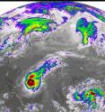
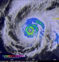
The Tropical Rainfall Measuring Mission satellite delivered a remarkable image of Super Typhoon Maysak on March 31. TRMM obtained an image straight over the top of a super typhoon with a double eye-wall, Super Typhoon Maysak, as it roared through the warm waters of the West Pacific south of Guam. This image with the TRMM Precipitation Radar or PR was taken at 14:15 UTC (10:15 a.m. EDT) on March 31, 2015 and shows the rain intensities within the very heart of Super Typhoon Maysak as it undergoes an eye wall replacement cycle. Mature, intense tropical cyclones can and often do undergo what is known as an eyewall replacement cycle wherein a new eye wall or ring of convection within the outer rain bands forms further out from the storm's center, outside the radius of the original eye wall, and begins to choke off the original eye wall, starving it of moisture and momentum. Eventually, if the cycle is completed, the original eye wall dissipates and this new outer eye wall can contract and replace the old eye wall. The storm's intensity can fluctuate over this period, initially weakening as the inner eye wall dies before again strengthening as the outer eye wall contracts. Eye wall replacement cycles are hard to forecast.
Here TRMM provided a look at a classic eye wall replacement cycle in progress. At the very center is the eye of Super Typhoon Maysak, which is devoid of rain where air is descending. Immediately surrounding the eye is the original inner eye wall where air is rising in convective updrafts and releasing heat through condensation. The vast amounts of heat being released into the storm as a result is known as latent heating and is what drives the storm's circulation. The inner eye wall is identified by the nearly complete ring of very intense rainfall with rates on the order of 100 mm/hr or more (~4 inches/hr, shown by the white areas inside the light purple) in the southwestern semicircle. Outside of the inner eye wall is a very distinct ring of very weak rain (~5 mm/hr or less, shown in blue), known as the moat. The moat marks the area between the inner and outer eye walls where air that has already risen through the updrafts in the eye walls is now subsiding, suppressing rain. Next, outside of the moat is the new outer eye wall, shown by the nearly perfect concentric ring of moderate (shown in green) to heavy (shown in red) rain rates. Additional bands of light to moderate rain (blue and green areas, respectively) wrap around the northeast quadrant Maysak.
Another key aspect of Maysak's features as revealed by TRMM is their near perfect symmetry around the storm's center. This is a clear sign of the storm's intensity. The more intense the circulation, the more uniformly rain features are wrapped around the center. Indeed, at the time this image was taken by TRMM, Maysak's maximum sustained winds were estimated to be 140 knots (~161 mph) by the Joint Typhoon Warning Center, making it a Category 5 super typhoon (equivalent to a Category 5 hurricane on the U.S. Saffir-Simpson scale).
Maysak is the first super typhoon of the season in the Northwest Pacific Basin. The storm is forecast to weaken before approaching the northern Philippines in the next couple of days. TRMM is a joint mission between NASA and the Japanese space agency JAXA.
Source: NASA/Goddard Space Flight Center
Other sources
- NASA sees Typhoon Maysak weakeningfrom PhysorgFri, 3 Apr 2015, 19:00:19 UTC
- TRMM satellite makes direct pass over Super Typhoon Maysakfrom Science DailyThu, 2 Apr 2015, 22:00:10 UTC
- TRMM satellite makes direct pass over Super Typhoon Maysakfrom PhysorgThu, 2 Apr 2015, 21:00:09 UTC
- NASA's ISS-RapidScat: Typhoon Maysak's strongest winds tightly woundfrom PhysorgThu, 2 Apr 2015, 21:00:08 UTC
- International Space Station captures images of super-typhoon Maysak – videofrom The Guardian - ScienceThu, 2 Apr 2015, 9:00:15 UTC
- From Space, Typhoon Maysak's Eye Looks Like a Black Hole (Photo)from Space.comThu, 2 Apr 2015, 4:30:29 UTC
- Typhoon Maysak seen from International Space Stationfrom UPIWed, 1 Apr 2015, 22:00:05 UTC
- From Space, Typhoon Maysak's Eye Looks Like a Black Hole (Photo)from Live ScienceWed, 1 Apr 2015, 21:30:10 UTC
- NASA covers Super Typhoon Maysak's rainfall, winds, clouds, eyefrom PhysorgWed, 1 Apr 2015, 18:00:45 UTC
- Super Typhoon Awes Astronautfrom MSNBC: ScienceWed, 1 Apr 2015, 17:30:15 UTC
- Typhoon Maysak seen from spacefrom CBSNews - ScienceWed, 1 Apr 2015, 15:20:06 UTC
- NASA sees Maysak become a super typhoonfrom PhysorgTue, 31 Mar 2015, 16:30:40 UTC
- Typhoon Maysak heads for Philippinesfrom UPITue, 31 Mar 2015, 15:00:35 UTC
- NASA's ISS-RapidScat sees Typhoon Maysak's stronger winds become more uniformfrom PhysorgMon, 30 Mar 2015, 20:30:43 UTC

