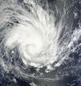
NASA sees large Tropical Cyclone Yasi headed toward Queensland, Australia
Tropical Storm Anthony made landfall in Queensland, Australia this past weekend, and now the residents are watching a larger, more powerful cyclone headed their way. NASA's Terra satellite captured a visible image of the large Tropical Cyclone Yasi late yesterday as it makes its way west through the Coral Sea toward Queensland. The Moderate Resolution Imaging Spectroradiometer (MODIS) instrument that flies aboard NASA's Terra satellite captured an image of Cyclone Yasi on Jan. 30 at 23:20 UTC (6:20 p.m. EST/09:20 a.m., Monday, January 31 in Australia/Brisbane local time). Although the image did not reveal a visible eye, the storm appears to be well-formed and also appears to be strengthening.
Warnings and watches are already in effect throughout the Coral Sea. The Solomon Islands currently have a Tropical Cyclone warning for the provinces of Temotu, Rennell& Bellona, Makira and Guadalcanal. The Australian Bureau of Meteorology has already posted a Tropical Cyclone Watch from Cooktown to Yeppoon and inland to between Georgetown and Moranbah in Queensland, Australia. The Australian Bureau of Meteorology expects damaging winds to develop in coastal and island communities between Cooktown and Yeppoon Wednesday morning, and inland areas on Wednesday afternoon. Updates from the Australian Bureau of Meteorology can be monitored at the Bureau's website at www.bom.gov.au.
On January 31 at 1500 UTC (10 a.m. EST/ 1:00 a.m. Tuesday February 1, 2011 in Australia/Brisbane local time), Tropical Cyclone Yasi had maximum sustained winds near 90 knots (103 mph/166 kmh). Yasi is a Category Two Cyclone on the Saffir-Simpson Scale.
It was centered about 875 miles E of Cairns, Australia, near 13.4 South latitude and 160.4 East longitude. It was moving west near 19 knots (22 mph/35 kmh). Cyclone-force winds extend out to 30 miles (48 km) from the center.
Animated infrared satellite imagery, such as that from the Atmospheric Infrared Sounder (AIRS) that flies on NASA's Aqua satellite, showed deep convective (thunderstorm) bands wrapping tighter into the low level circulation center. Wrapping bands of thunderstorms indicate strengthening.
Yasi is forecast to move west then southwestward into an area of low vertical wind shear (strong wind shear can weaken a storm). Forecasters at the Joint Typhoon Warning Center (JTWC) expect Yasi to continue strengthening over the next 36 hours. JTWC forecasts a landfall just south of Cairns as a large 100-plus knot (115 mph/185 kmh)n system by Wednesday. Residents along the Queensland coast should now be making preparations now for the storm's arrival.
Source: NASA/Goddard Space Flight Center
Articles on the same topic
- NASA measuring Tropical Storm Yasi's inland rainfall from spaceThu, 3 Feb 2011, 21:36:18 UTC
- University of Leicester releases stunning satellite imagery of cyclone Yasi from spaceThu, 3 Feb 2011, 16:34:16 UTC
- NASA Aqua Satellite sees powerful Cyclone Yasi make landfall in Queensland, AustraliaWed, 2 Feb 2011, 22:03:02 UTC
- NASA satellites reveal heavy rains in dangerous Cyclone Yasi on its Australian approachTue, 1 Feb 2011, 20:34:36 UTC
Other sources
- NASA measuring Tropical Storm Yasi's inland rainfall from spacefrom PhysorgThu, 3 Feb 2011, 22:01:06 UTC
- NASA measuring Tropical Storm Yasi’s inland rainfall from spacefrom Science BlogThu, 3 Feb 2011, 22:00:37 UTC
- Scientists release stunning satellite imagery of cyclone Yasi from space (w/ Video)from PhysorgThu, 3 Feb 2011, 17:09:17 UTC
- University of Leicester releases stunning satellite imagery of cyclone Yasi from spacefrom Science BlogThu, 3 Feb 2011, 17:05:01 UTC
- NASA Aqua Satellite sees powerful Cyclone Yasi make landfall in Queensland, Australiafrom Science DailyThu, 3 Feb 2011, 3:30:41 UTC
- NASA Aqua Satellite sees powerful Cyclone Yasi make landfall in Queensland, Australiafrom PhysorgWed, 2 Feb 2011, 23:00:36 UTC
- NASA Aqua Satellite sees powerful Cyclone Yasi make landfall in Queensland, Australiafrom Science BlogWed, 2 Feb 2011, 23:00:28 UTC
- Cyclone Yasi expected to make landfall at midnight tonightfrom The Guardian - ScienceWed, 2 Feb 2011, 13:31:47 UTC
- Cyclone Yasi closes in on Australiafrom CBC: Technology & ScienceWed, 2 Feb 2011, 13:31:17 UTC
- Queenslanders bracing for cyclonefrom BBC News: Science & NatureWed, 2 Feb 2011, 10:32:27 UTC
- NASA satellite tracks menacing Australian cyclonefrom Science DailyWed, 2 Feb 2011, 6:30:49 UTC
- Monster cyclone Yasi eyes Australia in NASA imagefrom Science DailyWed, 2 Feb 2011, 6:30:31 UTC
- Monster Cyclone Yasi Eyes Australia in NASA Imagefrom NASA Jet Propulsion LaboratoryWed, 2 Feb 2011, 1:50:13 UTC
- NASA satellites reveal heavy rains in dangerous Cyclone Yasi on its Australian approachfrom Science BlogWed, 2 Feb 2011, 0:20:45 UTC
- NASA satellites reveal heavy rains in dangerous Cyclone Yasi on its Australian approachfrom PhysorgTue, 1 Feb 2011, 21:30:24 UTC
- NASA Satellite Tracks Menacing Australian Cyclonefrom NASA Jet Propulsion LaboratoryTue, 1 Feb 2011, 1:20:26 UTC
- NASA sees large Tropical Cyclone Yasi headed toward Queensland, Australiafrom Science BlogMon, 31 Jan 2011, 20:33:43 UTC
- NASA sees large tropical cyclone Yasi headed toward Queensland, Australiafrom PhysorgMon, 31 Jan 2011, 19:20:10 UTC
