NASA's Aqua and Terra satellites view Tropical Storms Blas and Celia
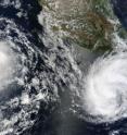
Tropical cyclones Blas and Celia are both spinning in the Eastern Pacific Ocean, and two NASA satellites captured them in visible and infrared imagery. On June 19 at 17:30 UTC (1:30 p.m. EDT) the Moderate Resolution Imaging Spectroradiometer (MODIS) instrument on NASA's Terra satellite captured a visible image of Blas when it was still a tropical storm and the newly developed Tropical Storm Celia. Celia formed on June 19 and by 1500 UTC (11 a.m. EDT) had strengthened into a tropical storm. The storm was "born" about 355 miles south-southeast of Acapulco, Mexico, near 12.5 North and 97.1 West.
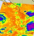
The following day, June 20 at 08:47 UTC (4:47 a.m. EDT), the Atmospheric Infrared Sounder (AIRS) instrument on NASA's Aqua satellite captured an infrared image of both Tropical Storm Blas and Celia. The infrared image measured the temperature of each cyclone's clouds, and the warm ocean waters that surround them.
The AIRS infrared image revealed that the convection in Blas was waning and the areas of strong convection (rapidly rising air that condenses and forms the thunderstorms that make up a tropical cyclone) were less than they were the day before.
Convection in Celia had increased and AIRS imagery revealed a larger area of strong convection than on June 19. The imagery showed very cold thunderstorm cloud tops (as cold as or colder than -63 degrees Fahrenheit). That increased area of high, cold thunderstorm cloud tops indicated that Celia was strengthening.
By the morning of June 21 (EDT), Blas had weakened further and is now a tropical depression with maximum sustained winds near 35 mph. Blas is located about 575 miles southwest of Cabo San Lucas, Mexico, near 18.0 North and 117.1 West. Blas continues to move west around 12 mph (11 knots) further into open waters. Blas is forecast to dissipate sometime on June 22.
Meanwhile, Celia has continued to strengthen and is now a hurricane with maximum sustained winds near 80 mph (70 knots). Tropical-storm force winds extend out to 70 miles from the center, making the storm about 140 miles in diameter. Hurricane-force winds only extend out to 15 miles from Celia's center. Celia is located about 380 miles south-southwest of Acapulco, Mexico near 11.8 North and 102.1 West. She's moving west at 9 mph (8 knots). Celia is no threat to land and will continue to move west, then west-northwest, farther away from land.
Source: NASA/Goddard Space Flight Center
Articles on the same topic
- NASA infrared imagery hinted Darby would become a hurricaneThu, 24 Jun 2010, 21:22:40 UTC
- NASA's infrared satellite imagery sees Tropical Storm Darby form quicklyWed, 23 Jun 2010, 19:03:46 UTC
- NASA's TRMM Satellite sees Tropical Depression 2-E dissipatingFri, 18 Jun 2010, 20:03:48 UTC
- Tropical Storm Blas bearing bouts of strong convection in NASA imageryFri, 18 Jun 2010, 20:03:47 UTC
- Tropical Depression 2-E struggling, while Tropical Storm Blas is bornThu, 17 Jun 2010, 20:13:58 UTC
- Tropical Depression 2-E forms in the Eastern Pacific, number 3 may followWed, 16 Jun 2010, 21:04:11 UTC
Other sources
- NASA infrared imagery hinted Darby would become a hurricanefrom Science BlogThu, 24 Jun 2010, 22:01:04 UTC
- NASA infrared imagery hinted Darby would become a hurricanefrom PhysorgThu, 24 Jun 2010, 21:30:41 UTC
- NASA’s infrared satellite imagery sees Tropical Storm Darby form quicklyfrom Science BlogWed, 23 Jun 2010, 21:02:36 UTC
- Aqua infrared satellite imagery sees Tropical Storm Darby form quicklyfrom PhysorgWed, 23 Jun 2010, 20:30:27 UTC
- NASA’s Aqua and Terra satellites view Tropical Storms Blas and Celiafrom Science BlogMon, 21 Jun 2010, 19:30:20 UTC
- NASA's Aqua and Terra satellites view Tropical Storms Blas and Celiafrom PhysorgMon, 21 Jun 2010, 19:01:36 UTC
- NASA's TRMM Satellite sees Tropical Depression 2-E dissipatingfrom PhysorgFri, 18 Jun 2010, 21:30:58 UTC
- Tropical Storm Blas bearing bouts of strong convection in NASA imageryfrom PhysorgFri, 18 Jun 2010, 21:30:51 UTC
- Tropical Storm Blas bearing bouts of strong convection in NASA imageryfrom Science BlogFri, 18 Jun 2010, 20:30:40 UTC
- NASA’s TRMM Satellite sees Tropical Depression 2-E dissipatingfrom Science BlogFri, 18 Jun 2010, 20:30:39 UTC
- Tropical Depression 2-E struggling, while Tropical Storm Blas is bornfrom Science BlogThu, 17 Jun 2010, 20:50:18 UTC
- Tropical Depression 2-E struggling, while Tropical Storm Blas is bornfrom PhysorgThu, 17 Jun 2010, 20:20:19 UTC
- Tropical Depression 2-E forms in the Eastern Pacific, number 3 may followfrom Science BlogWed, 16 Jun 2010, 22:31:46 UTC
- Tropical Depression 2-E forms in the Eastern Pacific, number 3 may followfrom PhysorgWed, 16 Jun 2010, 21:00:56 UTC

