NASA's TRMM Satellite sees Tropical Depression 2-E dissipating
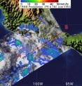
The National Hurricane Center issued the final advisory on the Eastern Pacific Ocean's second tropical depression (2-E) on June 17 at 11 a.m. EDT. NASA satellite imagery from mid-afternoon that day revealed the depression's rains were waning, and the heaviest rainfall was over open ocean. As of June 18 Tropical Depression 2-E had dissipated off the coast. The Tropical Rainfall Measuring Mission satellite known as TRMM measures rainfall from space. TRMM is a joint mission between NASA and the Japanese Space Agency and is a critical tool for forecasters of tropical cyclones because it can tell the rate of rainfall in a storm, acting as a "rain gauge from space." TRMM's satellite image of Tropical Depression 2-E (TD2-E) on June 17 at 19:59 UTC (3:59 p.m. EDT) showed that moderate rainfall was occurring over the ocean, off the western Mexican coast. TRMM showed that light rain was falling over Oaxaca at that time.
On June 18 at 9 a.m. EDT, weather stations in Oxaca were reporting overcast conditions (at 10,000 feet), light drizzle, and a light wind of 2 mph from the northwest. Acapulco, located to the north-northwest of Oxaca is just reporting overcast skies with calm winds.
The last official position of Tropical Depression 2-E at 11 a.m. EDT was 35 miles south of Punto Maldonado, Mexico, near 15.8 North and 98.6 West. At that time, TD2-E still had maximum sustained winds near 30 mph, and a minimum central pressure of 1008 millibars.
The government of Mexico discontinued all tropical storm watches and warnings by mid-day on June 17.
Source: NASA/Goddard Space Flight Center
Articles on the same topic
- NASA infrared imagery hinted Darby would become a hurricaneThu, 24 Jun 2010, 21:22:40 UTC
- NASA's infrared satellite imagery sees Tropical Storm Darby form quicklyWed, 23 Jun 2010, 19:03:46 UTC
- NASA's Aqua and Terra satellites view Tropical Storms Blas and CeliaMon, 21 Jun 2010, 19:08:02 UTC
- Tropical Storm Blas bearing bouts of strong convection in NASA imageryFri, 18 Jun 2010, 20:03:47 UTC
- Tropical Depression 2-E struggling, while Tropical Storm Blas is bornThu, 17 Jun 2010, 20:13:58 UTC
- Tropical Depression 2-E forms in the Eastern Pacific, number 3 may followWed, 16 Jun 2010, 21:04:11 UTC
Other sources
- NASA infrared imagery hinted Darby would become a hurricanefrom Science BlogThu, 24 Jun 2010, 22:01:04 UTC
- NASA infrared imagery hinted Darby would become a hurricanefrom PhysorgThu, 24 Jun 2010, 21:30:41 UTC
- NASA’s infrared satellite imagery sees Tropical Storm Darby form quicklyfrom Science BlogWed, 23 Jun 2010, 21:02:36 UTC
- Aqua infrared satellite imagery sees Tropical Storm Darby form quicklyfrom PhysorgWed, 23 Jun 2010, 20:30:27 UTC
- NASA’s Aqua and Terra satellites view Tropical Storms Blas and Celiafrom Science BlogMon, 21 Jun 2010, 19:30:20 UTC
- NASA's Aqua and Terra satellites view Tropical Storms Blas and Celiafrom PhysorgMon, 21 Jun 2010, 19:01:36 UTC
- NASA's TRMM Satellite sees Tropical Depression 2-E dissipatingfrom PhysorgFri, 18 Jun 2010, 21:30:58 UTC
- Tropical Storm Blas bearing bouts of strong convection in NASA imageryfrom PhysorgFri, 18 Jun 2010, 21:30:51 UTC
- Tropical Storm Blas bearing bouts of strong convection in NASA imageryfrom Science BlogFri, 18 Jun 2010, 20:30:40 UTC
- NASA’s TRMM Satellite sees Tropical Depression 2-E dissipatingfrom Science BlogFri, 18 Jun 2010, 20:30:39 UTC
- Tropical Depression 2-E struggling, while Tropical Storm Blas is bornfrom Science BlogThu, 17 Jun 2010, 20:50:18 UTC
- Tropical Depression 2-E struggling, while Tropical Storm Blas is bornfrom PhysorgThu, 17 Jun 2010, 20:20:19 UTC
- Tropical Depression 2-E forms in the Eastern Pacific, number 3 may followfrom Science BlogWed, 16 Jun 2010, 22:31:46 UTC
- Tropical Depression 2-E forms in the Eastern Pacific, number 3 may followfrom PhysorgWed, 16 Jun 2010, 21:00:56 UTC
