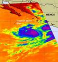
Tropical Storm Blas bearing bouts of strong convection in NASA imagery
Tropical Storm Blas is on a west-northwesterly track in the open waters of the Eastern Pacific Ocean, and a NASA satellite flying overhead noticed some strong areas of convection in the storm. NASA's Aqua satellite flew over Tropical Storm Blas on June 17 at 20:41 UTC (4:41 p.m. EDT) and captured an infrared image of the storm from the Atmospheric Infrared Sounder (AIRS) instrument. The AIRS image showed two areas of very high, frigid clouds (as cold as or colder than -63 Fahrenheit) in the northeastern and eastern areas of the storm. That strong convection shifted overnight to the southeastern region of the storm.
At 09:00 UTC (5 a.m. EDT), Blas was located about 270 miles (440 kilometers) southwest of Manzanillo, Mexico near 15.8 North and 106.7 West. It was moving west-northwest near 5 mph (4 knots). Blas' maximum sustained winds are near 40 mph (35 knots), and its estimated minimum central pressure is near 1000 millibars. Tropical storm force winds extend outward up to 70 miles (110 km) mainly to the southeast of the center.
The National Hurricane Center noted in their discussion on the morning of June 18, "Numerous [areas of] strong convection appears within 90 nautical miles of center over the southern semicircle. Scattered moderate/isolated strong convection is within 30 nm of a line from 16 North and 107 West to 17 North and 110 West."
During the overnight hours from June 17 to June 18, Blas convection (rapidly rising air that condenses and forms clouds and thunderstorms) has weakened. By the early morning hours of June 18, the convection in the storm had deepened quickly.
Over the weekend of June 19 and 20, Blas is forecast to change very little in strength while continuing to track to the west-northwest in open waters of the Eastern Pacific Ocean.
Source: NASA/Goddard Space Flight Center
Articles on the same topic
- NASA infrared imagery hinted Darby would become a hurricaneThu, 24 Jun 2010, 21:22:40 UTC
- NASA's infrared satellite imagery sees Tropical Storm Darby form quicklyWed, 23 Jun 2010, 19:03:46 UTC
- NASA's Aqua and Terra satellites view Tropical Storms Blas and CeliaMon, 21 Jun 2010, 19:08:02 UTC
- NASA's TRMM Satellite sees Tropical Depression 2-E dissipatingFri, 18 Jun 2010, 20:03:48 UTC
- Tropical Depression 2-E struggling, while Tropical Storm Blas is bornThu, 17 Jun 2010, 20:13:58 UTC
- Tropical Depression 2-E forms in the Eastern Pacific, number 3 may followWed, 16 Jun 2010, 21:04:11 UTC
