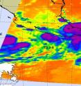
Tropical Depression 2-E struggling, while Tropical Storm Blas is born
NASA infrared satellite imagery captured two tropical depressions in the Eastern Pacific Ocean today, as one struggles to survive and the other powered up into Tropical Storm Blas. On June 17 at 08:11 UTC (4:11 a.m. EDT/1:11 PDT) the Atmospheric Infrared Sounder (AIRS) instrument that flies aboard NASA's Aqua satellite captured an infrared image of Tropical Depression 2-E (TD2-E) hugging the coast of western Mexico and the western half of Tropical Storm Blas which is farther west and in open waters. Both have high, strong thunderstorms in their center. The AIRS image indicates strong convection, with cloud top temperatures as cold or colder than -63 Fahrenheit.
Tropical Depression 2-E in the Eastern Pacific is close to land and although it is having difficultly strengthening it is still bringing a lot of rain to the western Mexican coast to the states of Oxaca and southern Guerrero. At 5 a.m. PDT (8 a.m. EDT) TD2-E still had maximum sustained winds near 30 mph, as it did 24 hours before. It was located near 15.6 North and 98.0 West, about 60 miles (100 km) west-southwest of Puerto Escondido, Mexico, or 65 miles (105 km) southeast of Punto Maldonado, Mexico. TD2-E is moving at 9 mph (15 km/hr) toward the west-northwest, and has a minimum central pressure of 1008 millibars.
Heavy rainfall is the main threat from this system. A tropical storm warning is in effect for Salina Cruz to Acapulco, Mexico and a tropical storm watch in in effect for areas west of Acapulco to Zihuatanejo. TD2-E is expected to continue moving north-northwest along the coast for the next day or two, continuing its rainy assault over land.
TD2-E is expected to produce total rain accumulations of 4 to 8 inches along the coast of the state of Oaxaca and southern Guerrero, with possible isolated maximum amounts of 12 inches. These rains could produce life-threatening flash floods and mudslides.
At 11 a.m. EDT (8 a.m. PDT) on June 17, the third tropical depression of the Eastern Pacific Hurricane Season was born. By 11:40 a.m. EDT (8:40 a.m. PDT) Tropical Depression 3-E (TD3-E) had strengthened into Tropical Storm Blas with maximum sustained winds near 40 mph and is expected to strengthen more over the next 48 hours. It is currently located about 265 miles (425 km) south-southwest of Manzanillo, Mexico, near 15.3 North latitude and 105.3 West longitude. It is moving northeast near 2 mph (4 km/hr) and is expected to turn to the west-northwest. Estimated minimum central pressure is 1006 millibars. There are no coastal warnings in effect for this tropical storm.
Source: NASA/Goddard Space Flight Center
Articles on the same topic
- NASA infrared imagery hinted Darby would become a hurricaneThu, 24 Jun 2010, 21:22:40 UTC
- NASA's infrared satellite imagery sees Tropical Storm Darby form quicklyWed, 23 Jun 2010, 19:03:46 UTC
- NASA's Aqua and Terra satellites view Tropical Storms Blas and CeliaMon, 21 Jun 2010, 19:08:02 UTC
- NASA's TRMM Satellite sees Tropical Depression 2-E dissipatingFri, 18 Jun 2010, 20:03:48 UTC
- Tropical Storm Blas bearing bouts of strong convection in NASA imageryFri, 18 Jun 2010, 20:03:47 UTC
- Tropical Depression 2-E forms in the Eastern Pacific, number 3 may followWed, 16 Jun 2010, 21:04:11 UTC
Other sources
- NASA infrared imagery hinted Darby would become a hurricanefrom Science BlogThu, 24 Jun 2010, 22:01:04 UTC
- NASA infrared imagery hinted Darby would become a hurricanefrom PhysorgThu, 24 Jun 2010, 21:30:41 UTC
- NASA’s infrared satellite imagery sees Tropical Storm Darby form quicklyfrom Science BlogWed, 23 Jun 2010, 21:02:36 UTC
- Aqua infrared satellite imagery sees Tropical Storm Darby form quicklyfrom PhysorgWed, 23 Jun 2010, 20:30:27 UTC
- NASA’s Aqua and Terra satellites view Tropical Storms Blas and Celiafrom Science BlogMon, 21 Jun 2010, 19:30:20 UTC
- NASA's Aqua and Terra satellites view Tropical Storms Blas and Celiafrom PhysorgMon, 21 Jun 2010, 19:01:36 UTC
- NASA's TRMM Satellite sees Tropical Depression 2-E dissipatingfrom PhysorgFri, 18 Jun 2010, 21:30:58 UTC
- Tropical Storm Blas bearing bouts of strong convection in NASA imageryfrom PhysorgFri, 18 Jun 2010, 21:30:51 UTC
- Tropical Storm Blas bearing bouts of strong convection in NASA imageryfrom Science BlogFri, 18 Jun 2010, 20:30:40 UTC
- NASA’s TRMM Satellite sees Tropical Depression 2-E dissipatingfrom Science BlogFri, 18 Jun 2010, 20:30:39 UTC
- Tropical Depression 2-E struggling, while Tropical Storm Blas is bornfrom Science BlogThu, 17 Jun 2010, 20:50:18 UTC
- Tropical Depression 2-E struggling, while Tropical Storm Blas is bornfrom PhysorgThu, 17 Jun 2010, 20:20:19 UTC
- Tropical Depression 2-E forms in the Eastern Pacific, number 3 may followfrom Science BlogWed, 16 Jun 2010, 22:31:46 UTC
- Tropical Depression 2-E forms in the Eastern Pacific, number 3 may followfrom PhysorgWed, 16 Jun 2010, 21:00:56 UTC
