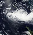
NASA sees Winston winding down near Norfolk Island
The once Category 5 Tropical Cyclone Winston was winding down when NASA-NOAA's Suomi NPP satellite passed over it early on Feb. 25 is it continued weakening in the South Pacific. Now sub-tropical, Winston was threatening Australia's Norfolk Island with tropical-storm-force winds. The Joint Typhoon Warning Center issued its final bulletin on Winston on Feb. 24 at 2100 UTC (4 p.m. EST), when the storm was located near 25.2 degrees south latitude and 172.8 degrees east longitude. Winston was becoming a sub-tropical storm at the time and had maximum sustained winds near 40 knots (46 mph/74 kph). It was moving to the southwest at 11 knots (12.6 mph/20.3 kph).
The Visible Infrared Imaging Radiometer Suite (VIIRS) instrument aboard NASA-NOAA's Suomi NPP satellite captured a visible image of Tropical Cyclone Winston on Feb. 25 that showed wind shear was adversely affecting the storm, and had pushed the bulk of system's clouds south of center. The VIIRS image also showed shallow clouds on the northern side of the storm. Despite the wind shear, Sub-tropical Storm Winston was threatening Norfolk Island, Australia.
Warnings were posted by the Australian Bureau of Meteorology (ABM) for Norfolk Island as Winston moved closer. A tropical cyclone warning was in effect for the island through Friday, February 25.
ABM stated that Winston is "expected to pass approximately 200 km (~124 miles) to the north of Norfolk Island Thursday night, Feb. 24 (local time) and move to about 300 km (186 miles) west-northwest of the Island early Friday morning, Feb. 25. It is expected to retain an intense wind structure and could still have similar impacts to a Category 1 tropical cyclone over Norfolk Island."
ABM noted that winds of up to 40 mph (65 kph) with higher gusts are expected to continue over Norfolk Island into the early hours of Friday. Winston is also expected to bring rough and dangerous surf that will likely produce significant beach erosion on exposed areas of the Island. For updated forecasts and warnings from ABM, visit: http://www.bom.gov.au.
Source: NASA/Goddard Space Flight Center
Articles on the same topic
- NASA's Terra satellite sees Tropical Cyclone Yalo coming to a quick endFri, 26 Feb 2016, 17:33:58 UTC
- NASA's Aqua satellite catches the birth of Tropical Cyclone YaloThu, 25 Feb 2016, 19:38:56 UTC
- NASA sees strong vertical wind shear battering a weaker winstonWed, 24 Feb 2016, 18:13:03 UTC
- NASA sees pinhole eye seen in weakening Tropical Cyclone WinstonWed, 24 Feb 2016, 18:12:55 UTC
- NASA sees category 5 southern Pacific Tropical cyclone hit FijiMon, 22 Feb 2016, 19:22:30 UTC
- NASA sees major Tropical Cyclone Winston approaching FijiFri, 19 Feb 2016, 22:53:32 UTC
- NASA infrared imagery shows wind shear affecting Tropical Cyclone UriahFri, 19 Feb 2016, 22:53:23 UTC
- NASA sees Tropical Cyclone Winston U-turn toward FijiFri, 19 Feb 2016, 22:53:14 UTC
- NASA catches Tropical Cyclone Uriah nearing peakFri, 19 Feb 2016, 22:52:53 UTC
- NASA sees Tropical Cyclone Winston intensifying near TongaFri, 19 Feb 2016, 22:52:43 UTC
Other sources
- NASA's Terra satellite sees Tropical Cyclone Yalo coming to a quick endfrom PhysorgFri, 26 Feb 2016, 18:01:39 UTC
- Aqua satellite catches the birth of Tropical Cyclone Yalofrom PhysorgThu, 25 Feb 2016, 19:30:38 UTC
- NASA sees Winston winding down near Norfolk Islandfrom PhysorgThu, 25 Feb 2016, 19:30:37 UTC
- NASA sees strong vertical wind shear battering a weaker winstonfrom PhysorgWed, 24 Feb 2016, 19:00:33 UTC
- NASA sees pinhole eye seen in weakening Tropical Cyclone Winstonfrom PhysorgTue, 23 Feb 2016, 18:30:39 UTC
- Monster Cyclone Winston Seen from Space (Photos)from Space.comTue, 23 Feb 2016, 14:50:27 UTC
- NASA sees category 5 southern Pacific Tropical cyclone hit Fijifrom PhysorgMon, 22 Feb 2016, 19:20:31 UTC
- Death toll in Fiji jumps to 20 as Cyclone Winston cleanup beginsfrom UPIMon, 22 Feb 2016, 14:30:36 UTC
- Death toll from Fiji cyclone hits 18 as aid sent to islandsfrom PhysorgMon, 22 Feb 2016, 9:30:32 UTC
- Major cyclone kills at least 10 in Fiji, destroys hundreds of homesfrom UPISun, 21 Feb 2016, 17:00:35 UTC
- Death toll from ferocious Fiji cyclone rises to 3from PhysorgSun, 21 Feb 2016, 9:30:38 UTC
- Powerful cyclone batters Fiji islands, maintains strengthfrom UPISat, 20 Feb 2016, 20:00:29 UTC
- Ferocious cyclone strikes Pacific island nation of Fijifrom PhysorgSat, 20 Feb 2016, 14:40:24 UTC
- Fiji hunkers down as formidable cyclone nears main islandsfrom PhysorgSat, 20 Feb 2016, 9:50:34 UTC
- Fiji hunkers down as formidable cyclone nears main islandsfrom AP ScienceSat, 20 Feb 2016, 4:00:28 UTC
- NASA sees major Tropical Cyclone Winston approaching Fijifrom PhysorgFri, 19 Feb 2016, 22:50:33 UTC
- NASA sees Tropical Cyclone Winston U-turn toward Fijifrom PhysorgThu, 18 Feb 2016, 21:01:03 UTC
- NASA catches Tropical Cyclone Uriah nearing peakfrom PhysorgWed, 17 Feb 2016, 19:42:51 UTC
- NASA sees Tropical Cyclone Winston intensifying near Tongafrom PhysorgWed, 17 Feb 2016, 19:42:49 UTC
