NASA sees pinhole eye seen in weakening Tropical Cyclone Winston
Related images
(click to enlarge)
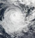
NOAA's Suomi NPP satellite saw that Tropical Cyclone Winston maintained a pinhole eye as it tracked east of southern Vanuatu's islands in the Southern Pacific Ocean on Feb. 23, 2016. Infrared imagery showed bands of strong thunderstorms were wrapping into the low-level center of the storm. On Feb. 23, 2016 at 0140 UTC (Feb. 22, 2016 at 8:40 p.m. EST) the Visible Infrared Imaging Radiometer Suite (VIIRS) instrument aboard NASA-NOAA's Suomi NPP satellite captured a visible image of Tropical Cyclone Winston that showed a pinhole eye as it was moving east of Vanuatu's southernmost islands.
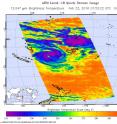
Animated enhanced infrared satellite imagery indicated a slowly-decaying low-level circulation center with curved strong bands of thunderstorms wrapping into the center of the storm. The Atmospheric Infrared Sounder or AIRS instrument that flies aboard NASA's Aqua satellite provided infrared temperature data on the system on Feb. 23, 2016 at 01:53 UTC (Feb. 22, 2016 at 8:53 p.m. EST). Some cloud top temperatures were colder than minus 63 Fahrenheit/ minus 53 Celsius, indicating they were high into the troposphere. Cloud top temperatures that cold have shown that those storms can produce heavy rainfall
Joint Typhoon Warning Center (JTWC) said that at 1500 GMT (10 a.m. EST) Winston's maximum sustained winds dropped to 70 knots (80.5 mph/129.6 kph) making it a Category 1 hurricane. It was located about 303 nautical miles (348 miles/561.2 km) west-southwest of Suva, Fiji near 20.7 degrees south latitude and 173.8 degrees east longitude. Winston had increased in forward speed since Feb. 22, 2016 and was moving to the south-southeast to 9 knots (10.3 mph/16.6 kph).
JTWC forecasters expect that Winston will turn southwestward to west-southwestward on Feb. 24, 2016 as it transitions to the steering influence of a building sub-tropical ridge (elongated area of high pressure) to the south. Tc 11p is expected to weaken significantly after Feb. 24, 2016 as it encounters strong vertical wind shear and cooler sea surface temperatures.
Source: NASA/Goddard Space Flight Center
Articles on the same topic
- NASA's Aqua satellite catches the birth of Tropical Cyclone Yalo9 years ago
- NASA sees Winston winding down near Norfolk Island9 years ago
- NASA sees strong vertical wind shear battering a weaker winston9 years ago
- NASA sees category 5 southern Pacific Tropical cyclone hit Fiji9 years ago
- NASA sees major Tropical Cyclone Winston approaching Fiji9 years ago
- NASA infrared imagery shows wind shear affecting Tropical Cyclone Uriah9 years ago
- NASA sees Tropical Cyclone Winston U-turn toward Fiji9 years ago
- NASA catches Tropical Cyclone Uriah nearing peak9 years ago
- NASA sees Tropical Cyclone Winston intensifying near Tonga9 years ago
Other sources
- Aqua satellite catches the birth of Tropical Cyclone Yalofrom Physorg9 years ago
- NASA sees Winston winding down near Norfolk Islandfrom Physorg9 years ago
- NASA sees strong vertical wind shear battering a weaker winstonfrom Physorg9 years ago
- NASA sees pinhole eye seen in weakening Tropical Cyclone Winstonfrom Physorg9 years ago
- Monster Cyclone Winston Seen from Space (Photos)from Space.com9 years ago
- NASA sees category 5 southern Pacific Tropical cyclone hit Fijifrom Physorg9 years ago
- Death toll in Fiji jumps to 20 as Cyclone Winston cleanup beginsfrom UPI9 years ago
- Death toll from Fiji cyclone hits 18 as aid sent to islandsfrom Physorg9 years ago
- Major cyclone kills at least 10 in Fiji, destroys hundreds of homesfrom UPI9 years ago
- Death toll from ferocious Fiji cyclone rises to 3from Physorg9 years ago
- Powerful cyclone batters Fiji islands, maintains strengthfrom UPI9 years ago
- Ferocious cyclone strikes Pacific island nation of Fijifrom Physorg9 years ago
- Fiji hunkers down as formidable cyclone nears main islandsfrom Physorg9 years ago
- Fiji hunkers down as formidable cyclone nears main islandsfrom AP Science9 years ago
- NASA sees major Tropical Cyclone Winston approaching Fijifrom Physorg9 years ago
- NASA sees Tropical Cyclone Winston U-turn toward Fijifrom Physorg9 years ago
- NASA catches Tropical Cyclone Uriah nearing peakfrom Physorg9 years ago
- NASA sees Tropical Cyclone Winston intensifying near Tongafrom Physorg9 years ago


