NASA infrared imagery shows wind shear affecting Tropical Cyclone Uriah
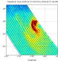
The Southern Indian Ocean's Tropical Cyclone Uriah is now past its peak and continues to weaken. Infrared satellite imagery from NASA revealed wind shear has already begun to take a toll on the storm. Wind shear began affecting Tropical Cyclone Uriah on February 17 as it reached its peak intensity. By February 18, increasing vertical wind shear's effect became more apparent. On Feb. 17 at 1800 UTC (1 p.m. EST), NASA's RapidScat instrument that flies aboard the International Space Station measured Tropical Cyclone Uriah's surface winds. RapidScat measures surface winds over open waters and found that strongest winds were near 30 meters per second (67.1 mph/ 108 kph) in the storm's southwestern quadrant. RapidScat also saw that tropical-storm-force winds were occurring out to 230 nautical miles from the center of circulation.
RapidScat is very helpful to forecasters because it can determine where the most powerful winds are located since winds are not equally distributed in tropical cyclones.
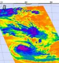
On Feb. 18 at 0811 UTC (3:11 a.m. EST) the Atmospheric Infrared Sounder or AIRS instrument aboard NASA's Aqua satellite looked at the storm in infrared light. AIRS data showed that Uriah's coldest cloud top temperatures appeared in strongest thunderstorms, south of the center of circulation. Those temperatures were colder than minus 63 degrees Fahrenheit (minus 53 degrees Celsius), and NASA research has shown that storms with cloud tops that cold and extending high into the troposphere have the capability to generate heavy rain.
The AIRS imagery also showed that moderate to strong vertical wind shear had pushed the bulk of clouds south of Uriah's center. The Joint Typhoon Warning Center (JTWC) noted "animated enhanced infrared satellite imagery indicates rapidly decaying (weakening) deep convection (rising air that condenses and forms clouds and thunderstorms that make up the tropical cyclone)."
By 1500 UTC (10 a.m. EST) Tropical Cyclone Uriah's winds had dropped from 125 knots (143.8 mph/ 231.5 kph) where it peaked, down to 90 knots (103.6 mph/166.7 kph). Uriah was centered near 22.3 degrees south latitude and 78.7 degrees east longitude, about 963 nautical miles (1,108 miles/ 1,783 km) south-southeast of Diego Garcia. Uriah was moving to the south at 11 knots (12.6 mph/20.3 kph).
Forecasters at the JTWC expect that Uriah will continue to move in a southerly direction and steadily weaken. Uriah is no threat to any land areas.
The storm is expected to dissipate by February 22.
Source: NASA/Goddard Space Flight Center
Articles on the same topic
- NASA's Terra satellite sees Tropical Cyclone Yalo coming to a quick endFri, 26 Feb 2016, 17:33:58 UTC
- NASA's Aqua satellite catches the birth of Tropical Cyclone YaloThu, 25 Feb 2016, 19:38:56 UTC
- NASA sees Winston winding down near Norfolk IslandThu, 25 Feb 2016, 19:38:38 UTC
- NASA sees strong vertical wind shear battering a weaker winstonWed, 24 Feb 2016, 18:13:03 UTC
- NASA sees pinhole eye seen in weakening Tropical Cyclone WinstonWed, 24 Feb 2016, 18:12:55 UTC
- NASA sees category 5 southern Pacific Tropical cyclone hit FijiMon, 22 Feb 2016, 19:22:30 UTC
- NASA sees major Tropical Cyclone Winston approaching FijiFri, 19 Feb 2016, 22:53:32 UTC
- NASA sees Tropical Cyclone Winston U-turn toward FijiFri, 19 Feb 2016, 22:53:14 UTC
- NASA catches Tropical Cyclone Uriah nearing peakFri, 19 Feb 2016, 22:52:53 UTC
- NASA sees Tropical Cyclone Winston intensifying near TongaFri, 19 Feb 2016, 22:52:43 UTC
Other sources
- NASA's Terra satellite sees Tropical Cyclone Yalo coming to a quick endfrom PhysorgFri, 26 Feb 2016, 18:01:39 UTC
- Aqua satellite catches the birth of Tropical Cyclone Yalofrom PhysorgThu, 25 Feb 2016, 19:30:38 UTC
- NASA sees Winston winding down near Norfolk Islandfrom PhysorgThu, 25 Feb 2016, 19:30:37 UTC
- NASA sees strong vertical wind shear battering a weaker winstonfrom PhysorgWed, 24 Feb 2016, 19:00:33 UTC
- NASA sees pinhole eye seen in weakening Tropical Cyclone Winstonfrom PhysorgTue, 23 Feb 2016, 18:30:39 UTC
- Monster Cyclone Winston Seen from Space (Photos)from Space.comTue, 23 Feb 2016, 14:50:27 UTC
- NASA sees category 5 southern Pacific Tropical cyclone hit Fijifrom PhysorgMon, 22 Feb 2016, 19:20:31 UTC
- Death toll in Fiji jumps to 20 as Cyclone Winston cleanup beginsfrom UPIMon, 22 Feb 2016, 14:30:36 UTC
- Death toll from Fiji cyclone hits 18 as aid sent to islandsfrom PhysorgMon, 22 Feb 2016, 9:30:32 UTC
- Major cyclone kills at least 10 in Fiji, destroys hundreds of homesfrom UPISun, 21 Feb 2016, 17:00:35 UTC
- Death toll from ferocious Fiji cyclone rises to 3from PhysorgSun, 21 Feb 2016, 9:30:38 UTC
- Powerful cyclone batters Fiji islands, maintains strengthfrom UPISat, 20 Feb 2016, 20:00:29 UTC
- Ferocious cyclone strikes Pacific island nation of Fijifrom PhysorgSat, 20 Feb 2016, 14:40:24 UTC
- Fiji hunkers down as formidable cyclone nears main islandsfrom PhysorgSat, 20 Feb 2016, 9:50:34 UTC
- Fiji hunkers down as formidable cyclone nears main islandsfrom AP ScienceSat, 20 Feb 2016, 4:00:28 UTC
- NASA sees major Tropical Cyclone Winston approaching Fijifrom PhysorgFri, 19 Feb 2016, 22:50:33 UTC
- NASA sees Tropical Cyclone Winston U-turn toward Fijifrom PhysorgThu, 18 Feb 2016, 21:01:03 UTC
- NASA catches Tropical Cyclone Uriah nearing peakfrom PhysorgWed, 17 Feb 2016, 19:42:51 UTC
- NASA sees Tropical Cyclone Winston intensifying near Tongafrom PhysorgWed, 17 Feb 2016, 19:42:49 UTC

