Satellite video shows Hurricane Sandra moving north along Mexico's west coast
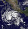
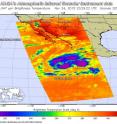
Tropical Storm Sandra formed on Nov. 24 and by the morning of Nov. 25 had become an Eastern Pacific Ocean late-season hurricane. NOAA's GOES-West satellite captured imagery of the storm from the time it developed to its status as a hurricane. On Nov. 24, the Atmospheric Infrared Sounder (AIRS) instrument aboard NASA's Aqua satellite captured infrared data on Tropical Storm Sandra as it was strengthening. Cloud top temperatures near -63F/-53C indicating powerful thunderstorms circled the center in the northern, eastern and southern quadrants of the storm.
National Hurricane Center (NHC) Forecaster Avila noted on Nov. 25 that even though an eye is not apparent on infrared imagery, the cloud pattern has continued to become better organized with the center of the cyclone embedded within an area of very deep convection. The outflow pattern continues to be established in all quadrants.
An animation of infrared and visible imagery from NOAA's GOES-West satellite taken over the period of Nov. 23 through 25 showed Post-tropical Storm Rick fading west of Baja California, while Hurricane Sandra moved up along the west-central Mexican coast on Nov. 24 and 25. The 33 second video was created by the NASA/NOAA GOES Project at NASA's Goddard Space Flight Center in Greenbelt, Maryland.
At 4 a.m. EST (0900 UTC) on Wednesday, November 25, 2015 the center of Hurricane Sandra was located near latitude 12.5 degrees north, longitude 109.0 degrees west. That's about 545 miles (880 km) southwest of Manzanillo, Mexico, and about 720 miles (1,160 km) south of the southern tip of Baja California, Mexico. The estimated minimum central pressure is 979 millibars.
Sandra was moving toward the west-northwest near 10 mph (17 kph) and is forecast to turn toward the north on Thursday. Maximum sustained winds have increased to near 85 mph (140 kph) and additional strengthening is forecast during the next 36 hours, and Sandra could become a major hurricane later today or Thursday, Nov. 26.
NHC noted that the cyclone should turn northwestward and northward around a ridge (elongated area of high pressure) later today, Nov. 25. The cyclone is expected to reach the mid-latitude westerlies in about 48 hours, and it should then sharply turn to the north-northeast and northeast toward the coast of Mexico. A landfall is currently forecast late Friday, Nov. 27 or early Saturday, Nov. 28 Pacific Standard Time.
Source: NASA/Goddard Space Flight Center
Articles on the same topic
- NASA sees small Tropical Storm In-fa becoming extra-tropicalWed, 25 Nov 2015, 16:34:57 UTC
- NASA's GPM gets a look at newborn, late season Eastern Pacific Tropical Storm SandraTue, 24 Nov 2015, 18:33:08 UTC
- NASA sees Tropical Storm Rick become a post-tropical lowMon, 23 Nov 2015, 16:22:48 UTC
- NASA's Aqua satellite eyes Tropical Storm Rick in Eastern PacificSun, 22 Nov 2015, 10:55:27 UTC
- Tropical Storm Rick joins an elite late-season storm groupSun, 22 Nov 2015, 10:54:25 UTC
- Twenty-first depression forms in eastern Pacific OceanSun, 22 Nov 2015, 10:54:04 UTC
Other sources
- NASA sees small Tropical Storm In-fa becoming extra-tropicalfrom PhysorgWed, 25 Nov 2015, 16:30:50 UTC
- Satellite video shows Hurricane Sandra moving north along Mexico's west coastfrom PhysorgWed, 25 Nov 2015, 16:00:16 UTC
- GPM gets a look at newborn, late season Eastern Pacific Tropical Storm Sandrafrom PhysorgTue, 24 Nov 2015, 18:30:12 UTC
- NASA eyes Tropical Cyclone Annabelle in Southern Indian Oceanfrom PhysorgMon, 23 Nov 2015, 21:30:28 UTC
- NASA sees Tropical Storm Rick become a post-tropical lowfrom PhysorgMon, 23 Nov 2015, 16:30:55 UTC
- Aqua satellite eyes Tropical Storm Rick in Eastern Pacificfrom PhysorgSun, 22 Nov 2015, 10:17:47 UTC
- Tropical Storm Rick joins an elite late-season storm groupfrom PhysorgThu, 19 Nov 2015, 18:10:28 UTC
- Twenty-first depression forms in eastern Pacific Oceanfrom PhysorgThu, 19 Nov 2015, 10:11:50 UTC

