NASA sees Tropical Storm Rick become a post-tropical low
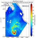
The remnants of post-tropical cyclone Rick continued to linger in the Eastern Pacific Ocean on November 23. An animation of visible and infrared imagery from NOAA's GOES-West satellite showed the weakening of Tropical Storm Rick into a remnant low pressure area from Nov. 21 to Nov. 23 in the Eastern Pacific Ocean, far off-shore from western Mexico. NASA's RapidScat instrument spotted the remnant's strongest winds on its eastern side on Nov. 22. Imagery from NOAA's GOES-West satellite were compiled into an animation at NASA's Goddard Space Flight Center in Greenbelt, Maryland. As the storm progressed northward, parallel to the coast of western Mexico, the development of thunderstorms had diminished over the three days.
The RapidScat instrument that flies aboard the International Space Station analyzed post-tropical cyclone Rick's surface winds on Nov. 22 at 11 a.m. EST (1600 UTC). RapidScat saw the strongest winds were near 15 meters per second (33.5 mph/54 kph) east of the center. Winds on the western side of the storm were only between 6 and 12 meters per second (13.4 and 26.8 mph/21.6 and 43 kph).
The National Hurricane Center issued the final bulletin on Tropical Cyclone Rick at 4 p.m. EST (1 p.m. PST/2100 UTC) on Nov. 22. At that time the center of Post-Tropical Cyclone Rick was located near latitude 18.1 north, longitude 119.1 west. That's about 680 miles (1,095 km) west-southwest of the southern tip of Baja California. The low was moving toward the northwest near 8 mph (13 kph). A turn north is expected. Maximum sustained winds were near 35 mph (55 kph) and the remnant low is expected to dissipate in a few days.
On Monday, Nov. 23, Rick's post-tropical remnant low pressure area was near 19 degrees north latitude and 120 degrees west longitude. The remnant low had a minimum central pressure near 1007 millibars. Maximum sustained winds were near 20 knots (23 mph/37 kph) in the northeastern and southwestern quadrants.
For additional information on the remnant low please see High Seas Forecasts issued by the National Weather Service, under AWIPS header NFDHSFEPI, WMO header FZPN01 KWBC, and on the web at http://www.opc.ncep.noaa.gov/shtml/NFDHSFEP1.shtml.
Source: NASA/Goddard Space Flight Center
Articles on the same topic
- NASA sees small Tropical Storm In-fa becoming extra-tropicalWed, 25 Nov 2015, 16:34:57 UTC
- Satellite video shows Hurricane Sandra moving north along Mexico's west coastWed, 25 Nov 2015, 15:31:41 UTC
- NASA's GPM gets a look at newborn, late season Eastern Pacific Tropical Storm SandraTue, 24 Nov 2015, 18:33:08 UTC
- NASA's Aqua satellite eyes Tropical Storm Rick in Eastern PacificSun, 22 Nov 2015, 10:55:27 UTC
- Tropical Storm Rick joins an elite late-season storm groupSun, 22 Nov 2015, 10:54:25 UTC
- Twenty-first depression forms in eastern Pacific OceanSun, 22 Nov 2015, 10:54:04 UTC
Other sources
- NASA sees small Tropical Storm In-fa becoming extra-tropicalfrom PhysorgWed, 25 Nov 2015, 16:30:50 UTC
- Satellite video shows Hurricane Sandra moving north along Mexico's west coastfrom PhysorgWed, 25 Nov 2015, 16:00:16 UTC
- GPM gets a look at newborn, late season Eastern Pacific Tropical Storm Sandrafrom PhysorgTue, 24 Nov 2015, 18:30:12 UTC
- NASA eyes Tropical Cyclone Annabelle in Southern Indian Oceanfrom PhysorgMon, 23 Nov 2015, 21:30:28 UTC
- NASA sees Tropical Storm Rick become a post-tropical lowfrom PhysorgMon, 23 Nov 2015, 16:30:55 UTC
- Aqua satellite eyes Tropical Storm Rick in Eastern Pacificfrom PhysorgSun, 22 Nov 2015, 10:17:47 UTC
- Tropical Storm Rick joins an elite late-season storm groupfrom PhysorgThu, 19 Nov 2015, 18:10:28 UTC
- Twenty-first depression forms in eastern Pacific Oceanfrom PhysorgThu, 19 Nov 2015, 10:11:50 UTC
