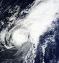
NASA sees small Tropical Storm In-fa becoming extra-tropical
Tropical Storm In-fa was becoming an extra-tropical storm as it tracked toward the island of Iwo To, Japan in the western North Pacific Ocean. NASA's Terra satellite captured an infrared image of the small storm that is battling wind shear and was becoming extra-tropical. The Moderate Resolution Imaging Spectroradiometer aboard NASA's Terra satellite passed over In-fa on Nov. 25 and captured an infrared image of the small storm as it was being affected by strong southwesterly wind shear. Tropical-storm-force winds only extended out 85 miles from the center. The MODIS image also showed that strong convection and thunderstorms continued to be pushed northeast of the center. In-fa is located in an area of strong (30 to 40 knots/34.5 to 46 mph/55.5 to 74 kph) southwesterly vertical wind shear.
At 1500 UTC (10 a.m. EST), Tropical storm In-fa was centered near 20.6 degrees north latitude and 137.1 degrees east longitude, about 343 nautical miles (394 miles/635 km) southwest of Iwo To, Japan. In-fa was moving to the east-northeast at 12 knots (13.8 mph/22.2 kph) and maximum sustained winds were down to 40 knots (46 mph/74 kph).
When a tropical cyclone becomes extra-tropical it has lost its "tropical" characteristics. According to the National Oceanic and Atmospheric Administration, the term "extra-tropical" implies both poleward displacement (it moves closer to the north or south pole depending on what hemisphere it is located in) of the cyclone and the conversion of the cyclone's primary energy source from the release of latent heat of condensation to baroclinic (the temperature contrast between warm and cold air masses) processes. Cyclones can become extra-tropical and still retain winds of hurricane or tropical storm force.
In-fa was moving east-northeast and forecasters at the Joint Typhoon Warning Center expect it to pass just south of the island of Iwo To, Japan on Nov. 26.
For the latest conditions in Iwo To (Iwojima), visit NOAA's National Weather Service page: http://weather.noaa.gov/weather/current/RJAW.html.
Source: NASA/Goddard Space Flight Center
Articles on the same topic
- Satellite video shows Hurricane Sandra moving north along Mexico's west coastWed, 25 Nov 2015, 15:31:41 UTC
- NASA's GPM gets a look at newborn, late season Eastern Pacific Tropical Storm SandraTue, 24 Nov 2015, 18:33:08 UTC
- NASA sees Tropical Storm Rick become a post-tropical lowMon, 23 Nov 2015, 16:22:48 UTC
- NASA's Aqua satellite eyes Tropical Storm Rick in Eastern PacificSun, 22 Nov 2015, 10:55:27 UTC
- Tropical Storm Rick joins an elite late-season storm groupSun, 22 Nov 2015, 10:54:25 UTC
- Twenty-first depression forms in eastern Pacific OceanSun, 22 Nov 2015, 10:54:04 UTC
Other sources
- NASA sees small Tropical Storm In-fa becoming extra-tropicalfrom PhysorgWed, 25 Nov 2015, 16:30:50 UTC
- Satellite video shows Hurricane Sandra moving north along Mexico's west coastfrom PhysorgWed, 25 Nov 2015, 16:00:16 UTC
- GPM gets a look at newborn, late season Eastern Pacific Tropical Storm Sandrafrom PhysorgTue, 24 Nov 2015, 18:30:12 UTC
- NASA eyes Tropical Cyclone Annabelle in Southern Indian Oceanfrom PhysorgMon, 23 Nov 2015, 21:30:28 UTC
- NASA sees Tropical Storm Rick become a post-tropical lowfrom PhysorgMon, 23 Nov 2015, 16:30:55 UTC
- Aqua satellite eyes Tropical Storm Rick in Eastern Pacificfrom PhysorgSun, 22 Nov 2015, 10:17:47 UTC
- Tropical Storm Rick joins an elite late-season storm groupfrom PhysorgThu, 19 Nov 2015, 18:10:28 UTC
- Twenty-first depression forms in eastern Pacific Oceanfrom PhysorgThu, 19 Nov 2015, 10:11:50 UTC
