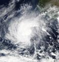
NASA's Aqua satellite eyes Tropical Storm Rick in Eastern Pacific
NASA's Aqua satellite passed over Rick and captured a visible light image that showed the storm far off the coast of western Mexico. Rick continued to hang on to its status as tropical storm on Nov. 20, although a minimal one. The MODIS instrument aboard NASA's Aqua satellite captured a visible image of Tropical Storm Rick on Nov. 19 at 20:15 UTC (3:15 p.m. EST). The image showed thunderstorms circling the low-level center, and a larger band of thunderstorms feeding into the center from the northeast.
Forecaster Berg of the National Hurricane Center said that banding of thunderstorms appears better defined on Friday, Nov. 20. Recent scatterometer data, which measures surface winds, indicate that the maximum winds remain about 35 knots (40 mph), with the tropical-storm-force winds confined to a small area west of the center.
At 4 a.m. EST (0900 UTC) on Nov. 20, the center of Tropical Storm Rick was located near latitude 15.9 North, longitude 109.4 West. That's about 400 miles (640 km) west-southwest of Manzanillo, Mexico. Rick was moving toward the west-northwest near 13 mph (20 kph), and this general motion with a gradual decrease in forward speed is expected through Saturday night.
Maximum sustained winds remain near 40 mph (65 kph) with higher gusts. The National Hurricane Center said that little change in strength is forecast during the next 48 hours. The estimated minimum central pressure is 1002 millibars.
Rick is expected to remain far from land over the next two days and weaken to a depression by Nov. 22.
For forecast updates, visit the National Hurricane Center website at: http://www.nhc.noaa.gov.
Source: NASA/Goddard Space Flight Center
Articles on the same topic
- NASA sees small Tropical Storm In-fa becoming extra-tropicalWed, 25 Nov 2015, 16:34:57 UTC
- Satellite video shows Hurricane Sandra moving north along Mexico's west coastWed, 25 Nov 2015, 15:31:41 UTC
- NASA's GPM gets a look at newborn, late season Eastern Pacific Tropical Storm SandraTue, 24 Nov 2015, 18:33:08 UTC
- NASA sees Tropical Storm Rick become a post-tropical lowMon, 23 Nov 2015, 16:22:48 UTC
- Tropical Storm Rick joins an elite late-season storm groupSun, 22 Nov 2015, 10:54:25 UTC
- Twenty-first depression forms in eastern Pacific OceanSun, 22 Nov 2015, 10:54:04 UTC
Other sources
- NASA sees small Tropical Storm In-fa becoming extra-tropicalfrom PhysorgWed, 25 Nov 2015, 16:30:50 UTC
- Satellite video shows Hurricane Sandra moving north along Mexico's west coastfrom PhysorgWed, 25 Nov 2015, 16:00:16 UTC
- GPM gets a look at newborn, late season Eastern Pacific Tropical Storm Sandrafrom PhysorgTue, 24 Nov 2015, 18:30:12 UTC
- NASA eyes Tropical Cyclone Annabelle in Southern Indian Oceanfrom PhysorgMon, 23 Nov 2015, 21:30:28 UTC
- NASA sees Tropical Storm Rick become a post-tropical lowfrom PhysorgMon, 23 Nov 2015, 16:30:55 UTC
- Aqua satellite eyes Tropical Storm Rick in Eastern Pacificfrom PhysorgSun, 22 Nov 2015, 10:17:47 UTC
- Tropical Storm Rick joins an elite late-season storm groupfrom PhysorgThu, 19 Nov 2015, 18:10:28 UTC
- Twenty-first depression forms in eastern Pacific Oceanfrom PhysorgThu, 19 Nov 2015, 10:11:50 UTC
