NASA's GPM gets a look at newborn, late season Eastern Pacific Tropical Storm Sandra
During the early morning of Nov. 24, Tropical Storm Sandra became the 18th named storm of the 2015 Eastern Pacific hurricane season. NASA's Global Precipitation Measurement or GPM mission core satellite passed over the new storm and looked at its clouds and rainfall. At 4 p.m. EST (2100 UTC) on Nov. 23, Tropical Depression Twenty-Two-E was born near latitude 10.8 north, longitude 102.9 west. Twelve hours later it strengthened into a tropical storm.
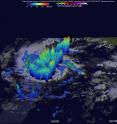
Intensifying Tropical Storm Sandra had winds of about 35 knots (40 mph/62 kph) when the GPM core observatory satellite passed over on November 24, 2015 at 0719 UTC (2:19 a.m. EST). A rainfall analysis was created using data collected from GPM's Microwave Imager (GMI) and Dual-Frequency Precipitation Radar (DPR) instruments. DPR discovered that the intense convective storms south of the tropical storm's center of circulation were dropping rain at a rate of over 80 mm (3.1 inches) per hour.
The tops of some convective storms within Sandra's circulation reached heights above 16 km (9.9 miles). At NASA's Goddard Space Flight Center in Greenbelt, Maryland a 3-D cross-section image was created using GPM's radar data (DPR Ku band) that showed several other powerful thunderstorms were also reaching heights of over 15 km (9.3 miles). GPM is co-managed with the Japan Aerospace Exploration Agency.
At 10 a.m. EST (1500 UTC) on Nov. 24, the center of Tropical Storm Sandra was located near latitude 11.2 North, longitude 106.1 West. That puts the center about 550 miles (890 km) south-southwest of Manzanillo, Mexico and about 845 miles (1,360 km) south-southeast of the southern tip of Baja California, Mexico. Sandra is far enough away from land that there are no coastal watches or warnings in effect.
Maximum sustained winds have increased to near 50 mph (85 kph) and is forecast to strengthen into a hurricane by Wednesday, Nov. 25. The National Hurricane Center (NHC) noted that Sandra was moving toward the west near 13 mph (20 kph) and expected to turn west-northwest then northwest and north-northwest by Wednesday and Wednesday night.
Tropical Storm Sandra is in an area of warm ocean water and light vertical wind shear that promotes intensification. At 10 a.m. EST on Nov. 24, NHC forecaster Berg said that the environment appears well suited for Sandra to continue strengthening during the next 48 hours. Sea surface temperatures along the forecast track will be between 29 and 30 degrees Celsius, and the vertical shear is expected to be less than 10 knots for the next two days. Therefore, steady strengthening is shown through 48 hours, with Sandra potentially peaking as a category 2 hurricane around that time.
For updated forecasts, visit: http://www.nhc.noaa.gov
Source: NASA/Goddard Space Flight Center
Articles on the same topic
- NASA sees small Tropical Storm In-fa becoming extra-tropicalWed, 25 Nov 2015, 16:34:57 UTC
- Satellite video shows Hurricane Sandra moving north along Mexico's west coastWed, 25 Nov 2015, 15:31:41 UTC
- NASA sees Tropical Storm Rick become a post-tropical lowMon, 23 Nov 2015, 16:22:48 UTC
- NASA's Aqua satellite eyes Tropical Storm Rick in Eastern PacificSun, 22 Nov 2015, 10:55:27 UTC
- Tropical Storm Rick joins an elite late-season storm groupSun, 22 Nov 2015, 10:54:25 UTC
- Twenty-first depression forms in eastern Pacific OceanSun, 22 Nov 2015, 10:54:04 UTC
Other sources
- NASA sees small Tropical Storm In-fa becoming extra-tropicalfrom PhysorgWed, 25 Nov 2015, 16:30:50 UTC
- Satellite video shows Hurricane Sandra moving north along Mexico's west coastfrom PhysorgWed, 25 Nov 2015, 16:00:16 UTC
- GPM gets a look at newborn, late season Eastern Pacific Tropical Storm Sandrafrom PhysorgTue, 24 Nov 2015, 18:30:12 UTC
- NASA eyes Tropical Cyclone Annabelle in Southern Indian Oceanfrom PhysorgMon, 23 Nov 2015, 21:30:28 UTC
- NASA sees Tropical Storm Rick become a post-tropical lowfrom PhysorgMon, 23 Nov 2015, 16:30:55 UTC
- Aqua satellite eyes Tropical Storm Rick in Eastern Pacificfrom PhysorgSun, 22 Nov 2015, 10:17:47 UTC
- Tropical Storm Rick joins an elite late-season storm groupfrom PhysorgThu, 19 Nov 2015, 18:10:28 UTC
- Twenty-first depression forms in eastern Pacific Oceanfrom PhysorgThu, 19 Nov 2015, 10:11:50 UTC
