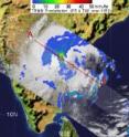
NASA's TRMM sees heavy rainfall in Cyclone Laila's India landfall
NASA's Tropical Rainfall Measuring Mission or TRMM satellite captured a satellite image of Laila's rainfall and revealed some areas of heavy rainfall. TRMM not only measures rainfall intensity from space but can also give scientists an idea about the height of a thunderstorm that is generating the rainfall within the tropical cyclone. Tropical cyclones are made up of hundreds of thunderstorms.
A "hot tower" is a rain cloud that reaches at least to the top of the troposphere, the lowest layer of the atmosphere. It extends approximately nine miles (14.5 kilometers) high in the tropics. These towers are called "hot" because they rise to such altitude due to the large amount of latent heat. Water vapor releases this latent heat as it condenses into liquid.
On May 20 at 0714 UTC (3:14 a.m. EDT) TRMM flew over Laila after it made landfall in India and captured an image of its rainfall rates. The heaviest rainfall appeared just southeast of the center of circulation, and over land (along the coast). That area was generating rainfall of about 2 inches per hour.
Rain rates are created from different instruments aboard TRMM. The rain rates in the center of TRMM images are derived from the TRMM Precipitation Radar, the only space borne radar of its kind, while those in the outer portion are from the TRMM Microwave Imager. The rain rates are then overlaid on infrared data from the TRMM Visible Infrared Scanner to create the entire image. The images are created at NASA's Goddard Space Flight Center, in Greenbelt, Md.
At 9:00 UTC (5 a.m. EDT) Laila had maximum sustained winds near 50 knots (57 mph). The center of Tropical Storm Laila was close to the town of Bapatla. Bapatla is one of the historical towns and mandals of Guntur District (Andhra Pradesh) located 40 miles south of Guntur City on the East Coast of India. It is also about 220 nautical miles west-southwest of Visakhapatnam, near 16.0 North and 80.1 East.
Laila was moving north-northwestward at 10 knots (12 mph). The Joint Typhoon Warning Center noted that as Laila "follows this path it will encounter the rugged terrain of northeastern Andhra Pradesh and weaken. However, a formidable remnant low is expected to reemerge over the northern Bay of Bengal after 72 hours and accelerate east-northeastward toward eventual landfall over or near south-eastern Bangladesh."
Residents along coastal areas of Andhra Pradesh and Telangana in other areas in Laila's path can expected widespread heavy rainfall and gusty winds. Seas will also be rough, and fishermen were advised by the India Meteorological Department to stay out of the ocean.
Source: NASA/Goddard Space Flight Center
Articles on the same topic
- NASA's Aqua satellite sees Tropical Storm 02A's high thunderstormsThu, 20 May 2010, 20:27:29 UTC
- NASA's Aqua satellite sees second tropical storm form near the Horn of AfricaWed, 19 May 2010, 19:19:43 UTC
- Cyclone Laila, formerly Tropical Storm 1B, is headed for landfall in IndiaWed, 19 May 2010, 19:19:42 UTC
- NASA's Aqua satellite sees Tropical Storm 1B form in Bay of BengalTue, 18 May 2010, 20:34:13 UTC
Other sources
- NASA's TRMM sees heavy rainfall in Cyclone Laila's India landfallfrom Science BlogThu, 20 May 2010, 23:00:33 UTC
- NASA's Aqua satellite sees Tropical Storm 02A's high thunderstormsfrom Science BlogThu, 20 May 2010, 23:00:27 UTC
- NASA's TRMM sees heavy rainfall in Cyclone Laila's India landfallfrom PhysorgThu, 20 May 2010, 21:31:13 UTC
- NASA's Aqua satellite sees Tropical Storm 02A's high thunderstormsfrom PhysorgThu, 20 May 2010, 21:02:00 UTC
- NASA's Aqua satellite sees second tropical storm form near the Horn of Africafrom Science BlogThu, 20 May 2010, 0:31:04 UTC
- Cyclone Laila, formerly Tropical Storm 1B, is headed for landfall in Indiafrom Science BlogWed, 19 May 2010, 20:01:10 UTC
- NASA's Aqua satellite sees second tropical storm form near the Horn of Africafrom Science BlogWed, 19 May 2010, 20:00:45 UTC
- Aqua satellite sees second tropical storm form near the Horn of Africafrom PhysorgWed, 19 May 2010, 19:32:09 UTC
- Cyclone Laila, formerly Tropical Storm 1B, is headed for landfall in Indiafrom PhysorgWed, 19 May 2010, 18:53:43 UTC
- Aqua satellite sees Tropical Storm 1B form in Bay of Bengalfrom PhysorgTue, 18 May 2010, 21:30:53 UTC
- NASA's Aqua satellite sees Tropical Storm 1B form in Bay of Bengalfrom Science BlogTue, 18 May 2010, 20:30:44 UTC
