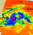
NASA's Aqua satellite sees Tropical Storm 02A's high thunderstorms
NASA's Aqua satellite saw some strong thunderstorms in Tropical Storm 02A using infrared imagery, as it heads into the Gulf of Aden between Somalia and Yemen. At 1500 UTC (11 a.m. EDT), Tropical Storm 2A was packing maximum sustained winds near 45 knots (52 mph). Tropical storm-force winds extend out to 45 miles from the center. It is located near 12.6 North and 51.5 East in the Arabian Sea, passing by Cape Guardafui on the northeast tip of Somalia. It was moving in a west-northwest direction at 7 mph (6 knots), and moving into the Gulf of Aden. 2A's winds are kicking up waves in the Gulf of Aden and western Arabian Sea up to 15 feet high.
NASA's Aqua satellite flew over Tropical Storm 02A on May 19 at 21:59 UTC (5:59 p.m. EDT) and the Atmospheric Infrared Sounder known as the AIRS instrument captured an infrared image of the storm. The infrared image showed 02A has some stronger thunderstorms around its center. Additionally, the image showed warm waters of more than 80 degrees Fahrenheit (threshold for maintaining tropical cyclones) in the Gulf of Aden and western Arabian Sea. The imagery also showed much warmer land temperatures in Yemen to the storm's north.
Once 02A gets into the Gulf of Aden, forecasters at the Joint Typhoon Warning Center expect the storm will strengthen for a brief period before it runs into wind shear, which is expected to weaken it.
Source: NASA/Goddard Space Flight Center
Articles on the same topic
- NASA's TRMM sees heavy rainfall in Cyclone Laila's India landfallThu, 20 May 2010, 20:27:26 UTC
- NASA's Aqua satellite sees second tropical storm form near the Horn of AfricaWed, 19 May 2010, 19:19:43 UTC
- Cyclone Laila, formerly Tropical Storm 1B, is headed for landfall in IndiaWed, 19 May 2010, 19:19:42 UTC
- NASA's Aqua satellite sees Tropical Storm 1B form in Bay of BengalTue, 18 May 2010, 20:34:13 UTC
Other sources
- NASA's TRMM sees heavy rainfall in Cyclone Laila's India landfallfrom Science BlogThu, 20 May 2010, 23:00:33 UTC
- NASA's Aqua satellite sees Tropical Storm 02A's high thunderstormsfrom Science BlogThu, 20 May 2010, 23:00:27 UTC
- NASA's TRMM sees heavy rainfall in Cyclone Laila's India landfallfrom PhysorgThu, 20 May 2010, 21:31:13 UTC
- NASA's Aqua satellite sees Tropical Storm 02A's high thunderstormsfrom PhysorgThu, 20 May 2010, 21:02:00 UTC
- NASA's Aqua satellite sees second tropical storm form near the Horn of Africafrom Science BlogThu, 20 May 2010, 0:31:04 UTC
- Cyclone Laila, formerly Tropical Storm 1B, is headed for landfall in Indiafrom Science BlogWed, 19 May 2010, 20:01:10 UTC
- NASA's Aqua satellite sees second tropical storm form near the Horn of Africafrom Science BlogWed, 19 May 2010, 20:00:45 UTC
- Aqua satellite sees second tropical storm form near the Horn of Africafrom PhysorgWed, 19 May 2010, 19:32:09 UTC
- Cyclone Laila, formerly Tropical Storm 1B, is headed for landfall in Indiafrom PhysorgWed, 19 May 2010, 18:53:43 UTC
- Aqua satellite sees Tropical Storm 1B form in Bay of Bengalfrom PhysorgTue, 18 May 2010, 21:30:53 UTC
- NASA's Aqua satellite sees Tropical Storm 1B form in Bay of Bengalfrom Science BlogTue, 18 May 2010, 20:30:44 UTC
