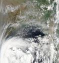
NASA's Aqua satellite sees Tropical Storm 1B form in Bay of Bengal
The first tropical storm of the Northern Indian Ocean cyclone season has formed and NASA's Aqua satellite captured its birth. Tropical Storm 1B formed in the early morning hours as the convection around the low level circulation center increased since May 17. NASA's Aqua satellite captured a visible image of 1B from the Moderate Resolution Imaging Spectroradiometer (MODIS) at 7:25 UTC (12:25 p.m. Asia/Kolkata time) today, May 18, where if formed off of India's east coast in the Bay of Bengal.
At 09:00 UTC (5 a.m. EDT or 2 p.m. Asia/Kolkata local time) on May 18, Tropical Storm 1B had maximum sustained winds near 40 knots (46 mph). It was located about 285 nautical miles east-southeast of Chennai, India near 12.4 North and 84.5 East in the Bay of Bengal. It is moving west-northwest near 13 knots (15 mph) and is forecast to continue in that direction, according to the Joint Typhoon Warning Center, the organization the forecasts tropical cyclones in that region.
Tropical Storm 1B is expected to intensify in the next two days as it moves closer to Chennai. It is then forecast to make landfall south of Visakhapatham.
Source: NASA/Goddard Space Flight Center
Articles on the same topic
- NASA's Aqua satellite sees Tropical Storm 02A's high thunderstormsThu, 20 May 2010, 20:27:29 UTC
- NASA's TRMM sees heavy rainfall in Cyclone Laila's India landfallThu, 20 May 2010, 20:27:26 UTC
- NASA's Aqua satellite sees second tropical storm form near the Horn of AfricaWed, 19 May 2010, 19:19:43 UTC
- Cyclone Laila, formerly Tropical Storm 1B, is headed for landfall in IndiaWed, 19 May 2010, 19:19:42 UTC
Other sources
- NASA's TRMM sees heavy rainfall in Cyclone Laila's India landfallfrom Science BlogThu, 20 May 2010, 23:00:33 UTC
- NASA's Aqua satellite sees Tropical Storm 02A's high thunderstormsfrom Science BlogThu, 20 May 2010, 23:00:27 UTC
- NASA's TRMM sees heavy rainfall in Cyclone Laila's India landfallfrom PhysorgThu, 20 May 2010, 21:31:13 UTC
- NASA's Aqua satellite sees Tropical Storm 02A's high thunderstormsfrom PhysorgThu, 20 May 2010, 21:02:00 UTC
- NASA's Aqua satellite sees second tropical storm form near the Horn of Africafrom Science BlogThu, 20 May 2010, 0:31:04 UTC
- Cyclone Laila, formerly Tropical Storm 1B, is headed for landfall in Indiafrom Science BlogWed, 19 May 2010, 20:01:10 UTC
- NASA's Aqua satellite sees second tropical storm form near the Horn of Africafrom Science BlogWed, 19 May 2010, 20:00:45 UTC
- Aqua satellite sees second tropical storm form near the Horn of Africafrom PhysorgWed, 19 May 2010, 19:32:09 UTC
- Cyclone Laila, formerly Tropical Storm 1B, is headed for landfall in Indiafrom PhysorgWed, 19 May 2010, 18:53:43 UTC
- Aqua satellite sees Tropical Storm 1B form in Bay of Bengalfrom PhysorgTue, 18 May 2010, 21:30:53 UTC
- NASA's Aqua satellite sees Tropical Storm 1B form in Bay of Bengalfrom Science BlogTue, 18 May 2010, 20:30:44 UTC
