Tropical Storm 23S born in Southern Indian Ocean
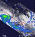
According to data from the Tropical Rainfall Measuring Mission, or TRMM satellite mostly light to moderate rain is falling in the latest tropical cyclone born in the waters of the Southern Indian Ocean. TRMM can measure rainfall from its vantage point in space as it orbits the Earth and forecasters will be using TRMM data to continue monitoring the storm's intensity. Tropical Storm 23S was born today, April 2 about 260 nautical miles west of Cocos Island, Australia, near 11.5 South and 92.5 East. It has maximum sustained winds of 39 mph (35 knots) and is moving southward at around 6 mph (5 knots). Although Cocos Island is not in the direct path of the storm, it was being affected with by thunderstorms in the storm's outer bands.
When the TRMM satellite passed over Tropical Storm 23S on April 2 at 0913 UTC (5:13 a.m. EDT) it measured light to moderate rainfall. Since then, infrared satellite imagery indicated that bands of thunderstorms have consolidated around the center of 23S's center of circulation. Rainfall is likely going to intensify in the system as it strengthens over the weekend. At times rain may be falling in some areas of the storm at up to 2 inches per hour.
Over the weekend, 23S is forecast to track south and intensify, according to the Joint Typhoon Warning Center. By Monday, 23S will run into a mid-latitude trough, or extended area of low pressure that will weaken it.
Source: NASA/Goddard Space Flight Center
Articles on the same topic
- NASA's TRMM satellite maps Cyclone Paul's extreme rainfall totals in AustraliaFri, 2 Apr 2010, 19:22:20 UTC
- Warnings dropped for ex-cyclone Paul as NASA satellites see it fizzleThu, 1 Apr 2010, 20:50:42 UTC
- TRMM satellite sees Paul's low headed back to Gulf of CarpentariaWed, 31 Mar 2010, 15:46:33 UTC
- TRMM measures Cyclone Paul's rainfall from spaceTue, 30 Mar 2010, 21:50:40 UTC
Other sources
- NASA's TRMM satellite maps Cyclone Paul's extreme rainfall totals in Australiafrom Science BlogFri, 2 Apr 2010, 19:56:19 UTC
- Tropical Storm 23S born in Southern Indian Oceanfrom Science BlogFri, 2 Apr 2010, 19:56:17 UTC
- NASA's TRMM satellite maps Cyclone Paul's extreme rainfall totals in Australiafrom PhysorgFri, 2 Apr 2010, 19:35:21 UTC
- Tropical Storm 23S born in Southern Indian Oceanfrom PhysorgFri, 2 Apr 2010, 19:14:17 UTC
- TRMM satellite sees Paul's low headed back to Gulf of Carpentariafrom Science BlogWed, 31 Mar 2010, 16:56:58 UTC
- TRMM satellite sees Paul's low headed back to Gulf of Carpentariafrom PhysorgWed, 31 Mar 2010, 16:35:18 UTC
- TRMM measures Cyclone Paul's rainfall from spacefrom Science BlogTue, 30 Mar 2010, 22:14:25 UTC
- TRMM measures Cyclone Paul's rainfall from spacefrom PhysorgTue, 30 Mar 2010, 21:49:09 UTC
