Warnings dropped for ex-cyclone Paul as NASA satellites see it fizzle
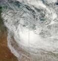
NASA's Aqua satellite flew over the remnants of ex-tropical storm Paul early today, April 1 and noticed its circulation and form had weakened in the last 24 hours. All weather warnings for the mainland in the Northern Territory have been cancelled. The Moderate Resolution Imaging Spectroradiometer or MODIS instrument on NASA's Aqua satellite captured a visible image of the remnants of Cyclone Paul over the Gulf of Carpentaria, Australia at 04:45 UTC (12:45 a.m. EDT) today, April 1, 2010. The image showed that most of the clouds associated with the low were on the southern side of the circulation and over land.
Another instrument on NASA's Aqua satellite also got a good look at Paul's remnants as the satellite flew overhead. The Atmospheric Infrared Sounder, or AIRS instrument captured an infrared image of Paul's cold remnant thunderstorm cloud tops. The infrared image, which shows temperatures, indicated that the strongest thunderstorms were still over land in the Northern Territory. The image also showed very warm land to Paul's west and south.
The only warnings in effect are for the coastal waters, where there is a wind warning posted from Coastal Nhulunbuy to the Queensland border. The warning means that winds from the west-southwest will be gusting to 20-30 knots (23- 34 mph/ 37-55 kph), easing below 25 knots (28 mph/46 kph) during Friday morning (local Darwin time). Seas are expected to be as high as 3 meters (9 feet), but the conditions are expected to ease on Friday.
On April 1 at 11:15 p.m. CST Darwin time (8:45 a.m. EDT) Paul's remnants were located close to the Northern Territory/Queensland border in the southern Gulf of Carpentaria coast. The low is expected to track inland overnight and continue to weaken over the southern Top End during the next few days.
Paul is now not expected to redevelop into a tropical cyclone.
Source: NASA/Goddard Space Flight Center
Articles on the same topic
- Tropical Storm 23S born in Southern Indian OceanFri, 2 Apr 2010, 19:22:21 UTC
- NASA's TRMM satellite maps Cyclone Paul's extreme rainfall totals in AustraliaFri, 2 Apr 2010, 19:22:20 UTC
- TRMM satellite sees Paul's low headed back to Gulf of CarpentariaWed, 31 Mar 2010, 15:46:33 UTC
- TRMM measures Cyclone Paul's rainfall from spaceTue, 30 Mar 2010, 21:50:40 UTC
Other sources
- NASA's TRMM satellite maps Cyclone Paul's extreme rainfall totals in Australiafrom Science BlogFri, 2 Apr 2010, 19:56:19 UTC
- Tropical Storm 23S born in Southern Indian Oceanfrom Science BlogFri, 2 Apr 2010, 19:56:17 UTC
- NASA's TRMM satellite maps Cyclone Paul's extreme rainfall totals in Australiafrom PhysorgFri, 2 Apr 2010, 19:35:21 UTC
- Tropical Storm 23S born in Southern Indian Oceanfrom PhysorgFri, 2 Apr 2010, 19:14:17 UTC
- TRMM satellite sees Paul's low headed back to Gulf of Carpentariafrom Science BlogWed, 31 Mar 2010, 16:56:58 UTC
- TRMM satellite sees Paul's low headed back to Gulf of Carpentariafrom PhysorgWed, 31 Mar 2010, 16:35:18 UTC
- TRMM measures Cyclone Paul's rainfall from spacefrom Science BlogTue, 30 Mar 2010, 22:14:25 UTC
- TRMM measures Cyclone Paul's rainfall from spacefrom PhysorgTue, 30 Mar 2010, 21:49:09 UTC
