TRMM satellite sees Paul's low headed back to Gulf of Carpentaria
NASA's Tropical Rainfall Measuring Mission satellite, better known as TRMM has been tracking Cyclone Paul's rainfall over the last week, and has watched is it made landfall in the Northern Territory and is now tracking Paul as it heads back toward the Gulf of Carpentaria for a return over water. The Australian Bureau of Meteorology (ABM) continues to monitor the low pressure system that was tropical storm Paul. The ABM issued an update on Paul's low at 4:56 p.m. CST local time (3:26 UTC), Wednesday, March 31, which would be 11:26 p.m. on March 30 for U.S. Eastern Daylight Time (the U.S. East coast is 14 1/2 hours behind Darwin, Australia's time). Paul's center was still over land on March 31 but is forecast to move into the southwestern Gulf of Carpentaria on April 1.
As a result, there is now a cyclone Watch in effect for coastal and island communities from Cape Shield to the Northern Territory/Queensland border, including Groote Eylandt. The Cyclone Watch from Nhulunbuy to Cape Shield was cancelled. However, there is a Severe Weather Warning for damaging wind gusts and heavy rainfall in the Roper-McArthur and Arnhem Districts.
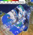
TRMM captured a satellite image of Paul's rainfall on March 30 at 1707 UTC (1:07 p.m. EDT). At that time, Paul's rainfall was mostly light to moderate (between 20 and 40 millimeters or .78 to 1.57 inches per hour) over land and the isolated areas of heavy rain (as much as 2 inches per hour) were confined over the waters of the Gulf of Carpentaria.
TRMM images are pretty complicated to create. They're made at NASA's Goddard Space Flight Center in Greenbelt, Md. At Goddard, rain rates in the center of the swath (the satellite's orbit path over the storm) are created from the TRMM Precipitation Radar (PR) instrument. The TRMM PR is the only space borne radar of its kind. The rain rates in the outer portion of the storm are created from a different instrument on the satellite, called the TRMM Microwave Imager (TMI). The rain rates are then overlaid on infrared (IR) data from the TRMM Visible Infrared Scanner (VIRS). For more information about TRMM, visit: http://www.trmm.gsfc.nasa.gov/.
At 3:30 p.m. CST (02:00 UTC) on March 31, Paul was over land, and about 12 miles (20 kilometers) west of Numbulwar and 65 miles (105 kilometers) west southwest of Alyangula, near 14.3 degrees South and 135.5 degrees East. Paul's center was moving southeast at 6 mph (10 km/hr) per hour. Wind gusts near the low's center have been reported at 52 mph (85 km/hr).
The Joint Typhoon Warning Center issued their final warning on Cyclone Paul on March 30 at 0900 UTC (5 a.m. EDT). Meanwhile, the ABM forecast takes Paul's center back into the Gulf of Carpentaria as a low and toward Port McArthur by April 1.
Source: NASA/Goddard Space Flight Center
Articles on the same topic
- Tropical Storm 23S born in Southern Indian OceanFri, 2 Apr 2010, 19:22:21 UTC
- NASA's TRMM satellite maps Cyclone Paul's extreme rainfall totals in AustraliaFri, 2 Apr 2010, 19:22:20 UTC
- Warnings dropped for ex-cyclone Paul as NASA satellites see it fizzleThu, 1 Apr 2010, 20:50:42 UTC
- TRMM measures Cyclone Paul's rainfall from spaceTue, 30 Mar 2010, 21:50:40 UTC
Other sources
- NASA's TRMM satellite maps Cyclone Paul's extreme rainfall totals in Australiafrom Science BlogFri, 2 Apr 2010, 19:56:19 UTC
- Tropical Storm 23S born in Southern Indian Oceanfrom Science BlogFri, 2 Apr 2010, 19:56:17 UTC
- NASA's TRMM satellite maps Cyclone Paul's extreme rainfall totals in Australiafrom PhysorgFri, 2 Apr 2010, 19:35:21 UTC
- Tropical Storm 23S born in Southern Indian Oceanfrom PhysorgFri, 2 Apr 2010, 19:14:17 UTC
- TRMM satellite sees Paul's low headed back to Gulf of Carpentariafrom Science BlogWed, 31 Mar 2010, 16:56:58 UTC
- TRMM satellite sees Paul's low headed back to Gulf of Carpentariafrom PhysorgWed, 31 Mar 2010, 16:35:18 UTC
- TRMM measures Cyclone Paul's rainfall from spacefrom Science BlogTue, 30 Mar 2010, 22:14:25 UTC
- TRMM measures Cyclone Paul's rainfall from spacefrom PhysorgTue, 30 Mar 2010, 21:49:09 UTC

