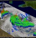
TRMM measures Cyclone Paul's rainfall from space
Having been hit by two tropical cyclones so far this season, Queensland had been the center of tropical cyclone activity, but with the recent arrival of Tropical Cyclone Paul, it is now the Northern Territory's turn to experience heavy rains and gusty winds. Paul originated from a low pressure circulation embedded within the monsoon trough over the Arufura Sea between the northern coast of Australia and New Guinea. As the circulation drifted southward towards northern Australia it intensified slowly and only became a Category 1 cyclone on the evening of March 28, 2010 (local time) when the center was right over the northeast coast of the Northern Territory where it brought wind gusts of up to 110 kph (~70 mph, equivalent to a tropical storm on the US Saffir-Simpson scale).
Since its launch back in 1997, the Tropical Rainfall Measuring Mission satellite (better known as TRMM) has served as a valuable platform for monitoring tropical cyclones using its unique combination of active radar and passive microwave sensors. TRMM captured this first image of Paul at 9:08 UTC on March 28, 2010 (6:38 pm Australian CST) when the center was right over the northeast coast of the Northern Territory. The image shows the horizontal distribution of rain intensity inside the storm. Rain rates in the center of the swath are from the TRMM Precipitation Radar (PR), the only spaceborne precipitation radar of its kind, while those in the outer portion are from the TRMM Microwave Imager (TMI). The rain rates are overlaid on infrared (IR) data from the TRMM Visible Infrared Scanner (VIRS).
Although Paul does not have a visible eye in the IR data, the center of the storm's circulation is clearly evident in the rain pattern over the coast. Paul's center of circulation is bordered by a band of moderate intensity rain to the northwest and surrounded by outer rainbands that spiral inwards to the south and east that have light to moderate rain. Embedded within the rainbands are occasional areas of heavy rain.
TRMM data was used to create a 3-D perspective of the storm from data from TRMM's Precipitation Radar instrument. The most prominent feature is a deep convective tower, which penetrates up to 9 miles (15 km) high. This corresponds with an area of intense rain in the northwestern eyewall evident in the TRMM's image of horizontal rainfall. These tall towers are associated with convective bursts and can be a sign of future strengthening as they indicate areas where heat, known as latent heat, is being released into the storm. This heating is what drives the storm's circulation. Despite Paul's proximity to land, it was able to intensify into a Category 2 cyclone (equivalent to a minimal Category 1 hurricane) by the following morning with wind gusts of up to 140 kph (~85 mph). Paul is hovering over land along the coast and is expected to weaken slowly over the next day or so; however, it could eventually re-emerge over the very warm waters of the Gulf of Carpentaria and re-intensify.
Source: NASA/Goddard Space Flight Center
Articles on the same topic
- Tropical Storm 23S born in Southern Indian OceanFri, 2 Apr 2010, 19:22:21 UTC
- NASA's TRMM satellite maps Cyclone Paul's extreme rainfall totals in AustraliaFri, 2 Apr 2010, 19:22:20 UTC
- Warnings dropped for ex-cyclone Paul as NASA satellites see it fizzleThu, 1 Apr 2010, 20:50:42 UTC
- TRMM satellite sees Paul's low headed back to Gulf of CarpentariaWed, 31 Mar 2010, 15:46:33 UTC
Other sources
- NASA's TRMM satellite maps Cyclone Paul's extreme rainfall totals in Australiafrom Science BlogFri, 2 Apr 2010, 19:56:19 UTC
- Tropical Storm 23S born in Southern Indian Oceanfrom Science BlogFri, 2 Apr 2010, 19:56:17 UTC
- NASA's TRMM satellite maps Cyclone Paul's extreme rainfall totals in Australiafrom PhysorgFri, 2 Apr 2010, 19:35:21 UTC
- Tropical Storm 23S born in Southern Indian Oceanfrom PhysorgFri, 2 Apr 2010, 19:14:17 UTC
- TRMM satellite sees Paul's low headed back to Gulf of Carpentariafrom Science BlogWed, 31 Mar 2010, 16:56:58 UTC
- TRMM satellite sees Paul's low headed back to Gulf of Carpentariafrom PhysorgWed, 31 Mar 2010, 16:35:18 UTC
- TRMM measures Cyclone Paul's rainfall from spacefrom Science BlogTue, 30 Mar 2010, 22:14:25 UTC
- TRMM measures Cyclone Paul's rainfall from spacefrom PhysorgTue, 30 Mar 2010, 21:49:09 UTC
