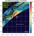
NASA measures winds of Tropical Storm Omais
NASA's RapidScat instrument provided measurements of sustained wind speeds as Tropical Storm Omais was moving past Japan. The RapidScat instrument that flies aboard the International Space Station measures Earth's ocean surface wind speed and direction over open waters. On Aug. 8 RapidScat measured surface winds on the western side of Tropical Storm Omais that were affecting central Japan.
RapidScat measured maximum sustained winds between 56 mph/25 meters per second/90 kph and 67 mph (30 meters per second/108 kph).
RapidScat is an important tool for meteorologists, because it shows forecasters the location of the strongest winds in different quadrants of an area of low pressure or tropical cyclone as they are not always equally distributed. In addition, surface wind speed is always lower than speeds at higher altitude.
The NASA instrument arrived at the International Space Station (ISS) on Sept. 23, 2014, providing a new resource for tracking and studying storms ranging from tropical cyclones to nor'easters.
The Joint Typhoon Warning Center issued their final advisory on Omais on Aug. 8 at 5 p.m. EDT (21:00 UTC). Tropical Storm Omais' maximum sustained winds dropped to 40 knots (46 mph/74 kph). Omais was centered near 37.6 degrees north latitude and 145.2 degrees east longitude, about 259 nautical miles east-northeast of Yokosuka, Japan. Omais was moving to the north-northeast and is expected to continue its life at sea.
On Aug. 9, Omais was transitioning to an extra-tropical cyclone as it continues moving over cooler waters of the northwestern Pacific Ocean.
When a storm becomes extra-tropical, it means that a tropical cyclone has lost its "tropical" characteristics. The National Hurricane Center defines "extra-tropical" as a transition that implies both poleward displacement (meaning it moves toward the north or south pole) of the cyclone and the conversion of the cyclone's primary energy source from the release of latent heat of condensation to baroclinic (the temperature contrast between warm and cold air masses) processes. It is important to note that cyclones can become extra-tropical and still retain winds of hurricane or tropical storm force.
Omais is expected to maintain strength today, Aug. 9, as it moves through the northern Pacific Ocean.
For more information on RapidScat, visit http://www.nasa.gov/rapidscat.
Source: NASA/Goddard Space Flight Center
Articles on the same topic
- NASA sees wind shear relax in Tropical Storm ConsonFri, 12 Aug 2016, 19:04:05 UTC
- NASA measures winds of Tropical Storm ConsonThu, 11 Aug 2016, 19:52:53 UTC
- NASA sees wind shear relax in Tropical Storm ConsonWed, 10 Aug 2016, 15:05:08 UTC
- Satellite sees remnants of Tropical Depression JavierWed, 10 Aug 2016, 14:34:27 UTC
- NASA spots Tropical Storm Javier at southern tip of Baja CaliforniaTue, 9 Aug 2016, 19:04:13 UTC
- NASA spots Tropical Storm Conson facing wind shearTue, 9 Aug 2016, 16:03:20 UTC
- NASA sees Tropical Storm Omais weakening near JapanMon, 8 Aug 2016, 20:03:25 UTC
- NASA gets an infrared look at newly formed Tropical Depression 08WMon, 8 Aug 2016, 19:03:26 UTC
- NASA sees Tropical Storm Javier form in the Eastern PacificMon, 8 Aug 2016, 18:04:30 UTC
- NASA infrared imagery shows Tropical Depression Ivette weakeningMon, 8 Aug 2016, 17:34:25 UTC
- NASA sees Tropical Storm Omais in infrared lightFri, 5 Aug 2016, 18:04:54 UTC
- NASA's Terra satellite sees Tropical Storm Ivette holding steadyFri, 5 Aug 2016, 16:36:27 UTC
- Satellite spots new Tropical Storm Ivette far from Baja CaliforniaFri, 5 Aug 2016, 16:36:16 UTC
- NASA sees Tropical Storm Omais form in Northwestern PacificThu, 4 Aug 2016, 17:53:39 UTC
- NASA sees tropical storm Howard weakeningWed, 3 Aug 2016, 16:10:29 UTC
- NASA catches visible and infrared views of Tropical Storm HowardTue, 2 Aug 2016, 16:35:33 UTC
- NASA spots Tropical Storm Howard developing in Eastern PacificMon, 1 Aug 2016, 17:33:27 UTC
- NASA infrared imagery shows new tropical depression coming togetherMon, 1 Aug 2016, 17:33:04 UTC
- NASA finds Tropical Cyclone Frank fadingMon, 1 Aug 2016, 17:32:54 UTC
Other sources
- NASA measures winds of Tropical Storm Consonfrom PhysorgThu, 11 Aug 2016, 20:11:13 UTC
- NASA sees wind shear relax in Tropical Storm Consonfrom PhysorgWed, 10 Aug 2016, 15:01:30 UTC
- NASA spots Tropical Storm Javier at southern tip of Baja Californiafrom PhysorgTue, 9 Aug 2016, 19:51:26 UTC
- NASA measures winds of Tropical Storm Omaisfrom PhysorgTue, 9 Aug 2016, 19:21:14 UTC
- NASA spots Tropical Storm Conson facing wind shearfrom PhysorgTue, 9 Aug 2016, 16:21:14 UTC
- NASA sees Tropical Storm Omais weakening near Japanfrom PhysorgMon, 8 Aug 2016, 20:01:34 UTC
- NASA gets an infrared look at newly formed Tropical Depression 08Wfrom PhysorgMon, 8 Aug 2016, 19:31:37 UTC
- NASA sees Tropical Storm Javier form in the Eastern Pacificfrom PhysorgMon, 8 Aug 2016, 19:01:29 UTC
- NASA infrared imagery shows Tropical Depression Ivette weakeningfrom PhysorgMon, 8 Aug 2016, 18:02:15 UTC
- NASA sees Tropical Storm Omais in infrared lightfrom PhysorgFri, 5 Aug 2016, 18:31:32 UTC
- Terra satellite sees Tropical Storm Ivette holding steadyfrom PhysorgFri, 5 Aug 2016, 18:01:28 UTC
- NASA sees Tropical Storm Omais form in Northwestern Pacificfrom PhysorgThu, 4 Aug 2016, 18:01:10 UTC
- NASA sees tropical storm Howard weakeningfrom PhysorgWed, 3 Aug 2016, 20:31:42 UTC
- Satellite spots new Tropical Storm Ivette far from Baja Californiafrom PhysorgWed, 3 Aug 2016, 19:31:37 UTC
- NASA catches visible and infrared views of Tropical Storm Howardfrom PhysorgTue, 2 Aug 2016, 17:01:32 UTC
- NASA spots Tropical Storm Howard developing in Eastern Pacificfrom PhysorgMon, 1 Aug 2016, 17:31:29 UTC
- NASA infrared imagery shows new tropical depression coming togetherfrom PhysorgFri, 29 Jul 2016, 19:01:18 UTC
- NASA finds Tropical Cyclone Frank fadingfrom PhysorgThu, 28 Jul 2016, 17:01:30 UTC
