NASA spots Tropical Storm Howard developing in Eastern Pacific
Infrared data from NASA's Aqua satellite showed strong thunderstorms within the ninth tropical depression of the Eastern Pacific Ocean, as the storm was strengthening. Early on Aug. 1 Tropical Depression 9E intensified into a tropical storm and was renamed Howard. Tropical Storm Howard, the ninth tropical cyclone to develop in 30 days in the Eastern Pacific is also the eighth named storm of the 2016 season. Tropical Depression 1E in June was the only tropical cyclone that developed this season and did not reach tropical storm status.
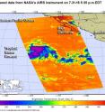
On July 31, at 5:05 p.m. EDT (9:05 p.m. UTC) the Atmospheric Infrared Sounder or AIRS instrument aboard NASA's Aqua satellite captured infrared data on Tropical Depression 9E. The AIRS data showed that the coldest cloud top temperatures of at least minus 63 F (minus 53 C) and strongest thunderstorms circled the low-level center with the exception of the northern quadrant of the storm. Strong storms also fed into the low level center from a band of thunderstorms southwest of the center.
Over the course of 12 hours, the cloud pattern of the cyclone improved. At 5 a.m. EDT (9: a.m. UTC) on Aug. 1, the depression became a tropical storm. At that time, Tropical Storm Howard's maximum sustained winds were near 40 mph (65 kph) with higher gusts. The center of Tropical Storm Howard was located near 16.1 degrees north latitude and 122.9 degrees west longitude, about 965 miles (1,555 km) west-southwest of the southern tip of Baja California, Mexico. Since Howard is far enough away from land areas there are no coastal watches or warnings in effect.
The National Hurricane Center NHC said that Howard was moving toward the west-northwest near 10 mph (17 kph) and this general motion is expected to continue for the next couple of days. The estimated minimum central pressure was 1,005 millibars.
The NHC forecast indicated that some additional strengthening is forecast today and Tuesday morning. Then, gradual weakening is expected to begin by Tuesday night and Wednesday when Howard moves over cooler water.
Source: NASA/Goddard Space Flight Center
Articles on the same topic
- NASA sees wind shear relax in Tropical Storm ConsonFri, 12 Aug 2016, 19:04:05 UTC
- NASA measures winds of Tropical Storm ConsonThu, 11 Aug 2016, 19:52:53 UTC
- NASA sees wind shear relax in Tropical Storm ConsonWed, 10 Aug 2016, 15:05:08 UTC
- Satellite sees remnants of Tropical Depression JavierWed, 10 Aug 2016, 14:34:27 UTC
- NASA spots Tropical Storm Javier at southern tip of Baja CaliforniaTue, 9 Aug 2016, 19:04:13 UTC
- NASA measures winds of Tropical Storm OmaisTue, 9 Aug 2016, 19:04:00 UTC
- NASA spots Tropical Storm Conson facing wind shearTue, 9 Aug 2016, 16:03:20 UTC
- NASA sees Tropical Storm Omais weakening near JapanMon, 8 Aug 2016, 20:03:25 UTC
- NASA gets an infrared look at newly formed Tropical Depression 08WMon, 8 Aug 2016, 19:03:26 UTC
- NASA sees Tropical Storm Javier form in the Eastern PacificMon, 8 Aug 2016, 18:04:30 UTC
- NASA infrared imagery shows Tropical Depression Ivette weakeningMon, 8 Aug 2016, 17:34:25 UTC
- NASA sees Tropical Storm Omais in infrared lightFri, 5 Aug 2016, 18:04:54 UTC
- NASA's Terra satellite sees Tropical Storm Ivette holding steadyFri, 5 Aug 2016, 16:36:27 UTC
- Satellite spots new Tropical Storm Ivette far from Baja CaliforniaFri, 5 Aug 2016, 16:36:16 UTC
- NASA sees Tropical Storm Omais form in Northwestern PacificThu, 4 Aug 2016, 17:53:39 UTC
- NASA sees tropical storm Howard weakeningWed, 3 Aug 2016, 16:10:29 UTC
- NASA catches visible and infrared views of Tropical Storm HowardTue, 2 Aug 2016, 16:35:33 UTC
- NASA infrared imagery shows new tropical depression coming togetherMon, 1 Aug 2016, 17:33:04 UTC
- NASA finds Tropical Cyclone Frank fadingMon, 1 Aug 2016, 17:32:54 UTC
