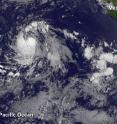
Satellite spots new Tropical Storm Ivette far from Baja California
Tropical Depression 10E formed on Aug. 2 around 5 p.m. EDT and strengthened into Tropical Storm Ivette 12 hours later at 5 a.m. EDT on Aug. 3. NOAA's GOES-West satellite spotted Ivette almost 900 miles southwest of the southern tip of Baja California, Mexico on Aug. 3. The visible image from NOAA's GOES-West satellite from Aug. 3 at 11 a.m. EDT shows a concentrated ring of thunderstorms around the center of Tropical Storm Ivette and a band of thunderstorms west of the center.
National Hurricane Center (NHC) forecaster Berg said, "However, recent microwave data still shows the low-level center displaced to the northeast of the deepest convection due to some [vertical wind] shear."
At 11 a.m. EDT (1500 UTC) the center of Tropical Storm Ivette was located near 14.6 degrees north latitude and 120.4 degrees west longitude. That's about 895 miles (1,440 km) southwest of the southern tip of Baja California. Ivette is moving toward the west-northwest near 17 mph (28 kph). NHC forecasts a westward motion with a gradual decrease in forward speed during the next couple of days.
Maximum sustained winds have increased to near 45 mph (75 kph) with higher gusts. Additional strengthening is forecast during the next 48 hours, and Ivette is expected to become a hurricane by Thursday night.
For updated forecasts, visit NHC: http://www.nhc.noaa.gov.
Source: NASA/Goddard Space Flight Center
Articles on the same topic
- NASA sees wind shear relax in Tropical Storm ConsonFri, 12 Aug 2016, 19:04:05 UTC
- NASA measures winds of Tropical Storm ConsonThu, 11 Aug 2016, 19:52:53 UTC
- NASA sees wind shear relax in Tropical Storm ConsonWed, 10 Aug 2016, 15:05:08 UTC
- Satellite sees remnants of Tropical Depression JavierWed, 10 Aug 2016, 14:34:27 UTC
- NASA spots Tropical Storm Javier at southern tip of Baja CaliforniaTue, 9 Aug 2016, 19:04:13 UTC
- NASA measures winds of Tropical Storm OmaisTue, 9 Aug 2016, 19:04:00 UTC
- NASA spots Tropical Storm Conson facing wind shearTue, 9 Aug 2016, 16:03:20 UTC
- NASA sees Tropical Storm Omais weakening near JapanMon, 8 Aug 2016, 20:03:25 UTC
- NASA gets an infrared look at newly formed Tropical Depression 08WMon, 8 Aug 2016, 19:03:26 UTC
- NASA sees Tropical Storm Javier form in the Eastern PacificMon, 8 Aug 2016, 18:04:30 UTC
- NASA infrared imagery shows Tropical Depression Ivette weakeningMon, 8 Aug 2016, 17:34:25 UTC
- NASA sees Tropical Storm Omais in infrared lightFri, 5 Aug 2016, 18:04:54 UTC
- NASA's Terra satellite sees Tropical Storm Ivette holding steadyFri, 5 Aug 2016, 16:36:27 UTC
- NASA sees Tropical Storm Omais form in Northwestern PacificThu, 4 Aug 2016, 17:53:39 UTC
- NASA sees tropical storm Howard weakeningWed, 3 Aug 2016, 16:10:29 UTC
- NASA catches visible and infrared views of Tropical Storm HowardTue, 2 Aug 2016, 16:35:33 UTC
- NASA spots Tropical Storm Howard developing in Eastern PacificMon, 1 Aug 2016, 17:33:27 UTC
- NASA infrared imagery shows new tropical depression coming togetherMon, 1 Aug 2016, 17:33:04 UTC
- NASA finds Tropical Cyclone Frank fadingMon, 1 Aug 2016, 17:32:54 UTC
