NASA finds Tropical Cyclone Frank fading
Related images
(click to enlarge)
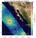
Tropical Storm Frank weakened to a tropical storm on July 28, 2016 and satellite imagery shows that winds and thunderstorms have continued to weaken. On July 27, NASA's RapidScat instrument observed Frank's strongest sustained winds were near 30 meters per second (67 mph/108 kph) north of the center. Tropical-storm-force winds extended outward up to 60 miles (95 km) from the center. Frank weakened from a hurricane to a tropical storm by 5 p.m. EDT on July 27.
The RapidScat instrument flies aboard the International Space Station and measures winds over an ocean surface. Images are created at NASA's Jet Propulsion Laboratory in Pasadena, California.
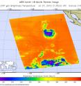
Later on July 27, at 21:35 UTC (5:35 p.m. EDT) the Atmospheric Infrared Sounder or AIRS instrument aboard NASA's Aqua satellite captured infrared data of Frank. The AIRS data showed that the coldest cloud top temperatures of at least minus 63 degrees Fahrenheit (minus 53 degrees Celsius) and strongest thunderstorms were only along the southern quadrant of the storm.
At 5 a.m. EDT (0900 UTC), the center of Tropical Storm Frank was located near 23.6 degrees latitude and 123.7 degrees west longitude. That's about 875 miles (1,410 km west of the southern tip of Baja California. Maximum sustained winds have decreased to near 40 mph (65 kph) with higher gusts.
Frank was moving toward the west-northwest near 9 mph (15 kph), and the National Hurricane Center expects a gradual turn toward the west and west-southwest over the next 48 hours as the storm weakens.
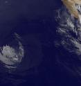
NOAA GOES-West infrared image of Tropical Storm Frank was taken on July 28, 2016 at 1315 UTC (9:15 a.m. EDT). The GOES-West image showed very weak storms and mostly along the southern quadrant, as the infrared imagery from AIRS had shown 16 hours before. The GOES image was generated at the NASA/NOAA GOES Project at NASA's Goddard Space Flight Center, Greenbelt, Maryland.
Forecaster Pasch at NOAA's National Hurricane Center (NHC) said that "All of the deep convection associated with Frank has dissipated, and since the cyclone is moving over waters cooler than 23 degrees Celsius, regeneration of thunderstorms within the circulation is not anticipated. Therefore, the cyclone is likely to degenerate into a post-tropical remnant low pressure area later today.
NHC said that the storm will continue to weaken as the circulation spins down over the next couple of days. Frank is expected to dissipate by Sunday, July 31.
Source: NASA/Goddard Space Flight Center
Articles on the same topic
- NASA sees wind shear relax in Tropical Storm ConsonFri, 12 Aug 2016, 19:04:05 UTC
- NASA measures winds of Tropical Storm ConsonThu, 11 Aug 2016, 19:52:53 UTC
- NASA sees wind shear relax in Tropical Storm ConsonWed, 10 Aug 2016, 15:05:08 UTC
- Satellite sees remnants of Tropical Depression JavierWed, 10 Aug 2016, 14:34:27 UTC
- NASA spots Tropical Storm Javier at southern tip of Baja CaliforniaTue, 9 Aug 2016, 19:04:13 UTC
- NASA measures winds of Tropical Storm OmaisTue, 9 Aug 2016, 19:04:00 UTC
- NASA spots Tropical Storm Conson facing wind shearTue, 9 Aug 2016, 16:03:20 UTC
- NASA sees Tropical Storm Omais weakening near JapanMon, 8 Aug 2016, 20:03:25 UTC
- NASA gets an infrared look at newly formed Tropical Depression 08WMon, 8 Aug 2016, 19:03:26 UTC
- NASA sees Tropical Storm Javier form in the Eastern PacificMon, 8 Aug 2016, 18:04:30 UTC
- NASA infrared imagery shows Tropical Depression Ivette weakeningMon, 8 Aug 2016, 17:34:25 UTC
- NASA sees Tropical Storm Omais in infrared lightFri, 5 Aug 2016, 18:04:54 UTC
- NASA's Terra satellite sees Tropical Storm Ivette holding steadyFri, 5 Aug 2016, 16:36:27 UTC
- Satellite spots new Tropical Storm Ivette far from Baja CaliforniaFri, 5 Aug 2016, 16:36:16 UTC
- NASA sees Tropical Storm Omais form in Northwestern PacificThu, 4 Aug 2016, 17:53:39 UTC
- NASA sees tropical storm Howard weakeningWed, 3 Aug 2016, 16:10:29 UTC
- NASA catches visible and infrared views of Tropical Storm HowardTue, 2 Aug 2016, 16:35:33 UTC
- NASA spots Tropical Storm Howard developing in Eastern PacificMon, 1 Aug 2016, 17:33:27 UTC
- NASA infrared imagery shows new tropical depression coming togetherMon, 1 Aug 2016, 17:33:04 UTC
Other sources
- NASA measures winds of Tropical Storm Consonfrom PhysorgThu, 11 Aug 2016, 20:11:13 UTC
- NASA sees wind shear relax in Tropical Storm Consonfrom PhysorgWed, 10 Aug 2016, 15:01:30 UTC
- NASA spots Tropical Storm Javier at southern tip of Baja Californiafrom PhysorgTue, 9 Aug 2016, 19:51:26 UTC
- NASA measures winds of Tropical Storm Omaisfrom PhysorgTue, 9 Aug 2016, 19:21:14 UTC
- NASA spots Tropical Storm Conson facing wind shearfrom PhysorgTue, 9 Aug 2016, 16:21:14 UTC
- NASA sees Tropical Storm Omais weakening near Japanfrom PhysorgMon, 8 Aug 2016, 20:01:34 UTC
- NASA gets an infrared look at newly formed Tropical Depression 08Wfrom PhysorgMon, 8 Aug 2016, 19:31:37 UTC
- NASA sees Tropical Storm Javier form in the Eastern Pacificfrom PhysorgMon, 8 Aug 2016, 19:01:29 UTC
- NASA infrared imagery shows Tropical Depression Ivette weakeningfrom PhysorgMon, 8 Aug 2016, 18:02:15 UTC
- NASA sees Tropical Storm Omais in infrared lightfrom PhysorgFri, 5 Aug 2016, 18:31:32 UTC
- Terra satellite sees Tropical Storm Ivette holding steadyfrom PhysorgFri, 5 Aug 2016, 18:01:28 UTC
- NASA sees Tropical Storm Omais form in Northwestern Pacificfrom PhysorgThu, 4 Aug 2016, 18:01:10 UTC
- NASA sees tropical storm Howard weakeningfrom PhysorgWed, 3 Aug 2016, 20:31:42 UTC
- Satellite spots new Tropical Storm Ivette far from Baja Californiafrom PhysorgWed, 3 Aug 2016, 19:31:37 UTC
- NASA catches visible and infrared views of Tropical Storm Howardfrom PhysorgTue, 2 Aug 2016, 17:01:32 UTC
- NASA spots Tropical Storm Howard developing in Eastern Pacificfrom PhysorgMon, 1 Aug 2016, 17:31:29 UTC
- NASA infrared imagery shows new tropical depression coming togetherfrom PhysorgFri, 29 Jul 2016, 19:01:18 UTC
- NASA finds Tropical Cyclone Frank fadingfrom PhysorgThu, 28 Jul 2016, 17:01:30 UTC


