NASA sees Tropical Cyclone Fantala slowing
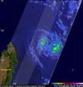
On April 21, Fantala's maximum sustained wind speeds started to decrease since making a "U-turn" and moving southeastward to a position northeast of Madagascar and the storm maintained strength on April 22. NASA's RapidScat instrument measured winds around the system while NASA-JAXA's Global Precipitation Measurement or GPM core satellite analyzed rainfall rates with the hurricane. The GPM core observatory satellite flew above Tropical Cyclone Fantala on April 21, 2016 at 0021 UTC (April 20 at 8:21 p.m. EDT) when the tropical cyclone's maximum sustained winds were estimated at 105 knots (121 mph). GPM's Microwave Imager (GMI) and Dual-Frequency Precipitation Radar (DPR) data were used to estimate the rainfall within Fantala. DPR indicated that Fantala was dropping rain at a rate of over 120 mm (4.7 inches) per hour in an area of intense rainfall west of the eye. GPM's radar (DPR Ku Band) found that the highest storm tops in that area were reaching altitudes of just over 12 km (7.4 mile). GPM's radar data (DPR Ku band) were used to show a 3-D slice through this stormy area where radar reflectivity values of over 52.6 dBZ were being returned to the satellite.
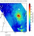
On Apr. 21 at 6 p.m. UTC (2 p.m. EDT) the RapidScat instrument that flies aboard the International Space Station (ISS) measured Fantala's surface wind speed and direction over the Southern Indian Ocean. Wind speeds exceeded 30 meters per second (67 mph/108 kph) around the entire center of the storm with the exception of the southwestern quadrant where winds were slightly weaker. RapidScat showed that winds of 34 knots (39 mph/62 kph) or higher occur within 75 nautical miles (86.3 miles/138.9 km) of the center
RapidScat is an important tool for meteorologists, because it shows forecasters the location of the strongest winds in different quadrants of an area of low pressure or tropical cyclone as they are not always equally distributed. In addition, surface wind speed is always lower than speeds at higher altitude.
On Friday, April 22 at 0900 UTC (5 a.m. EDT) Tropical Cyclone Fantala's maximum sustained winds remained near 90 knots (103.6 mph/ 166.7 kph) where they were 24 hours before. The storm is maintaining strength as it slowly moves to the southeast at 1 knot (1.1 mph/1.8 kph). Forecasters at the Joint Typhoon Warning Center expect the storm to turn back to the west-northwest later in the day.
Fantala was centered near 13.2 degrees south latitude and 57.1 degrees east longitude, about 414 nautical miles (476 .4 miles/766.7 km) north of Port Louis, Mauritius.
The Joint Typhoon Warning Center (JTWC) predicts that Tropical Cyclone Fantala will head toward the northwest while briefly intensifying. The tropical cyclone is expected to then encounter adverse conditions that will prompt a weakening trend north of Madagascar as it continues to move west toward the African mainland.
Source: NASA/Goddard Space Flight Center
Articles on the same topic
- NASA sees wind shear end Tropical Cyclone AmosMon, 25 Apr 2016, 15:03:46 UTC
- NASA sees Tropical Cyclone Amos threatening American SamoaFri, 22 Apr 2016, 20:02:56 UTC
- NASA sees Tropical Cyclone Amos intensifyingThu, 21 Apr 2016, 16:38:16 UTC
- NASA sees changes in Tropical Cyclone FantalaThu, 21 Apr 2016, 14:38:14 UTC
- NASA sees birth of Tropical Cyclone 20P, threatens American SamoaWed, 20 Apr 2016, 16:35:21 UTC
- NASA sees Fantala's eye wide open north of MadagascarWed, 20 Apr 2016, 14:08:01 UTC
- NASA's 3-satellite view of powerful Tropical Cyclone FantalaTue, 19 Apr 2016, 16:03:48 UTC
- NASA examines Category 5 Tropical Cyclone Fantala near MadagascarTue, 19 Apr 2016, 16:03:39 UTC
- NASA eyes major Tropical Cyclone Fantala as it triggers warnings for MauritiusTue, 19 Apr 2016, 16:03:28 UTC
Other sources
- NASA sees wind shear end Tropical Cyclone Amosfrom PhysorgMon, 25 Apr 2016, 15:20:58 UTC
- NASA sees Tropical Cyclone Amos threatening American Samoafrom PhysorgFri, 22 Apr 2016, 22:00:57 UTC
- NASA sees Tropical Cyclone Fantala slowingfrom PhysorgFri, 22 Apr 2016, 16:30:48 UTC
- NASA sees Tropical Cyclone Amos intensifyingfrom PhysorgThu, 21 Apr 2016, 17:00:59 UTC
- NASA sees changes in Tropical Cyclone Fantalafrom PhysorgThu, 21 Apr 2016, 15:00:54 UTC
- NASA sees birth of Tropical Cyclone 20P, threatens American Samoafrom PhysorgWed, 20 Apr 2016, 17:31:14 UTC
- NASA sees Fantala's eye wide open north of Madagascarfrom PhysorgWed, 20 Apr 2016, 15:31:52 UTC
- NASA's 3-satellite view of powerful Tropical Cyclone Fantalafrom PhysorgTue, 19 Apr 2016, 16:00:55 UTC
- NASA examines Category 5 Tropical Cyclone Fantala near Madagascarfrom PhysorgMon, 18 Apr 2016, 15:41:38 UTC
- NASA eyes major Tropical Cyclone Fantala as it triggers warnings for Mauritiusfrom PhysorgSat, 16 Apr 2016, 8:10:45 UTC

